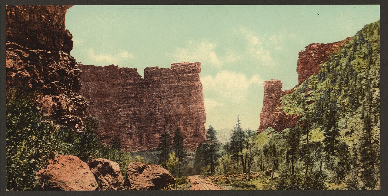
The twin sandstone towers of the Castle Gate formation framing the railroad in Price Canyon, Utah, around 1900

Castle Gate, Utah

Utah Coal Mining The coal gate of Price Canyon · 1880s–1974 15 min read
Founded
Coal camp ~1886–88 on the Denver & Rio Grande; incorporated 1914
Peak Population
1,120 (1920 census) — the documented high
County / Region
Carbon County · Price Canyon, Wasatch Plateau coal belt
What Happened
Coal economy declined; the town was bought and cleared for mine machinery in 1974
Still Standing
No town buildings. Castle Gate Cemetery, roadside disaster memorial, and one altered sandstone “gate”
Status
Townsite reclaimed; active railroad & private industrial land. See it from US-6 pullouts
Free — no fee Viewed from US-6 pullouts Cemetery open to the public Active rail & private land No townsite buildings remain The twin sandstone towers of the Castle Gate formation framing the railroad and Price River in Price Canyon, Utah, around 1900.
The original Castle Gate — two sandstone fins framing the railroad, river, and road through Price Canyon. Detroit Publishing Co. (W. H. Jackson), c.1900; Library of Congress, public domain.

Castle Gate was never a conventional frontier town that happened to find coal. It was the opposite — a railroad-and-coal company settlement that existed for one reason: to dig high-grade bituminous coal out of the walls of Price Canyon and load it onto the Denver & Rio Grande. It grew up in the 1880s beside one of Utah’s most photographed natural landmarks, the twin sandstone “gate” that gave the place its name, and it became one of the most ethnically mixed industrial communities in the state — a canyon where Italian, Greek, Japanese, Austrian, South Slavic, and British miners worked the same seams.

In its lifetime Castle Gate collected more drama than towns ten times its size: Butch Cassidy’s most famous Utah holdup, two of the bitterest strikes in the Western coalfields, a reservoir flood, and — on one Saturday morning in 1924 — one of the deadliest mine explosions in American history. And then, unusually for a ghost town, it didn’t simply fade. In 1974 a new mine owner bought the whole town, hauled off the houses, bulldozed the rest, and cleared the ground for modern coal machinery. This is the documented history of that town, the legends worth separating from the record, and how to see what little remains.

“…effectively an ‘Italian mine.’” — How a Pleasant Valley Coal Company officer described Castle Gate’s workforce during the 1903–04 strike; his own tally ran 356 Italians to 108 English-speaking miners and 10 Austrians.

Coal, the Rio Grande, and the making of the gate

Coal came to the Wasatch Plateau before Castle Gate did. The Pleasant Valley Coal Company, organized by Sanpete-area entrepreneurs in the 1870s, opened the region’s first underground workings at Winter Quarters near Scofield. In 1882 the Denver & Rio Grande acquired the company and its railroad, giving the railroad both a captive fuel supply and control of a fast-developing coal district; the Rio Grande’s main line to Salt Lake City was completed in 1883, turning hard-to-market coal into a major commercial resource.

Castle Gate itself is best understood as a sequence rather than a single founding day. Railroad photographs show trains at the gate in the mid-1880s; the first Castle Gate mine was driven into the western canyon wall about 1886; and Utah historical scholarship places the recognizable coal camp at about 1888, when the Pleasant Valley Coal Company began commercial mining. The earliest workforce lived in repurposed D&RGW boxcars parked on sidings beside the river until permanent houses went up. In 1889 the company built Utah’s first battery of beehive coke ovens along the mainline; in 1899 operations were consolidated under the Utah Fuel Company, a wholly owned Rio Grande subsidiary. The town took its name from the paired sandstone walls at the narrow pinch of the canyon — a landmark the railroad made famous on postcards and tourist routes long before most people had heard of its mines.

On the population numbers. The firmest figure is also a modest one: 1,120 residents in the incorporated town in the 1920 federal census — the highest decennial count that can be verified — falling to 923 (1930), 851 (1940), and 701 (1950). Local narratives sometimes give much larger “peak” figures by counting a broader camp, transient miners, or the whole precinct (one source cites 700–1,500 depending on the season). Those are worth knowing, but they shouldn’t be substituted for the Census Bureau’s incorporated-place count.

An international company town

Castle Gate was laid out along the narrow canyon floor and up the side-draws, a compact grid squeezed between the cliffs and the rails. It ran on classic company-town paternalism: although the town incorporated as a municipality in 1914, the Utah Fuel Company owned the lots, the wood-frame houses, the commercial buildings, and the water system. Miners were paid through an account tied to the company’s Wasatch Store, where scrip and credit governed daily life, and company guards patrolled the canyon road, turning away independent merchants to protect the store’s monopoly.

Within that tight corporate frame the residents still built a real community rather than a temporary camp. There was a company hospital with staff physicians, an amusement hall that hosted movies, theater, and lodge meetings, a hillside school (rebuilt in 1916) teaching grades one through nine, two churches, a hotel, boarding houses, a confectionery, a saloon, and a baseball field with a competitive industrial team. The demographic mix was extraordinary: English, Scottish, Welsh, and Scandinavian miners early on, then after the late 1890s a flood of Italians — so many that observers called Castle Gate the “Italian mine” — followed by Greeks (many from Crete), Austrians, Slovenians, Croats, Finns, and Japanese. By 1920 the canyon drew on more than thirty nationalities.
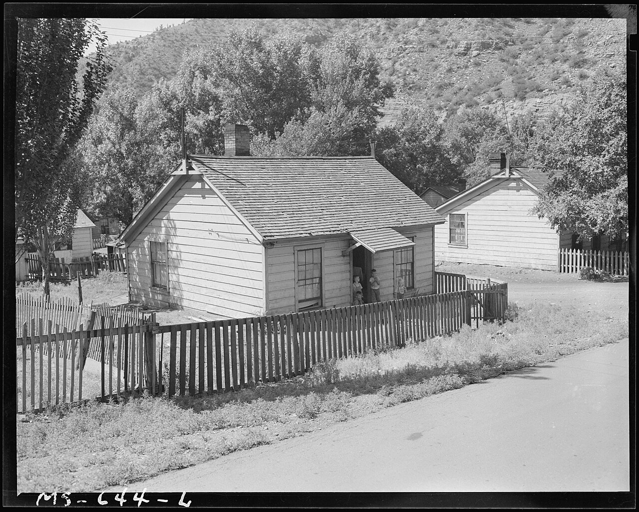
A wood-frame company house at the Utah Fuel Company's Castle Gate mine, home of miner John M. McPhie, photographed in 1946.
Company housing at Castle Gate — miner John M. McPhie’s home, part of the Utah Fuel Company project. Russell Lee, 1946; U.S. National Archives, public domain.

Butch Cassidy and the Castle Gate payroll robbery

Castle Gate entered Western folklore at midday on April 21, 1897, when armed men robbed the Pleasant Valley Coal Company’s payroll in broad daylight. The Utah State Archives identifies the robbers as Butch Cassidy (Robert LeRoy Parker) and Elzy Lay, and preserves the Carbon County grand-jury indictment. The outlaws confronted company cashier E. L. Carpenter and a clerk as they carried the payroll the short distance from the rail depot toward the company store, forced them to hand over the money bags, fired shots to sow confusion, and rode south at a dead run. A confederate cut the telegraph wire to delay any posse, and through pre-arranged horse relays the pair vanished toward the canyon country of Robbers Roost.

How big was the haul — $1,000 or $9,000 in gold? This is where the archive and the legend part ways. The Utah State Archives says the surviving court records put the stolen bag of silver coins at about $1,000, and notes explicitly that the story “accumulated embellishments over the decades.” Popular retellings — and the richer secondary accounts — describe three canvas bags and a satchel holding $7,000 to $8,800 (or more) in gold, with roughly $1,000 later recovered. Both versions circulate; the modest, archivally grounded figure is the safer one, and the tales of Cassidy paying off widows’ mortgages or burying gold in the San Rafael Swell are folklore, not record. (The wooden store staircase where Cassidy drew his gun was salvaged and is preserved at the Western Mining & Railroad Museum in Helper.)

The coal wars: 1903–04 and 1922

Because Utah Fuel controlled wages, housing, safety, and the dockage rates that docked a miner’s pay for rock in the coal car, Castle Gate was a natural flashpoint in the long fight between the operators and the United Mine Workers of America. The first great confrontation came in the winter of 1903–04, when Castle Gate miners joined a regional strike for union recognition, fair weighing, and an end to forced patronage of the Wasatch Store. The legendary organizer Mary Harris “Mother” Jones came to Price Canyon to rally the immigrant miners and their wives; company and county officials retaliated by placing her under a questionable smallpox quarantine to break up her meetings.

As the strike dragged into the spring of 1904, the Carbon County sheriff and an armed company posse raided Castle Gate and arrested roughly 120 striking Italian miners, marching them into boxcars and holding them in an open-air bullpen in Price. Governor Heber M. Wells ordered the Utah National Guard into the canyon — stationing troops with Gatling guns on the heights — and the combination of mass arrests, evictions, and blacklisting broke the strike and opened the door to Greek strikebreakers who would become one of the camp’s dominant communities. Carbon County erupted again during the national coal strike of 1922: Governor Charles R. Mabey declared martial law, the Guard returned, and strikers were evicted into tent colonies until the stoppage collapsed.

March 8, 1924: the Castle Gate mine disaster

At about 8:30 on the morning of Saturday, March 8, 1924, a series of violent explosions tore through Castle Gate Mine No. 2 in Willow Creek Canyon, where roughly 171 men were working. The mechanism was the classic killer of coal mines: a pocket of methane (firedamp) ignited, and the blast threw highly combustible, insufficiently wetted coal dust into the air, which fueled a second, catastrophic explosion that swept for miles through the workings. The force blew heavy timbers out of the portal and more than a thousand feet across the canyon. No one underground survived.
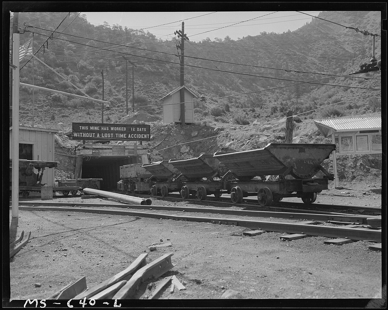
The portal of the Utah Fuel Company's Castle Gate coal mine, photographed in 1946.
A portal of the Utah Fuel Company’s Castle Gate mine, photographed in 1946 — the kind of entry from which the 1924 blast hurled timbers across the canyon. Russell Lee, 1946; U.S. National Archives, public domain.
Why you’ll see both 171 and 172 dead. The clearest way to state the toll is 171 miners killed underground, plus one rescue worker who later died of mine gases — 29-year-old George Wilson, captain of the Standardville rescue team, whose breathing apparatus failed during the search. Modern Utah Historical Society accounts use 171 for the men inside the mine; state and union accounts total 172 when Wilson is counted. The victims ranged from about 15 to 73 years old and included 62 Greeks alongside Italians, Austrians, Slavs, Scots, and native-born Americans. The blast left roughly 110–115 widows and several hundred fatherless children.

The response became a landmark in Utah’s social history. Governor Mabey issued a statewide appeal that raised $132,445 for long-term relief, and the committee hired Annie D. Palmer — one of Utah’s first professional social caseworkers — who spent years assessing families, setting living allowances, and monitoring the widows and orphans until the fund closed in December 1935. The disaster also fed the national push for mine safety: Utah and the U.S. Bureau of Mines moved toward mandatory rock-dusting, bans on open-flame inspection, and electric cap lamps underground. (It would be an overstatement to say Castle Gate alone created the modern federal safety regime, but it was one of the disasters that made the case.) The single most affecting first-person source is Saline Hardee Fraser’s memoir “One Long Day that Went on Forever,” written by a woman who was thirteen when she lost both her father and grandfather in the mine.

The 1917 flood — and the wallpaper story. Seven years before the explosion, Castle Gate survived a different disaster: in June 1917 the failure of the Mammoth reservoir/dam system sent a destructive flood down Price Canyon, damaging rail infrastructure and buildings. That flood is firmly historical. The colorful local tale — that resident Ben Ludwig refused to evacuate until he’d finished hanging his wallpaper — survives as a repeated regional anecdote and should be enjoyed as storytelling, not treated as documented fact on the level of the mine and railroad records.

The gate, the town, and a deliberate erasure

Castle Gate’s decline was slow and structural. As railroads switched from steam to diesel and households turned to oil, gas, and electricity, Utah’s coal camps contracted and mechanization cut the number of miners needed per ton — a slide the census captures cleanly, from 1,120 in 1920 to 701 by 1950. Mining continued, and in the 1950s a new presence rose beside the river: Utah Power & Light’s Carbon (Castle Gate) Steam Generating Plant, begun in 1953, with its first unit online in 1954 and a second in 1957 — Utah’s first major mine-mouth coal station. It ran for six decades until PacifiCorp retired it in 2015; the plant was demolished and the ground reclaimed by 2017.

The famous rock came down first. The original gate was two parallel sandstone fins; in 1931 the state drove a 400-foot highway tunnel through the base of the western fin. By the 1960s the tunnel was a dangerous bottleneck, and as part of a major highway-modernization project contractors drilled and blasted the western monolith away, opening a wide rock cut roughly 280 feet deep.

Was the gate dynamited in 1960 — or 1965–66? You’ll see “1960” repeated in many popular histories, and it’s worth a caution flag. That one side of the gate was blasted during highway widening is not in doubt. But the detailed highway record points to the western fin and its tunnel being drilled and dynamited in 1965–66, with the widened Price Canyon road opening on July 28, 1966 — when the state highway director publicly acknowledged the loss of the landmark and noted that travel time through the canyon had dropped from about 25 minutes to 9. UDOT also dates completion of the major new alignment to 1966. Treat “dynamited in 1960” as a widely repeated secondary date, not one proven from a construction file.

The town went next, and on purpose. In 1971 the Los Angeles–based McCulloch Oil Corporation acquired the local coal interests and, through its Braztah subsidiary, planned an automated coal-preparation complex with washing circuits, storage silos, and a unit-train loading loop. The sheer canyon walls left nowhere to build but the flat river bottom — the ground the town stood on. So in 1974 Castle Gate was disincorporated and dismantled. This was not an ordinary abandonment: houses were sold and physically moved, chiefly to a new Castle Gate subdivision near Helper, and the masonry buildings that couldn’t be moved — the Wasatch Store, the hospital, churches, the school — were bulldozed. Residents held a final gathering in the old amusement hall during the week of demolition.

How many houses were moved? Accounts disagree, and the disagreement is worth keeping rather than hiding. One chronology records 61 houses moved; another describes “60 of 72” owners electing relocation; a local history says simply 60 wood-frame houses were hauled five miles south to Spring Canyon. The safest formulation is that several dozen Castle Gate houses were relocated. The event itself — the organized removal of nearly the entire remaining town — is well documented; the exact count depends on whether a source is counting homeowners, houses offered relocation, or houses actually moved.

There was even a second erasure. The coal-handling infrastructure that replaced the town survived into the early 2000s before it, too, was dismantled and the valley floor reclaimed. Mining continued nearby — Cyprus Plateau opened the underground Willow Creek Mine in 1998 — until fatal fires and methane explosions in the summer of 2000 killed two miners and led the owner to close it that December. Today the canyon floor that once held a town, mines, a railroad yard, a coal plant, and a generating station is mostly reclaimed ground and active Union Pacific track.

Timeline

1882–83
The Denver & Rio Grande acquires the Pleasant Valley Coal Company; its line reaches Salt Lake City.
~1886–88
The first Castle Gate mine is driven; the coal camp takes shape. Coke ovens follow in 1889.
1897
Butch Cassidy and Elzy Lay rob the Pleasant Valley Coal Company payroll at Castle Gate (April 21).
1899
Operations consolidate under the Utah Fuel Company, a Rio Grande subsidiary.
1903–04
A bitter coal strike; Mother Jones organizes; ~120 Italian miners are arrested and the Guard occupies the canyon.
1914
Castle Gate incorporates as a municipality (though Utah Fuel still owns the town).
1917
The Mammoth reservoir fails; a flood sweeps down Price Canyon.
1920
Census peak of 1,120 residents drawn from more than thirty nationalities.
1922
A second major strike; Gov. Mabey declares martial law in Carbon County.
1924
The No. 2 mine explodes on March 8, killing 171 miners and rescuer George Wilson; $132,445 is raised for relief.
1954–57
Utah Power & Light’s mine-mouth Carbon power plant comes online beside the river.
1965–66
The western “gate” fin and its 1931 tunnel are blasted away for the widened US-6; the road opens July 28, 1966.
1974
McCulloch Oil / Braztah clears the town: houses moved to Helper, masonry bulldozed, Castle Gate disincorporated.
1987
The Castle Gate Mine Disaster Memorial is dedicated (Oct. 3), naming the 172 victims.
1998–2000
The nearby Willow Creek Mine opens, then closes after fatal explosions kill two miners in 2000.
2015–17
The Carbon power plant is retired (2015), demolished, and the site reclaimed.

Seeing Castle Gate now

There is no preserved Castle Gate ghost-town park — no streets of empty buildings to walk. The town is gone from the canyon floor, and what remains of its mine and railroad ground is private, industrial, or reclaimed. What you can see honestly is the setting: the surviving cliffs and rock cut from a roadside pullout, a disaster memorial, and the cemetery on the hill. The richest surviving built environment is actually in Helper, four miles south, whose historic district and mining museum preserve far more of the Castle Gate story than the site itself.
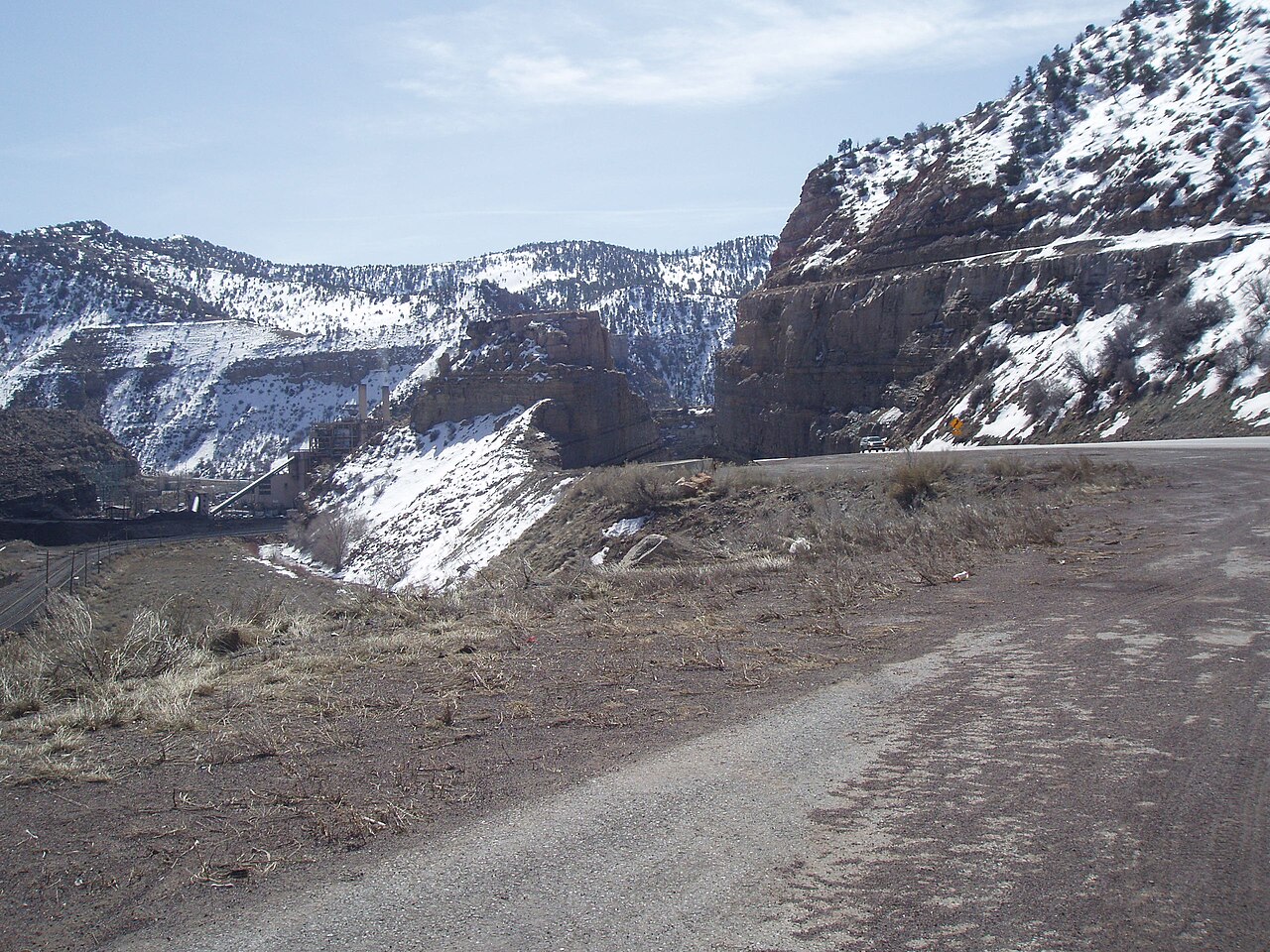
The Castle Gate formation today in Price Canyon: a single sandstone tower beside the highway where the western fin was blasted away.
The “gate” today — one sandstone tower survives beside US-6 where the western fin was blasted away in the 1960s. Tricia Simpson, 2008; Wikimedia Commons, CC BY-SA 4.0.
Plan your visit
Where It Is
Price Canyon along US-6, about 4 miles north-northwest of Helper, just south of the US-6/US-191 junction (roughly milepost 217.5–218).
The Memorials
A paved US-6 pullout holds the 1924 Mine Disaster Memorial (dedicated Oct. 3, 1987), the Cassidy robbery plaque, and a Carbon power-plant memorial.
The Cemetery
Castle Gate Cemetery sits on a hillside bench ~1.5–4.6 mi northeast of the junction, up a narrow dirt road off US-191; it holds disaster graves and a bronze memorial.
The Rock
From the pullout you can see the surviving eastern sandstone tower and, across the road, the 280-foot cut where its twin was removed.
Best Base
Helper (4 mi S): its historic district and the Western Mining & Railroad Museum are the best way to understand Castle Gate. Confirm museum hours first.
Managed By
A mix of UDOT right-of-way, Union Pacific, and private industrial owners — not a park. There is no visitor center on the townsite.
⚠ Active railroad and a high-speed canyon highway. The double-track line through Price Canyon is Union Pacific’s busy Central Corridor, carrying fast freight, heavy coal trains, and Amtrak’s California Zephyr — the right-of-way is private, trespassing is enforced, and you should assume every track is live and cross only at authorized crossings. US-6 is a fast canyon highway, not a scenic walking road: use an established pullout, never stop in a travel lane, and don’t try to reconstruct the old town by walking the shoulder or the tracks.
Stay out of the mines and off private ground. The old townsite and surrounding portals sit on private, industrial, and reclaimed mining land; the absence of a fence is not permission to explore. Utah’s Division of Oil, Gas and Mining warns that abandoned mines hide unstable roofs and portals, open shafts, and pockets of lethal or oxygen-poor air — its rule is simply stay out, stay alive. Keep to the cemetery, the recognized memorial pullout, public roads, and clearly public viewpoints unless you have explicit permission from the landowner.
The old Castle Gate townsite in Price Canyon, on US-6 about four miles north of Helper.

Nearby coal camps & historic sites

Helper
~4 mi S
The railroad service town just down-canyon and the best surviving built environment of the whole district. Its historic district and the Western Mining & Railroad Museum (with Cassidy’s salvaged store staircase) are the real way to understand Castle Gate. Still a living town.
Kenilworth
~7 mi E
A semi-inhabited, surprisingly intact 1908 coal camp on the cliffs above Helper, once linked underground to Castle Gate No. 2 by an electric haulage tunnel. Preserved company houses, store, and standing tipple works; 820 residents in 1920.
Standardville
~6 mi W · Spring Canyon
A “model” company town of 1912 with steam-heated housing and paved streets, now reinforced-concrete ruins, tipple footings, and ruined portals. Explore on legal roads only — and stay out of the mine workings.
Winter Quarters & Scofield
~18–24 mi NW
The Pleasant Valley Coal Company’s earliest camp and the site of the May 1, 1900 Winter Quarters explosion that killed about 200 men — then the worst coal disaster in the nation. The essential companion site to Castle Gate, with the Scofield cemetery and its mass memorials.
Storrs & Latuda
~5–8 mi W · Spring Canyon
Spring Canyon camps west of Helper: Storrs (founded by Jesse Knight as an alcohol-free town) and Latuda, with a notable Japanese-immigrant history (343 residents in 1920). Cut-stone ruins, portals, and rail grades — much of it private.
Sunnyside
~35 mi SE
A major Utah Fuel camp with a huge mine and coke-oven operation that once held more than 2,000 people; its long batteries of historic beehive coke ovens still stand. Now part of the East Carbon community — a surviving coal town, not a ruin.
Consumers
~14 mi SW, also on this site
A Gordon Creek coal camp that replaced mine cars with underground belts and was photographed by Dorothea Lange in 1936. Foundations and tipple footings on mixed public and private land.
National
~14 mi SW, also on this site
A small brick-and-concrete coal camp in Gordon Creek Canyon on the National Coal Railway, reopened after foreclosure and abandoned about 1950.

Also in the Carbon–Emery coal country: Hiawatha and Mohrland (~25–35 mi SW), with standing community buildings and massive steel rail bridges. For more ghost towns on the archive, see Terrace, Bodie, and Deadwood.

Further reading

Books, articles, archives & primary records
The Next Time We Strike: Labor in Utah’s Coal Fields, 1900–1933
Allan Kent Powell · Utah State University Press — the central academic account of Carbon County’s labor struggles, the UMWA, and the coal strikes.
A History of Carbon County
Ronald G. Watt · Utah Centennial County History Series — the civic, industrial, and community framework for Castle Gate and its neighbors.
Castle Valley, America: Hard Coal, Hard Times…, 1890–1929
Nancy J. Taniguchi · Utah State University Press — ties the D&RGW’s strategy to the social and political history of eastern Utah.
“One Long Day that Went on Forever” & the Castle Gate relief studies
Saline Hardee Fraser, Michael Katsanevas Jr., and Janeen Arnold Costa, in the Utah Historical Quarterly — eyewitness memory, the relief fund, and the widows’ long aftermath of 1924.
“The ‘Foreign Element’ and the 1903–4 Carbon County Coal Miners’ Strike”
Allan Kent Powell · Utah Historical Quarterly 43 (1975) — the key scholarly study of the immigrant miners and Mother Jones.
Castle Gate Relief Fund Committee records (Series 1207) & the 1897 robbery case file
Utah State Archives — committee minutes, family case records, and the grand-jury indictment that separates the robbery from the legend.
Castle Gate Coal Mines / Utah Fuel Company
UtahRails.net — a detailed railroad-and-mining chronology of the mines, owners, tipples, and the 1974 clearance.

Sources:

Utah Division of Archives and Records Service — “‘All Were Rattled’: Butch Cassidy, the Castle Gate Robbery, and the Wild West” and “Remembering the Castle Gate Mining Disaster,” plus the Castle Gate Relief Fund Committee inventory (Series 1207), archives.utah.gov.

Utah History to Go / Utah Historical Society — “Old King Coal,” “Mother Jones,” “The Scofield Mine Disaster,” and coal-era essays, historytogo.utah.gov.

UtahRails.net — “Castle Gate Coal Mines,” “Utah Fuel Company,” highway history, and the Castle Coal Country driving-tour guide, utahrails.net.

Legends of America, “Castle Gate, Utah – Coal Mining Queen”; Utah Life Magazine, “Castle Gate”; Carbon County UTGenWeb (Castle Gate mine-explosion rolls); “Carbon Power Plant,” Wikipedia. U.S. Census of Population, 1920–1950 (incorporated-place counts). Coordinates per Wikipedia / USGS.

Utah Division of Oil, Gas and Mining, “Stay Out, Stay Alive,” ogm.utah.gov; Union Pacific railroad-safety guidance.

Photo credits: Hero — “Castle Gate, Utah,” Detroit Publishing Co. (W. H. Jackson), c.1900, Library of Congress (LCCN 2008678078), public domain. Company house — “Home of John M. McPhie, miner…,” Russell Lee, 1946, U.S. National Archives (540547), public domain. Mine portal — “Portal of the mine, Utah Fuel Company, Castle Gate Mine,” Russell Lee, 1946, U.S. National Archives (540544), public domain. The gate today — Tricia Simpson, 2008, Wikimedia Commons, CC BY-SA 4.0.
← Explore more ghost towns

Similar Posts

Leave a Reply

Your email address will not be published. Required fields are marked *