Cisco, Utah
Utah
Railroad
The town the trains made · 1880s–1990s
14 min read
Founded
Rio Grande locomotive water stop ~1884; post office 1887 (unincorporated)
Peak Population
~200–250 around 1940 (approximate — see note)
County / Region
Grand County · Cisco Desert, between the Book Cliffs & the Colorado River
What Happened
Diesel engines ended the water stop; Interstate 70 bypassed the town in the 1970s
Still Standing
The Cisco Landing store, the 1887 post office & a 1923 cabin (restored), scattered ruins
Status
Near-ghost town — largely private, with active rail, oil leases, and an artist residency
Free — no admission fee
Reached from I-70 (Exit 214 or 204)
Private property — view from the road
Active rail corridor
Remote high desert — no services

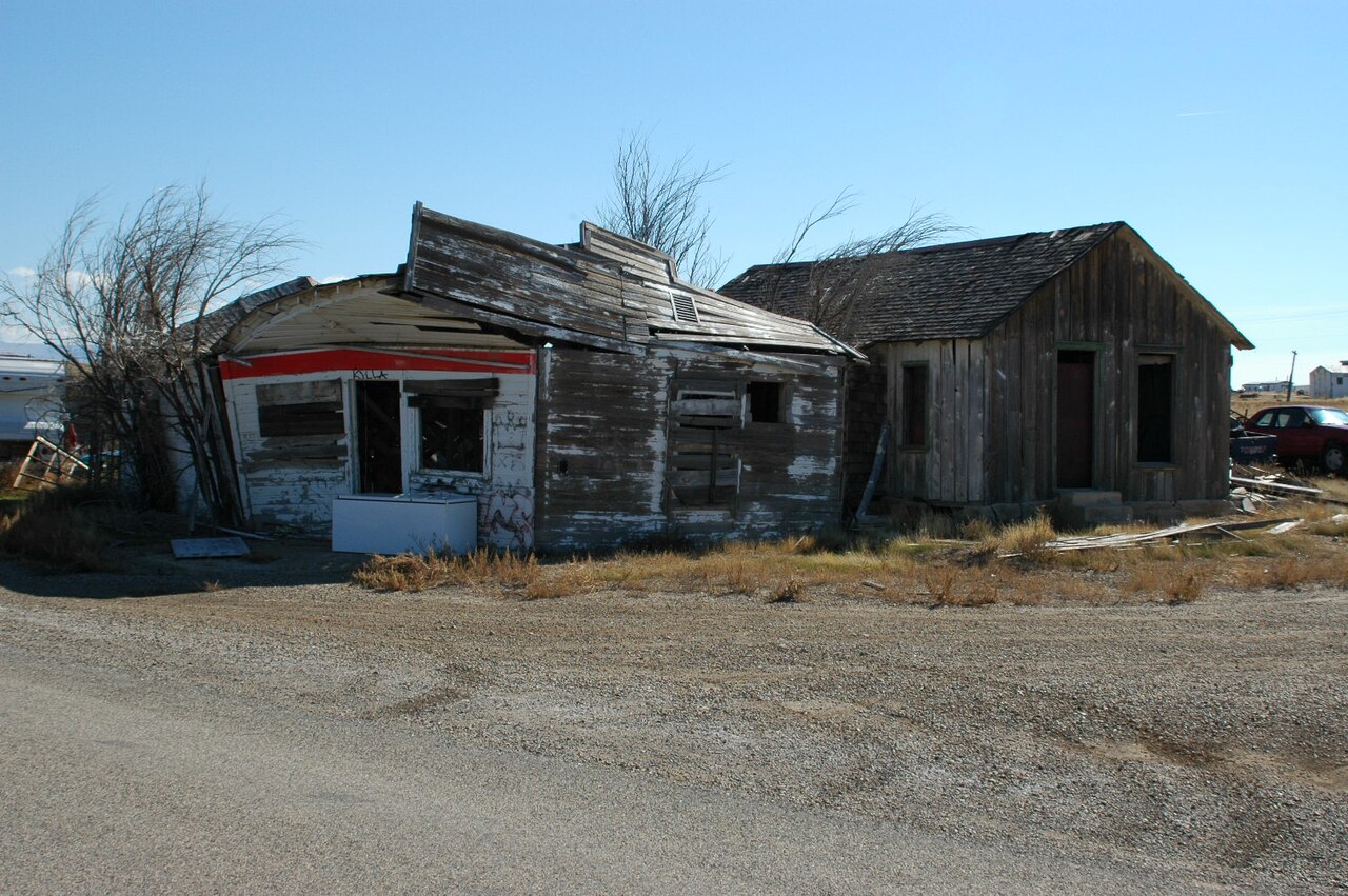
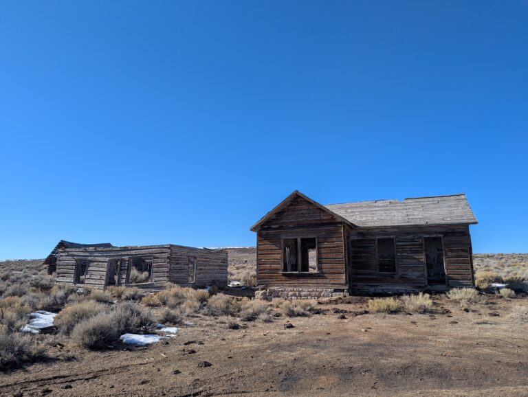
The weathered heart of Cisco — an old filling station and cabins beside the desert road. Photo: Kevin Delaney, Wikimedia Commons, CC BY 2.5.
Cisco is one of those Western ghost towns whose familiar roadside snapshot — a few gray buildings stranded between railroad tracks and empty desert — hides a far more interesting story. It was never a mining camp that played out or a single boom that went bust. It was a town invented by a railroad’s need for water in a bone-dry landscape, and over a century it reinvented itself again and again: locomotive water stop, livestock-shipping and sheep-shearing hub, oil-field service town, highway pit stop — and then, when the things that made it kept disappearing, a near-empty ruin that Hollywood and, lately, a handful of artists have claimed for their own.
And Cisco never quite vanished. Trains still thunder past on the main line, pumpjacks still nod in the surrounding oil field, part of the townsite is privately owned and lived on, and a small artist residency has spent the last decade stabilizing its old buildings rather than just photographing them. So the word “ghost town” here needs an asterisk. This is the documented history of Cisco, the famous stories worth separating from the record — including that Johnny Cash song — and how to see the place without trespassing on someone’s home.
The interstate, a former highway foreman recalled, is what finally “killed” Cisco — it bypassed the town by a couple of miles.
— A. J. Rogers, who worked on Interstate 70 in the 1970s, as told to High Country News
A town the railroad made out of water
Cisco exists because of steam locomotives and the lack of drinkable water. In the early 1880s the Denver & Rio Grande pushed its line across the Grand Valley of western Colorado into eastern Utah, and the dry country north of the Colorado River posed a hard problem: the groundwater, drawn through thousands of feet of Mancos Shale, was saline and alkaline — useless for a boiler. Because coal-fired steam engines needed to take on water every fifteen to twenty-five miles, especially before the long grades toward the Wasatch Plateau, the railroad had to build a dedicated servicing point in the Cisco Desert. Around 1884 it established Cisco as a water stop and telegraph point, hauling clean water in tank cars from the Colorado and Green rivers into cisterns beside the tracks, and later piping it in from Cisco Spring. A federal post office followed in 1887.
Cisco quickly became more than a tank beside the rails. It grew into a transfer point between a national east-west railroad and a roadless hinterland reached by wagon and livestock trail. Ranchers and miners from the La Sal Mountains and the Colorado and Dolores river country hauled wool, cattle, ore, and produce to Cisco (and neighboring Thompson) for shipment, and brought manufactured goods back out. When the Rio Grande rebuilt its original narrow-gauge line to standard gauge around 1890, the roadbed shifted about two miles, and the little settlement simply picked up its houses and shops and followed the rails to stay beside them.
Was Cisco really a “D&RGW town”? More or less — but the name compresses a tangle of corporate history. The route everyone calls the Denver & Rio Grande Western went through several names and reorganizations; nineteenth-century timetables place Cisco first on the original narrow-gauge Rio Grande line west of Grand Junction, which was later rebuilt to standard gauge and only eventually became the D&RGW that twentieth-century residents knew. Calling Cisco a “D&RGW town” is a reasonable shorthand, not a precise statement of which company built it.
Sheep, cattle, and a surprisingly mixed community
Beyond its machinery, Cisco became a serious livestock town. The Book Cliffs to the north gave summer pasture and the saltbush flats of the Cisco Desert gave winter range, and the settlement turned into a shipping and shearing hub. Pastoral outfits — most notably the Uinta Sheep Shearing Association — built large powered shearing corrals and dipping vats beside the sidings, where crews said to handle up to 100,000 head each spring compressed the wool into long burlap sacks stacked along the right-of-way. The annual Cisco wool clip was reported as one of the largest single gathering points in Utah.
That working economy drew a more varied population than the empty ruins suggest today. Railroad and labor crews and the shearing outfits brought Basque, Mexican, and Native American workers, and the town’s wider history records Italian, Chinese, Japanese, and African American railroad labor as well. None of this should be romanticized — the best-researched account cautions that social life here was probably segregated rather than some frontier melting pot — but the real Cisco was far more mixed, and far more about railroads and sheep than the stereotypical single-industry mining camp.
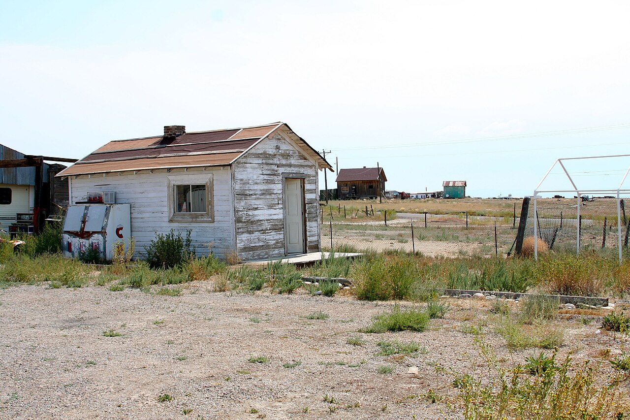
“Downtown” Cisco — a compact scatter of wood-frame buildings on the desert flat, the Book Cliffs country beyond. Photo: GerthMichael, Wikimedia Commons, CC BY-SA 3.0.
How big did Cisco actually get? Smaller than the legends imply. The best-supported figure is roughly 200–250 residents around 1940, and even that should be read as an approximate community estimate, not a precise census count. Cisco was unincorporated, so federal enumeration lumped it into a larger surrounding precinct — which is exactly why different popular histories quote slightly different round numbers. “About 250 at or around 1940” is the strongest sourced way to put it; a confident exact “peak population” is not really available for a place like this.
Oil, uranium, and the highway years
Railroad and livestock money was soon joined by petroleum. In September 1924, drillers working the Cisco Dome — a geological fold northeast of town — struck high-pressure natural gas and light crude at shallow depths of two to three thousand feet, opening the Cisco oil and gas field. The shallow, low-cost deposits made Cisco one of the earliest sustained oil-producing zones in eastern Utah, and field activity, storage tanks, and pipelines tied into the rail spurs. At the same time the road through town was folded into the transcontinental routing of U.S. Routes 6 and 50, one of the few paved arteries across the Colorado Plateau, and after World War II Cisco’s garages and filling stations — places like Ray Scott’s garage and H. Ballard Harris’s roadside station — did a brisk business fueling and patching up cross-country motorists.
Two myths to retire: the “oil metropolis” and the “uranium town.” Cisco-area oil and gas became locally important in the 1920s and kept the district alive intermittently for decades — but popular accounts that make 1924 Cisco into Utah’s dominant petroleum city overshoot badly; the deposits were shallow and modest, never Texas- or California-scale. And while geologist Charlie Steen was living in rough quarters at Cisco in 1952 when he was prospecting the Colorado Plateau, his era-defining Mi Vida uranium strike was in Lisbon Valley south of Moab — not at Cisco. Cisco was his base just before the discovery, which is a great footnote, but it does not make Cisco a uranium town.
Bypassed twice: dieselization and the interstate
Cisco’s first technological blow fell on the thing that created it. As the Rio Grande converted from steam to diesel-electric power across its mountain divisions between roughly 1948 and 1956, locomotives stopped needing water — and a town built specifically to water them lost its reason to exist. The railroad pulled its storage towers, cut its maintenance staff, and closed its local facilities. For a while the highway economy carried Cisco anyway: as long as east-west motorists rolled through on old US-6/50, the cafés, garages, and gas stations survived. A Thompson Springs resident remembered driving to Cisco’s café to shoot pool and drink beer as late as 1970.
The second blow was decisive. When Interstate 70 was built across an elevated bench a mile or two north in the late 1960s and early 1970s, it stripped the through traffic away for good, and the roadside businesses collapsed almost at once. The school closed and its children were bused to Thompson Springs or Green River; storefronts shuttered one by one. By the 1980s, tax foreclosures swept the townsite and Grand County took about 80.5 acres for delinquent taxes — and an outside proposal to put a hazardous-waste incinerator on that cheap desert land sparked a countywide fight before voters killed it in 1988. In the 1990s the post office closed and ZIP code 84515 was retired, and with no residents to guard them, the empty buildings were steadily stripped by vandals and souvenir hunters.
When exactly did I-70 “kill” Cisco? The clearest account we have is a memory, not a project file. A former Utah highway foreman, A. J. Rogers, recalled working seasonally on I-70 around 1973 and described the interstate as the thing that finally killed Cisco by bypassing it a couple of miles away. That makes the early-to-mid 1970s the right window — but because it comes from a participant’s recollection rather than a formal UDOT completion chronology, treat it as documented oral history of the construction era, not proof that one specific segment opened on one exact date.
The famous stories: Johnny Cash, Thelma & Louise, and Vanishing Point
For a town this small, Cisco has an outsized place in American pop culture — and the stories vary a lot in how well they hold up. Two are firmly documented. The 1971 cult road film Vanishing Point shot its climactic crash here in July 1970; rather than wreck one of its hero Dodge Challengers, the crew gutted a 1967 Camaro, painted it silver to match, loaded it, and towed it on a cable at about 45 mph straight into two parked Caterpillar D8 bulldozers. Two decades later, Ridley Scott used Cisco’s deteriorating buildings for sequences in Thelma & Louise (filmed in the summer of 1990), including a hideout by the tracks and a call from a ruined filling station, and cast a real local — opal miner Dan “Ernie” Vanover — in a cameo. The town turned up again in Wim Wenders’s 2005 Western Don’t Come Knocking. The one caution: claims pinning a specific surviving building as the exact “Vanishing Point gas station” are far more common in travel blogs than in any production record, so enjoy the town-level film history and be skeptical of building-by-building identifications.
Did Johnny Cash really write his filling-station song about Cisco? This is where ghost-town lore has outrun the evidence. Cash genuinely wrote and recorded “Cisco Clifton’s Fillin’ Station,” a ballad about an old-style station man whose livelihood is ruined when an interstate bypasses him — and Cisco, Utah really was bypassed by an interstate, so the match is irresistible. Local tradition holds that Cash stopped for gas here, met station man H. Ballard Harris, and wrote the song about him. But Cash’s own official material frames “Cisco Clifton” as a type of person, and his album commentary says the interstates bypass places “like” Cisco Clifton’s station — it never names this town or a specific resident. The song is also dated to 1967, before the I-70 construction usually blamed for Cisco’s decline. The thematic parallel is real; a direct, one-to-one identification with Cisco, Utah is roadside tradition unless a Cash manuscript or interview turns up to prove it.
The Wild-West tales — and Ted Bundy. Cisco has collected a thick layer of oral mythology: a bootlegger who supposedly hid liquor where a male sheriff wouldn’t search, an oil well allegedly concealed inside a building, stories of bodies dumped in the desert, and a tale that Ted Bundy once walked into a Cisco establishment and promptly left after seeing armed locals. The researchers who gathered these from residents were explicit that it’s hard to separate Cisco’s authentic rough history from apocryphal storytelling, and no independent archival or law-enforcement record was found for the Bundy encounter or the body-dumping stories. They’re worth telling — as “residents later recalled,” not as established fact.
A ghost town with an asterisk: the artist era
Cisco’s most recent chapter is also one of its best documented. Beginning around 2015, artist Eileen Muza bought up cheap parcels of the abandoned townsite and settled in, and rather than simply photographing ruins she used salvage and vernacular materials to stabilize the old buildings — among them the 1887 post office and a 1923 log cabin. Around 2018 she formally launched Home of the Brave, an off-grid artist-in-residence program inviting painters, sculptors, and photographers to spend weeks living and working in the desert. In December 2024 she sold the compound to another artist, who has continued it as the Cisco Artist Residency; by May 2026 it was reported as an active residency in a town of about two people.
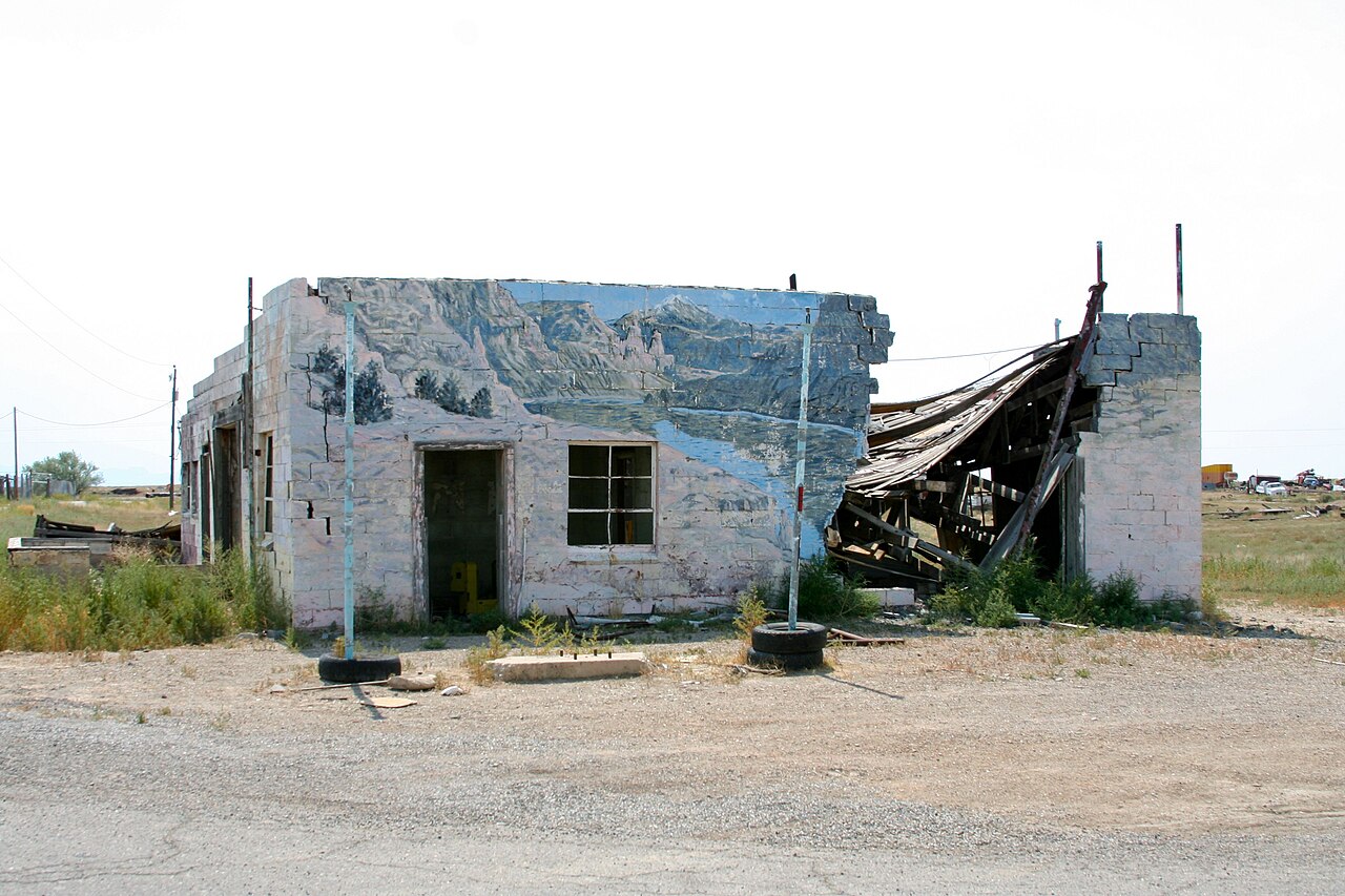
A former Cisco roadhouse, its block walls painted with a desert mural and its canopy collapsed — the kind of structure the artist residency has worked to stabilize. Photo: GerthMichael, Wikimedia Commons, CC BY-SA 3.0.
A note on names. Accounts of the 2024 handoff differ on the details: the most carefully sourced reports name the new owner as Kara Bard, continuing the project as the Cisco Artist Residency, while other write-ups give the successor’s name differently and say the program was being rebranded (as “Held Horizon”). What’s not in dispute is the substance — the residency changed hands in late 2024 and continues as an active, privately owned preservation-and-art project. If you’re planning a visit, treat the whole townsite as occupied and private.
Timeline
1883
The Rio Grande’s narrow-gauge line crosses the Grand Valley into eastern Utah.
1884
Cisco is established as a locomotive water stop and telegraph point; water is hauled in by tank car.
1887
A federal post office is chartered at Cisco.
~1890
The line is rebuilt to standard gauge; the roadbed shifts ~2 miles and the town follows the rails.
1890s–1920s
Cisco becomes a livestock-shipping and large-scale sheep-shearing hub.
1924
Drillers strike oil and gas at the Cisco Dome; a petroleum era begins.
~1930s–40s
The US-6/50 highway era; Cisco peaks at roughly 200–250 residents.
1948–56
The Rio Grande dieselizes; the water stop loses its purpose.
1952
Charlie Steen bases at Cisco before his Mi Vida uranium strike near Moab.
1967–68
Johnny Cash records “Cisco Clifton’s Fillin’ Station” for From Sea to Shining Sea.
1970
Vanishing Point films its fiery crash sequence at Cisco.
early 1970s
Interstate 70 bypasses Cisco by a mile or two; the roadside businesses collapse.
1988
Grand County voters reject a hazardous-waste incinerator on tax-forfeited Cisco land.
1990
Thelma & Louise films at Cisco; the post office and ZIP 84515 close that decade.
~2015–24
Eileen Muza’s Home of the Brave restores buildings and runs an artist residency.
2024–26
The compound changes hands and continues as the Cisco Artist Residency.
Seeing Cisco now
A good Cisco visit is really a roadside historical-landscape visit: you come to look and photograph from public ground, not to wander through buildings. There’s no gate, no fee, and no museum — but there’s also no single “ghost town” you’re free to explore, because the townsite is a patchwork of private parcels, oil leases, BLM and state-trust land, and an active railroad. The surviving fabric is genuinely worth the detour: the Cisco Landing store built of stacked, creosote-soaked railroad ties; the restored 1887 post office and 1923 cabin of the artist compound; and all around them the skeletal frames of mid-century filling stations, collapsed houses, open cellars, and rusting cars, with pumpjacks still working the field beyond.
Plan your visit
Where It Is
Grand County high desert, about 46 miles northeast of Moab, between the Book Cliffs and the Colorado River.
Getting There
From I-70, take Exit 214 (the BLM-recommended Cisco approach) or Exit 204 (the SR-128 scenic-byway terminus), then follow Old Cisco Highway — historic US-6/50.
Fees
No admission fee; Cisco is not a park or ticketed attraction. Nearby BLM campgrounds may charge their own fees.
What’s There
The railroad-tie Cisco Landing store, the restored post office & cabin (private), scattered ruins, and working oil pumpjacks.
Best Pairing
Thompson Springs and Sego Canyon — the same boom-and-bypass story plus a coal ghost town and a managed rock-art site.
Managed By
No single manager — fragmented private, BLM (Moab Field Office), and state land. Use Grand County’s parcel viewer to check ownership.
⚠ Active railroad and unstable ruins. The tracks on Cisco’s south edge are Union Pacific’s busy Central Corridor — fast freight and Amtrak’s California Zephyr — and the right-of-way is private: never walk the rails for a photo, cross only at authorized crossings, and assume a train can come from either direction with little warning. The buildings themselves are deteriorated, with sagging roofs, rotten joists, protruding square nails, and old lead paint and asbestos; staying outside them is both the safest and the most legal choice. This is remote high desert, too — summer heat tops 100°F, there’s no water, food, or fuel, and rattlesnakes, black widows, and hantavirus-carrying deer mice all turn up in the ruins. Carry your own water and watch the weather; wet Mancos clay turns dirt tracks to impassable gumbo.
It’s private property — look, don’t take. An open doorway, a collapsed fence, or a building that looks abandoned is not permission to enter; most structures and land around Cisco are privately owned, and Utah trespass law applies. Photograph from public roads and obvious public roadside areas, leave every artifact — glass insulators, square nails, timbers — exactly where it lies, add no graffiti and take no “souvenirs,” and on the surrounding BLM land stay on established roads rather than cutting new tracks. The townsite is inhabited; treat it as someone’s home, because it is.
The Cisco townsite on Old Cisco Highway, Grand County, reached from I-70 Exits 214 or 204.
Nearby ghost towns & historic sites
Thompson Springs
~21 mi W
Cisco’s twin — the other Rio Grande water-and-shipping stop, the region’s main cattle-loading point, and the railhead for coal from Sego. Not fully abandoned: ruined storefronts and motels beside the active main line. Respect occupied property.
Sego & Sego Canyon
~26 mi NW
A coal-company ghost town (American Fuel Co., 1911–1955) north of Thompson, with a standing two-story stone store and wooden tipple ruins. The BLM’s Sego Canyon site adds Fremont, Ute, and Barrier Canyon rock art — don’t touch the panels.
Dewey Bridge
~14 mi S
The historic Colorado River crossing that Cisco’s railhead served. The 1916 wooden suspension bridge — once Utah’s longest — burned in 2008, but the stone anchorages and towers remain, with a BLM campground and river put-in for public access.
Westwater
~16 mi E
A Rio Grande siding east of Cisco on the same line, now better known for Westwater Canyon than for buildings. The BLM manages it for wilderness and whitewater; the canyon’s Class III–IV river trips require a permit.
Castleton & Miners Basin
~32 mi S · La Sals
High-country gold, silver, and copper camps in the La Sal Mountains, worked in the 1880s–1910s and long abandoned. Cabin ruins, stone foundations, and old adits among the aspens — the mineral counterpart to Cisco’s transport story.
Loma & Mack, Colorado
~35–40 mi E
Living Grand Valley towns on the same corridor, not ghost towns — but Mack was the terminal of the Uintah Railway, and both keep historic railbeds and irrigation works. Loma is the trailhead for the BLM’s 142-mile Kokopelli’s Trail to Moab.
Moab (~46 mi S) makes the natural base, and ties into Cisco’s story through Charlie Steen’s uranium strike. For more ghost towns on the archive, see Terrace, Silver Reef, and Bodie.
Further reading
Books, articles, archives & primary records
A History of Grand County
Richard A. Firmage · Utah Centennial County History Series (Utah State Historical Society & Grand County, 1996) — the essential county history, covering the D&RGW line, the stock trails, the 1924 oil boom, and the I-70 bypass.
“Richard Dallin Westwood: Sheriff and Ferryman of Early Grand County”
J. M. Westwood · Utah Historical Quarterly — concrete period detail on Thompson and Cisco as cattle-shipping points and on wagon-hauled ore reaching the railroad.
“Memories of Cisco”
Mary Cowger Hepperle · Canyon Legacy No. 51 (Moab Museum, 2004) — a first-person memoir of mid-century Cisco: cistern upkeep, railroad families, machine shops, and the Cisco Landing store.
Grand Memories
Daughters of Utah Pioneers, Grand County Chapter (1972) — pioneer journals and oral histories of sheep-shearing, water-hauling, and the desert school.
“A History of Dewey, Utah”
Herm Hoops · Canyon Country Zephyr (2018) — the ferry, King’s Toll Road, and the 1916 Dewey suspension bridge, and how the Cisco railhead tied the river country to the national network.
Petroleum Geology of the Cisco Dome Area, Grand County, Utah
Craig D. Morgan · Utah Geological Survey (1999) — the technical authority on the shallow reservoirs behind Cisco’s oil-and-gas history.
“The Pioneer of Ruin” & the Grand County Scenic Byways plan
High Country News (Eileen Muza / Cisco feature) and Grand County’s Corridor Management Plan — the best modern synthesis of late-Cisco social history, the I-70 transition, and the water-stop-to-artist-outpost arc.
Sources:
Grand County Scenic Byways Corridor Management Plan — railroad-water function, livestock economy, 1924 petroleum, film history, and the US-6/50-to-interstate transition, grandcountyutah.net.
“Ghost Towns: Cisco,” Beehive Archive — Utah Humanities, stories.utahhumanities.org; “The Pioneer of Ruin,” High Country News (Cisco / Eileen Muza feature), hcn.org.
Cisco, Utah Townsite — Preservation Utah, preservationutah.org; “Thelma & Louise: 30 Years Later,” Utah Film Commission, film.utah.gov; “Cisco Clifton’s Fillin’ Station,” Johnny Cash Official Site, johnnycash.com.
Cisco Takeout / BLM directions & land maps, blm.gov; Grand County Parcel Viewer; Union Pacific railroad-safety guidance; Craig D. Morgan, Petroleum Geology of the Cisco Dome Area (Utah Geological Survey); Richard A. Firmage, A History of Grand County; UtahRails D&RGW station history. Coordinates per Wikipedia.
Photo credits: Hero — “Cisco, Utah,” Kevin Delaney, Wikimedia Commons, CC BY 2.5. “Downtown Cisco” and “former Resthouse at Cisco” — GerthMichael, Wikimedia Commons, CC BY-SA 3.0. All used with attribution per their licenses.
← Explore more ghost towns