Black-and-white photo of an abandoned log saloon with a sagging, partly collapsed roof and open doorways, in a grassy clearing ringed by spruce trees below bare mountain slopes

Hancock, Colorado: The Railroad Camp Below the Alpine Tunnel
Quick facts
What it is1880s railroad camp, now foundations and log remnants
Founded1880, on the Hancock Placer claim
Peak populationAbout 200 (1881)
Post office1880 to 1887, again 1903 to 1904
RailroadDenver, South Park & Pacific, 1881 to 1910
ElevationAbout 11,000 feet
Coordinates38.6403° N, 106.3659° W
LandPike-San Isabel National Forest
CountyChaffee County
StateColorado
⚠ Rough dirt road · Snow-free only in summer · No services · Old mine workings and private claims nearby · Afternoon lightning
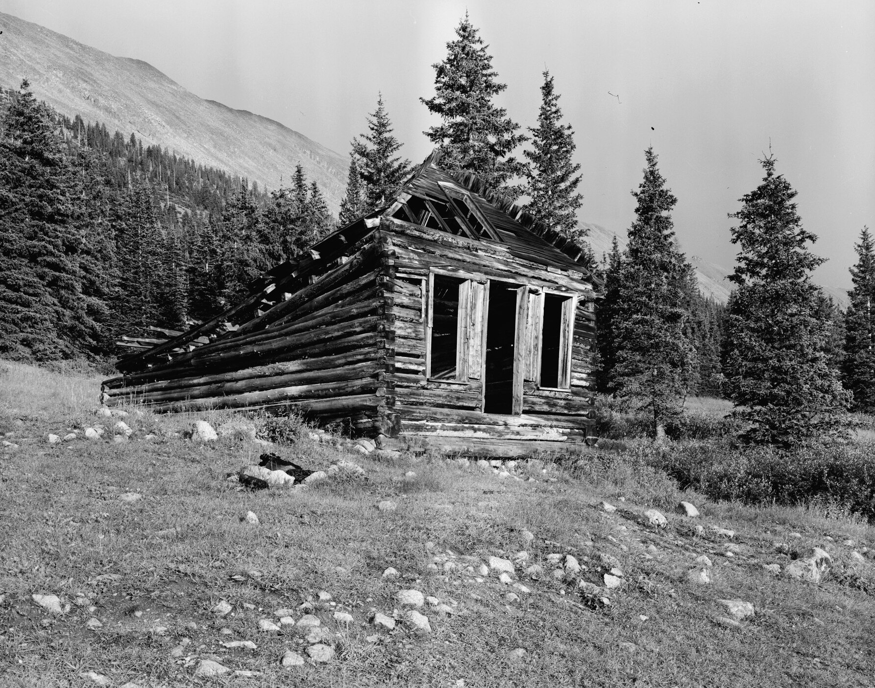
Black-and-white photo of an abandoned log saloon with a sagging, partly collapsed roof and open doorways, in a grassy clearing ringed by spruce trees below bare mountain slopes
The ruined log saloon at Hancock, photographed for the Historic American Buildings Survey (undated). Today only its lowest log courses remain. Photo: Historic American Buildings Survey, Library of Congress, public domain.

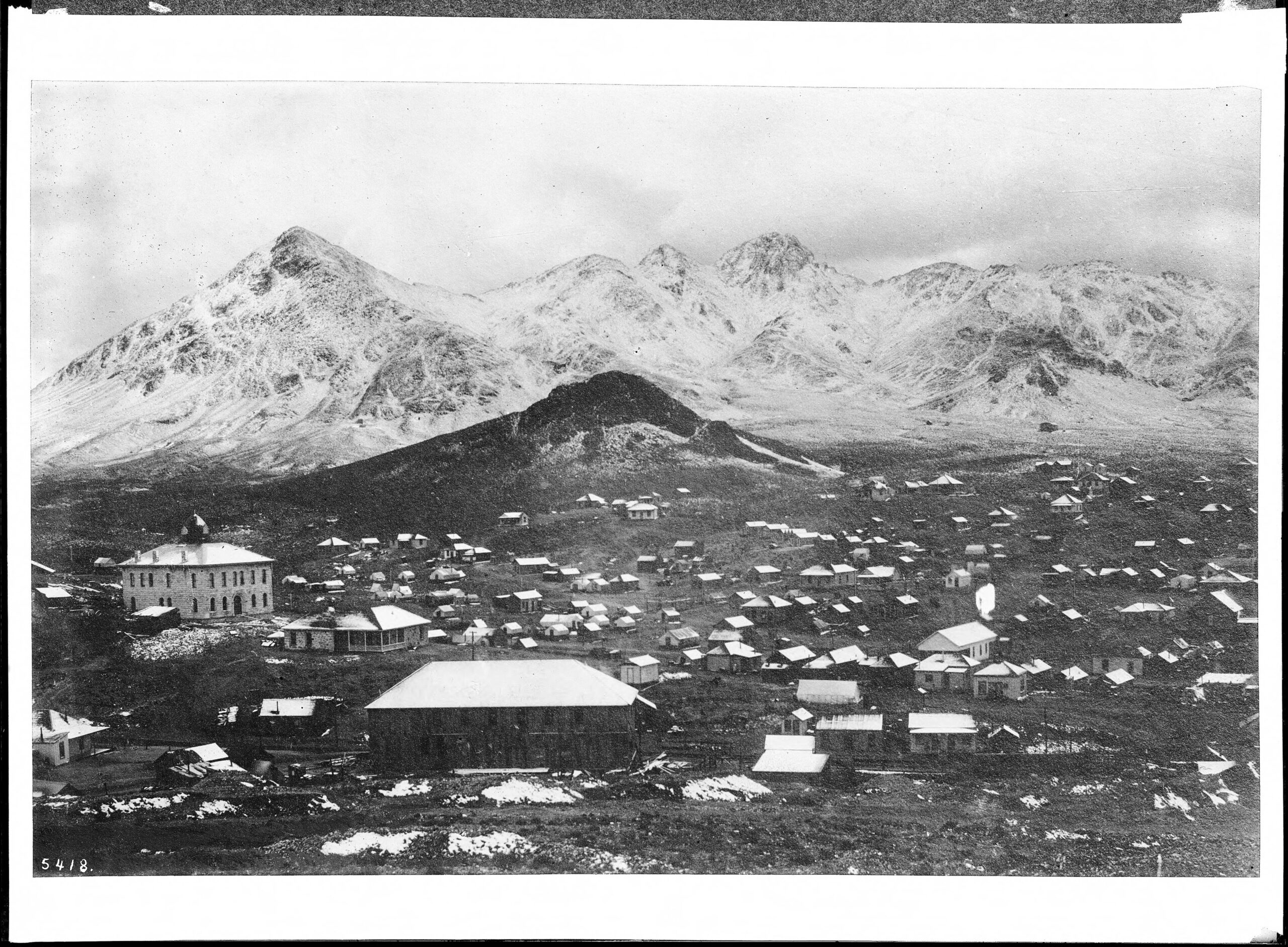
Hancock was the last town on the Denver, South Park & Pacific Railroad before the Continental Divide, a camp at about 11,000 feet at the head of Chalk Creek. It grew up in 1880 and 1881 while crews bored the Alpine Tunnel through the mountain above it, and for a few months it was the end of the track, where freight came off the cars and went over Hancock Pass by wagon. Once trains began running through the tunnel in 1882, Hancock became a quiet stop with a water tank, and by 1887 its depot had been hauled away and its post office closed. The railroad kept passing through until 1910, then left for good. Today Hancock is a row of cellar holes, scattered foundations and the bottom logs of a saloon, and the trailhead for a 2.8-mile walk to the tunnel’s caved-in east portal.

A camp on the Hancock Placer

The upper Chalk Creek valley filled with prospectors in the late 1870s, and towns sprang up down the canyon at Alpine, St. Elmo and Romley. Hancock began in 1880 on a placer claim called the Hancock Placer, near the top of the valley. Its owners formed the Hancock Town Company, platted the ground into lots and sold them to people who expected the railroad to come through.

They were right. The Denver, South Park & Pacific had chosen Chalk Creek as its road west to the Gunnison Country, and Hancock sat at the foot of the mountain the railroad meant to tunnel under. A post office opened on September 10, 1880.

On the name and the founders: Most sources say the town took its name from the Hancock Placer. Some accounts say it honored General Winfield Scott Hancock, the Democratic candidate for president in 1880, and some name four prospectors as the founders. We could not confirm either from records, so treat them as unproven.

The railroad war that built Hancock

Two railroads were racing to reach the silver camps of Leadville and the Gunnison Country, the Denver, South Park & Pacific and the Denver & Rio Grande. Under pressure from financier Jay Gould, they signed a joint operating agreement on October 1, 1879. The Rio Grande would build north to Leadville, the South Park line would build west through Chalk Creek toward Gunnison, and each would have rights on the other’s new track.

The South Park line pushed up the canyon on a shelf cut above the creek and reached St. Elmo at the end of 1880. In 1881 the rails arrived at Hancock. For a few months it was the railhead for the whole western push: freight, rails, machinery and supplies came off the narrow-gauge cars here and were hauled by wagon over Hancock Pass, at more than 12,000 feet, while crews worked on the tunnel above.

The town filled out quickly. By 1881 about 200 people lived there, with stores, restaurants, at least one hotel, saloons and two sawmills that cut timber for the railroad. The railroad built a depot, a section house, a water tank and a coal platform.

On the population: Some modern retellings say 1,000 to 1,500 people lived at Hancock while the tunnel was being dug. We found no reliable source for that, and every documented figure is about 200. Construction crews may have camped in the area without being counted as town residents.

The Alpine Tunnel

The railroad’s chief engineer, James A. Evans, chose to go under the Continental Divide at Altman Pass, later renamed Alpine Pass, rather than over it. Work started in January 1880. The first contractor, Cummings & Co., was replaced that summer by Fitzgerald, Cushing & Osborn, and crews blasted from both ends through broken, crumbling rock that would not hold its shape.

The two headings met on July 26, 1881. The finished bore was about 1,772 feet long, 12 feet wide and 17 feet high, and at about 11,523 feet it was the highest railroad tunnel in North America at the time. The loose rock had to be lined with heavy California redwood timbers, cut 12 inches square and shipped in by the hundreds of thousands of board feet. Track reached the east portal that October, and the first train ran through in July 1882.
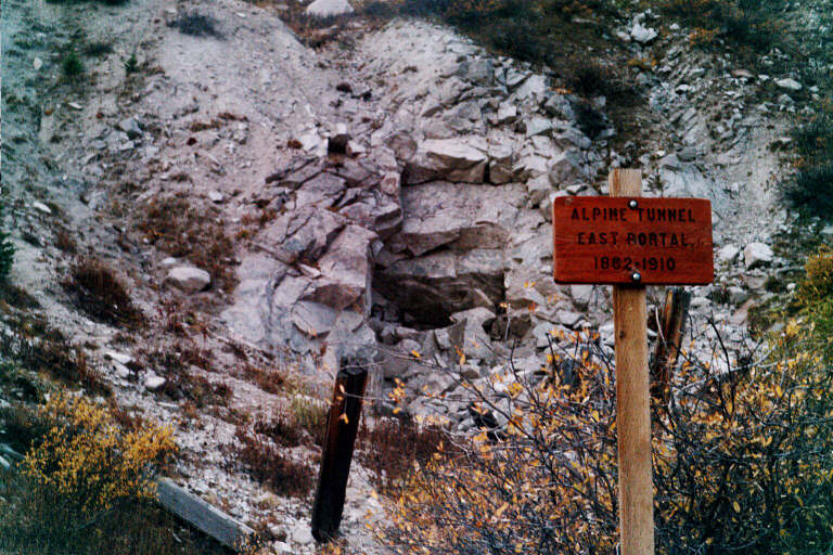
Collapsed rock slope where the east portal of the Alpine Tunnel once opened, with a red sign reading Alpine Tunnel East Portal 1881-1910
The east portal today: a slope of fallen rock and a sign. The tunnel is sealed by cave-ins at both ends.Photo: Tim Dennehey, 2001, CC BY-SA 3.0, via Wikimedia Commons

The tunnel was a feat of engineering and a poor investment. The South Park line reached Gunnison in September 1882, more than a year after the Rio Grande had already arrived over Marshall Pass. Snow buried the approaches every winter, and keeping trains moving at 11,000 feet cost far more than the traffic paid.

On the west side of the divide the grade clung to a cliff at a spot called the Palisades, held up by a dry-laid stone wall about 450 feet long and 33 feet high, fitted by hand without mortar. Below it, at the section camp of Woodstock, an avalanche on March 10, 1884, killed 13 people, including all six children of boardinghouse keeper Marcella Doyle.
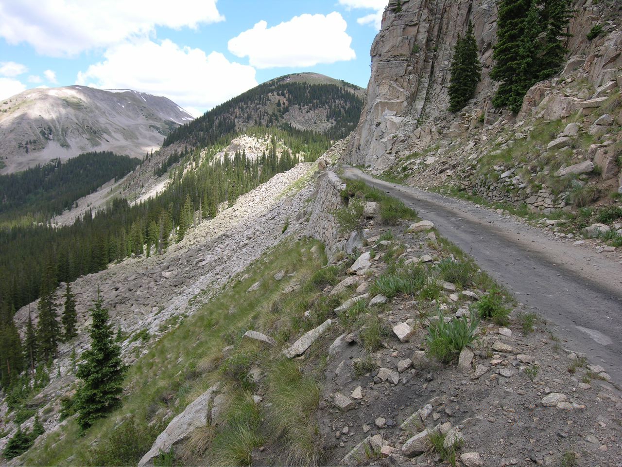
Old railroad grade, now a narrow gravel road, curving along the base of a sheer rock cliff high above a forested valley
The grade at the Palisades, west of the tunnel.Photo: A.L. Szalanski, 2006, CC BY-SA 3.0, via Wikimedia Commons
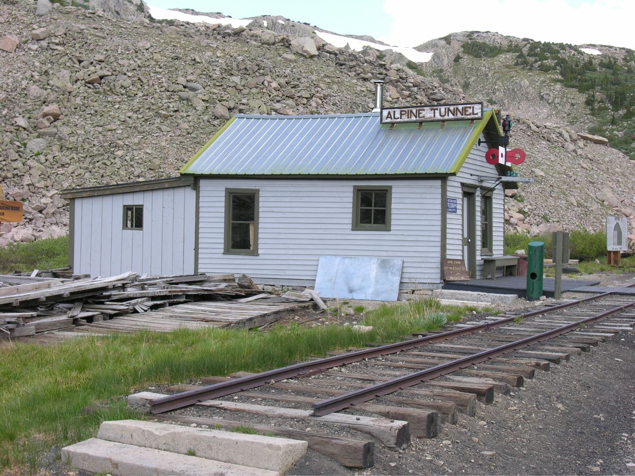
Small restored white wooden telegraph office with an Alpine Tunnel sign beside a short stretch of narrow-gauge track, below rocky slopes with patches of snow
The restored 1883 telegraph office at Alpine Station.Photo: A.L. Szalanski, 2006, CC BY-SA 3.0, via Wikimedia Commons
On the tunnel’s numbers: Sources give the length as anywhere from about 1,772 to 1,845 feet, the cost as $242,000 to $300,000, and the high point as 11,523 to 11,612 feet. We use the most widely cited figures. Some retellings also say Italian stonemasons built the Palisades wall; no source we found names the builders.

Mines of the upper Chalk Creek

The railroad was Hancock’s reason to exist, but the mines kept trains running up the canyon. The biggest was the Mary Murphy, found in the 1870s above Romley, a couple of miles down the valley. By federal figures it produced about 220,000 ounces of gold, worth about $4.4 million at the time, along with silver, lead and zinc. Aerial trams carried its ore down to the tracks at Romley.

Closer to Hancock, the Allie Belle and the Flora Belle mines built ore chutes right beside the grade, so ore could drop straight into waiting cars. The Stonewall, found in 1879, was another early producer.
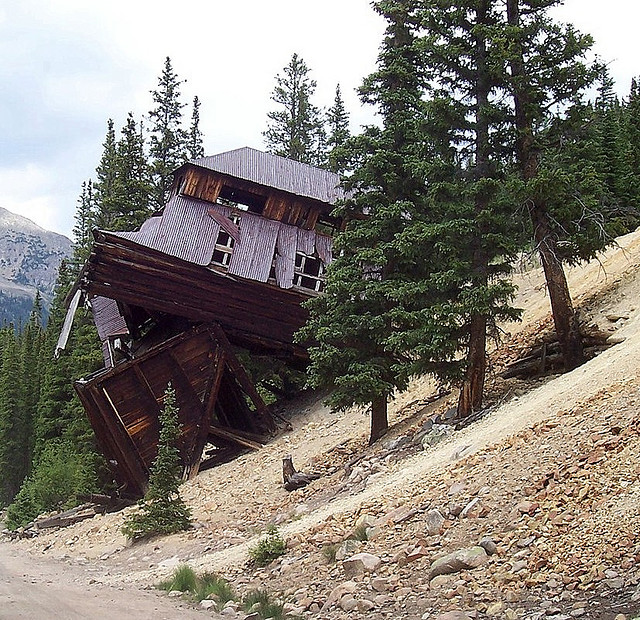
Weathered wooden tram terminal building leaning sharply downhill on a rocky slope among spruce trees
The leaning lower terminal of the tram that brought Mary Murphy ore down to the railroad at Romley.Photo: John Holm, 2007, CC BY 2.0, via Wikimedia Commons

The mining left a long cleanup behind. Water draining from old workings carried zinc and cadmium into Chalk Creek, and in 1986 about 800,000 young trout died at a state fish-rearing unit downstream, a kill blamed on drainage from the Mary Murphy. State and federal agencies have worked on the old mine sites since.

On the Mary Murphy’s output: Figures of $14 million to more than $60 million circulate online, but we found no source for them. The $4.4 million figure comes from a U.S. Geological Survey report and counts gold at the prices of the day.

A short boom, a long fade

Hancock’s best year was its first. Once the tunnel opened, freight no longer stopped here, and the town shrank to a water stop and a few families. In 1887 the railroad took the depot apart and moved it down the line to Romley, and the post office closed on June 24 of that year.

In 1888 a cave-in inside the tunnel shut it down, and for seven years trains to Gunnison ran over the Rio Grande instead. The bankrupt South Park line was sold in 1889 and became the Denver, Leadville & Gunnison, and at the end of 1898 it was folded into the Colorado & Southern. The tunnel reopened in 1895, but not without cost: in June of that year four men died of carbon monoxide from a locomotive inside the bore while it was being cleared.

The Silver Panic of 1893 hit the whole district, though the Mary Murphy’s gold kept Chalk Creek working. Hancock even got its post office back from 1903 to 1904. Then in October 1910 the tunnel caved in again, and the Colorado & Southern gave up on it. The last locomotive came through in November 1910.

On deaths in the tunnel: Some accounts say four or five workers suffocated in a cave-in in 1910. The deaths we could document happened in June 1895, when the tunnel was being reopened. We found no record of a 1910 death toll, or of a 1902 landslide said to have destroyed most of Hancock.

Trains still ran up the canyon to the mines for a few more years. The rails from the tunnel down through Hancock were pulled up between 1923 and 1926, the last freight passed Hancock in 1924, and by 1926 the whole Chalk Creek branch was gone.

What remains

Very little of the town itself survives. Look for a row of cellar depressions, stone foundations, old dumps of cans and glass, and the lowest log courses of a saloon that still stood with its walls up when it was photographed for the Historic American Buildings Survey. Forest Service signs explain the site. Down the road toward St. Elmo you pass the deteriorating ore bin and chute of the Allie Belle beside the grade.

The railroad is easier to see than the town. The old grade runs past Hancock and up the valley, and since 1996 the line from Hancock across the divide to Quartz has been on the National Register of Historic Places as the Alpine Tunnel Historic District, with parts of Hancock counted as contributing features. On the far side of the divide, volunteers have restored the 1883 telegraph office at Alpine Station, along with its platform, a turntable and a short stretch of track.
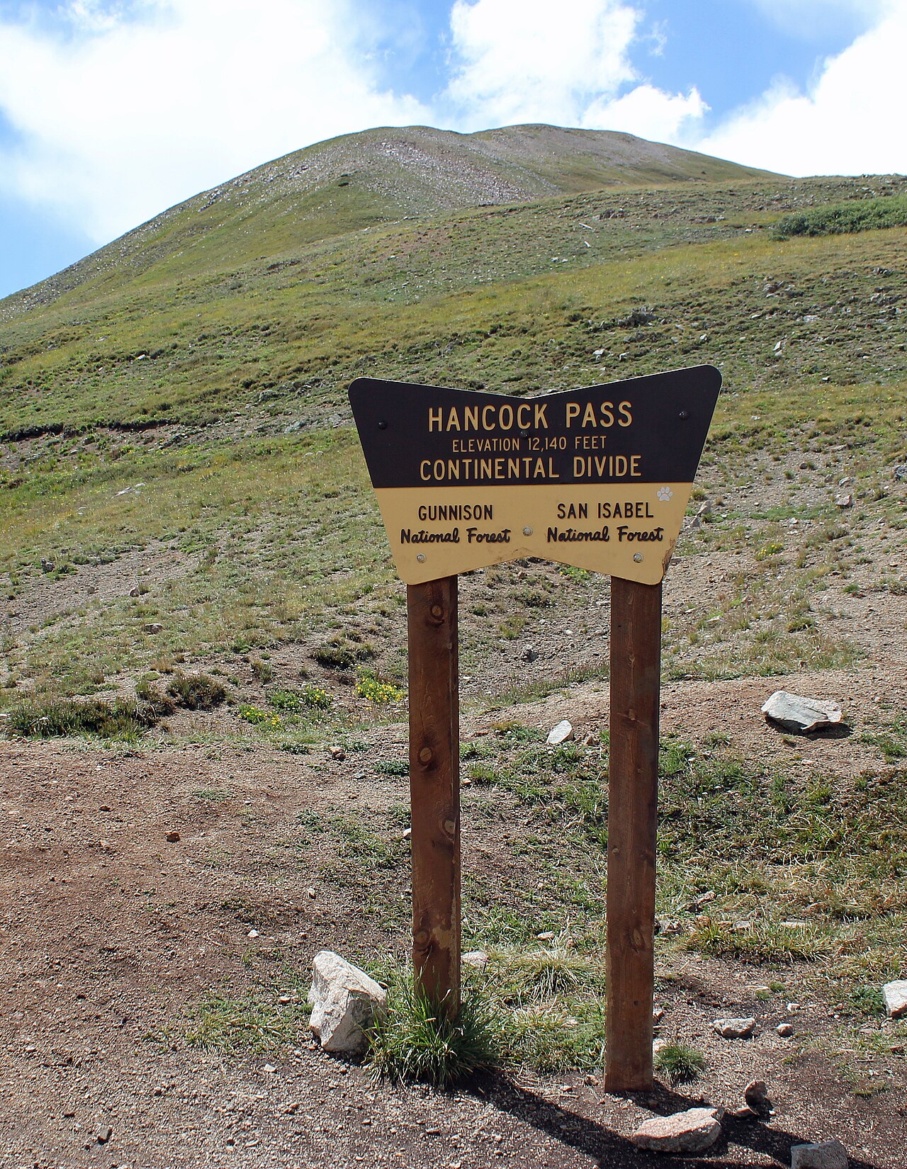
Brown Forest Service sign reading Hancock Pass, Elevation 12,140 feet, Continental Divide, Gunnison and San Isabel National Forests, on a grassy alpine slope
The sign at Hancock Pass, where the freight wagons crossed the divide in 1881.Photo: Jeffrey Beall, 2014, CC BY 3.0, via Wikimedia Commons
On the pass elevation: The sign on Hancock Pass reads 12,140 feet. The U.S. Geological Survey’s place-name database gives 12,208 feet.

Timeline

Oct 1879
The South Park and Rio Grande railroads sign a joint operating agreement; the South Park line will build west through Chalk Creek.
Jan 1880
Work begins on the Alpine Tunnel under Altman (Alpine) Pass.
1880
The Hancock Town Company plats lots on the Hancock Placer. Post office opens September 10.
Late 1880
The railroad reaches St. Elmo.
1881
Rails reach Hancock, the railhead for the push west. About 200 people live there.
July 26, 1881
The tunnel’s two headings meet.
July 1882
The first train runs through the Alpine Tunnel. The line reaches Gunnison in September.
Mar 1884
An avalanche destroys Woodstock, west of the tunnel, killing 13.
1887
Hancock’s depot is moved to Romley; the post office closes June 24.
1888
A cave-in closes the tunnel for seven years.
1895
The tunnel reopens; four men die of carbon monoxide during the work.
1898–1899
The line becomes part of the Colorado & Southern.
1903–1904
Hancock’s post office briefly reopens.
Nov 1910
After another cave-in, the last locomotive passes through; the route over the divide is abandoned.
1923–1926
Rails between the tunnel and Hancock are pulled up; the Chalk Creek branch is gone by 1926.
1996
The Alpine Tunnel Historic District, including parts of Hancock, is listed on the National Register.
Visit guide — Hancock, Colorado
Can you visit?Yes. The townsite is national forest land, open to the public in summer and fall.
Getting thereFrom US 285 at Nathrop, take County Road 162 west about 15 to 16 miles past Mount Princeton Hot Springs. Just before St. Elmo, turn left onto Forest Road 295 and follow it about 5.5 miles up the old railroad grade to Hancock.
Coordinates38.6403, -106.3659
Road conditionsFR 295 is a graded dirt road with potholes and rocks; a careful driver can make it in a car, but higher clearance is better. Hancock Pass beyond is a difficult road for short-wheelbase 4WD only.
SeasonUsually snow-free July through September, sometimes into October. Snow often lingers through June.
What to seeCellar holes, foundations and saloon logs at the townsite; the Allie Belle ore chute and Mary Murphy tram ruins along FR 295; the Alpine Tunnel east portal, 2.8 miles on foot.
HikingAlpine Tunnel Trail #1438 follows the grade 2.8 miles to the east portal; no motor vehicles. Hancock Lake Trail #1422 climbs to two alpine lakes.
ServicesNone. St. Elmo’s store is open in summer; fuel and lodging are in Buena Vista and Nathrop.
Land statusPike-San Isabel National Forest, Salida Ranger District. Some mining ground along FR 295 near Romley and the Mary Murphy is private.
Fees and campingNo fee known. Dispersed camping is allowed along FR 295, but not on the shore of Hancock Lake.
High-country hazards: Hancock sits at about 11,000 feet, and storms build fast on summer afternoons, with lightning above treeline. There is no cell service. The slopes around the townsite are full of old adits, shafts and loose waste rock; never enter a mine or climb on old structures.
Respect the ground: Do not dig, metal detect or collect anything, including bottles, cans and spikes. The railroad grade, its ties and the townsite are protected historic features. Stay off posted private claims, and leave the saloon logs and foundations as you found them.
Approximate location of Hancock at the end of Forest Road 295, about 5.5 miles above St. Elmo.

Historic sites nearby

St. Elmo, CO
~5.5 miles by road, also on this site
The best-preserved town on Chalk Creek · summer store
Romley, CO
~2.5 miles down FR 295
Mary Murphy rail stop · town gone, private land
Alpine Tunnel East Portal
2.8 miles on foot
Caved-in portal · Trail #1438 on the old grade
Alpine Station & the Palisades
~2 miles straight line, reached from Pitkin
Restored telegraph office · dry-laid stone wall
Woodstock, CO
~2.5 miles west in a straight line, reached from Pitkin, also on this site
Section camp below the Palisades · 1884 avalanche
Pitkin, CO
~11 miles over Hancock Pass, 4WD
Supply town on the west side · still lived in
Tin Cup, CO
~10 miles straight line, much farther by road, also on this site
Lively silver camp of 1880 · Boot Hill cemetery
Winfield, CO
~24 miles straight line, much farther by road, also on this site
1880s silver camp at the head of Clear Creek · schoolhouse museum

Further reading

Books and records about Hancock and the Alpine Tunnel
Historic Alpine Tunnel
Dow Helmers · Sage Books, Denver, 1963 — the standard history of the tunnel’s building and collapse
Denver, South Park & Pacific
M. C. Poor · Rocky Mountain Railroad Club, Denver, 1949
Stampede to Timberline: The Ghost Towns and Mining Camps of Colorado
Muriel Sibell Wolle · Boulder, 1949
History, Geology, and Environmental Setting of Selected Mines in the Chalk Creek Mining District, Chaffee County, Colorado
J. T. Neubert and R. H. Wood II · Colorado Geological Survey Open-File Report 01-13, 2001
Hancock ColoradoColoradoColorado Ghost TownsGhost TownChaffee CountyAlpine TunnelDenver South Park & PacificNarrow Gauge RailroadRailroadHancock PassContinental DivideSt. Elmo

Sources

U.S. Forest Service — Alpine Tunnel Trail #1438, Hancock Lakes and Alpine Tunnel Historic District

Wikipedia — Alpine Tunnel, Denver, South Park and Pacific Railroad, Mary Murphy Mine and Hancock Pass

Colorado Geological Survey — Chalk Creek Mining District report

National Park Service — Alpine Tunnel Historic District, National Register record

Uncover Colorado — Hancock; 4x4explore — Hancock and Alpine Tunnel

Colorado Public Radio — Historic Alpine Tunnel road reopens (2024); Denver7 — the Woodstock avalanche

Photos: Historic American Buildings Survey, public domain; Tim Dennehey, CC BY-SA 3.0; A.L. Szalanski, CC BY-SA 3.0 and CC BY-SA 3.0; John Holm, CC BY 2.0; Jeffrey Beall, CC BY 3.0
Similar Posts

Leave a Reply

Your email address will not be published. Required fields are marked *