St. Thomas, Nevada
Most ghost towns die once. St. Thomas has died, drowned, and surfaced again more times than almost any town in the West. It began as a Mormon farming settlement at the meeting of the Muddy and Virgin rivers, was abandoned once over a tax dispute, rebuilt into a prosperous little agricultural town — and was then deliberately evacuated and flooded beneath Lake Mead when Hoover Dam closed its gates. For decades it lay under more than sixty feet of water. But Lake Mead rises and falls, and every time it falls far enough, St. Thomas comes back.
This is the documented history of St. Thomas, the real story of its last resident Hugh Lord, and how to walk its exposed foundations today inside Lake Mead National Recreation Area. Where the record and the folklore diverge — and for this town they often do — we say so.
The Muddy Mission: a Mormon town in the desert, 1865
Long before St. Thomas, the lower Muddy and Virgin country belonged to Ancestral Puebloan and Basket Maker peoples; the archaeological complex nearby was later called the “Lost City,” or Pueblo Grande de Nevada, much of it salvaged before Lake Mead rose and recreated at the Lost City Museum in Overton. Into this valley, in the mid-1860s, Brigham Young directed Mormon missionaries to plant a chain of settlements — the Muddy Mission — to grow cotton and other warm-climate crops and to push commerce and travel toward the Colorado River.
The federal National Register documentation records a first party led by Thomas Smith reaching the confluence on January 1, 1865, and naming the settlement St. Thomas in his honor. Irrigation from the Muddy River made the desert workable: cotton, wheat, corn, melons, grapes, peaches, and pumpkins, with livestock besides. The wider mission eventually took in St. Joseph, Overton, and other small communities. One early distinction: St. Thomas even served briefly as the seat of Pah-Ute County.
St. Thomas also holds a place in one of the defining exploration stories of the West. John Wesley Powell’s celebrated 1869 expedition down the Green and Colorado rivers ended here, at St. Thomas, after his party emerged from the Grand Canyon — making this small farming outpost the finish line of a national epic.
How St. Thomas accidentally became Nevada — and emptied out, 1871
The settlers’ jurisdictional problem is often flattened into “they accidentally built in Nevada.” The reality was messier. Arizona Territory had organized Pah-Ute County in this region in 1865; Congress then enlarged Nevada’s boundaries, and the territory reaching the Colorado River was attached to Nevada. When the lines were finally surveyed, the Muddy Mission settlers learned their farms lay in Nevada, not where they had believed. Nevada promptly demanded several years of back taxes — payable in gold coin.
Unwilling or unable to pay, and with Brigham Young leaving the decision to them, in 1871 all but one family departed. Most moved to Utah’s Long Valley, founding or joining towns like Glendale, Orderville, and Mount Carmel. Daniel Bonelli stayed on and claimed abandoned property. New Mormon settlers began returning roughly a decade later, in the 1880s.
Resettlement and the high point, 1880s–1920s
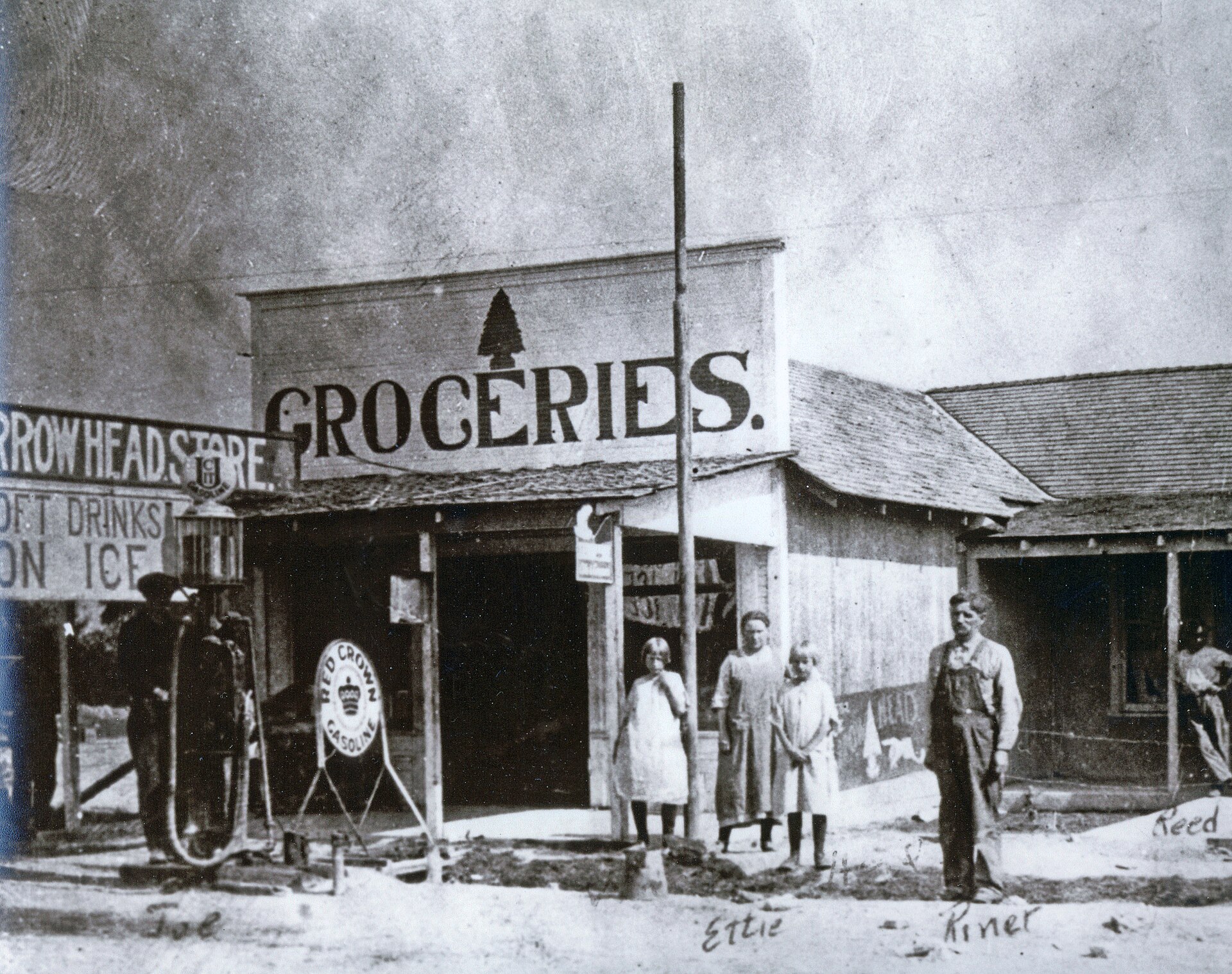
By the late nineteenth and early twentieth centuries, St. Thomas had grown from a mission outpost into a stable agricultural town of about 500 people. It had a school, a post office, grocery stores, a church, a soda fountain, and several automobile garages — though, NPS notes, it never had indoor plumbing or electric service.
Farming stayed central. The National Register history describes locally important grapes, cantaloupes, and vegetable crops; beginning around 1920, Norman Shurtliff marketed his “Dollar Box” of assorted vegetables, with produce shipped to markets in Utah, California, and Las Vegas. Transportation sharpened the town’s importance: St. Thomas became the end of a railroad spur connected with the San Pedro, Los Angeles & Salt Lake Railroad, and a stop on the Arrowhead Trail, the early automobile route between Southern California and Salt Lake City. NPS specifically credits the Arrowhead Trail as a reason the community prospered.
Hoover Dam and the drowning of St. Thomas, 1928–1938
What ultimately doomed St. Thomas was not a mining bust or a railroad bypass but a deliberate federal water project. In 1928 President Calvin Coolidge signed legislation authorizing what was then called Boulder Dam — later Hoover Dam. The reservoir behind it would inundate the lower Muddy and Virgin valleys, St. Thomas included. Residents in the flood zone were told they would have to relocate, and the government acquired or condemned affected property and compensated owners.
The dismantling was gradual, not a single dramatic flight. Buildings that could be reused were moved or taken apart; others were demolished. Civilian Conservation Corps crews cut down the cottonwoods and orchards that would become navigation hazards once submerged. One of the least-known but best-documented episodes was moving the dead before moving the lake: the government hired Boulder City mortician Howell Garrison to remove graves, and the National Register records 87 graves handled in the larger relocation effort, the last removals completed on March 4, 1935. The resulting St. Thomas Memorial Cemetery, south of Overton, survives today as the most intact property directly tied to the vanished town.
Lake Mead began filling in 1935. The rise was slow enough that parts of the valley kept being farmed as the shoreline crept closer — but by the late 1930s the outcome was obvious. The National Register preserves an extraordinary detail from the final day: on June 11, 1938, postmaster Leland Whitmore reportedly canceled about 4,000 stamps as the water reached the post-office foundation, then at around four in the afternoon threw the postal canceler into the rising lake while workers demolished the building. That same date is the one NPS uses for the departure of Hugh Lord, remembered as the town’s last citizen, who rowed away from his house as the reservoir overtook the community. At full pool, St. Thomas would lie beneath more than sixty feet of water.
Hugh Lord, and the town that keeps coming back
For a town that vanished less than a century ago, St. Thomas has gathered a remarkably rich body of folklore. The secure historical core is simple: Hugh Lord was among the last holdouts, and NPS identifies him as the last citizen to leave, rowing away on June 11, 1938. A UNLV Special Collections photograph from June 1938 adds a tantalizing piece of evidence — a shack burning amid the flooding, cataloged as “probably Hugh Lord’s.”
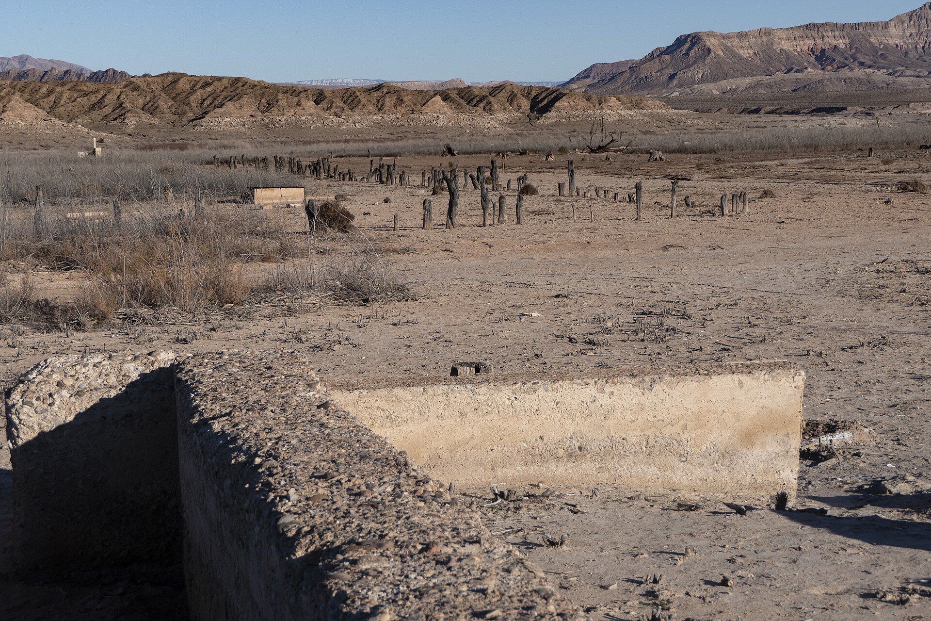
St. Thomas did not stay hidden. Lake Mead’s elevation has always fluctuated, and low-water periods have exposed the town again and again. The National Register nomination records exposure during low water in 1945, 1952, 1964, 1991, and 2004; former residents and their descendants have gathered for reunions in 1945, 1963, and 2012. The long modern decline of Lake Mead eventually turned St. Thomas back into a dry-land destination rather than a fleeting glimpse. As of the Bureau of Reclamation’s October 2026 hydrologic update, Lake Mead stood around 1,038 feet above sea level — far below its historic high regime, and consistent with the continuing exposure of the townsite that NPS now interprets for visitors.
What actually survives
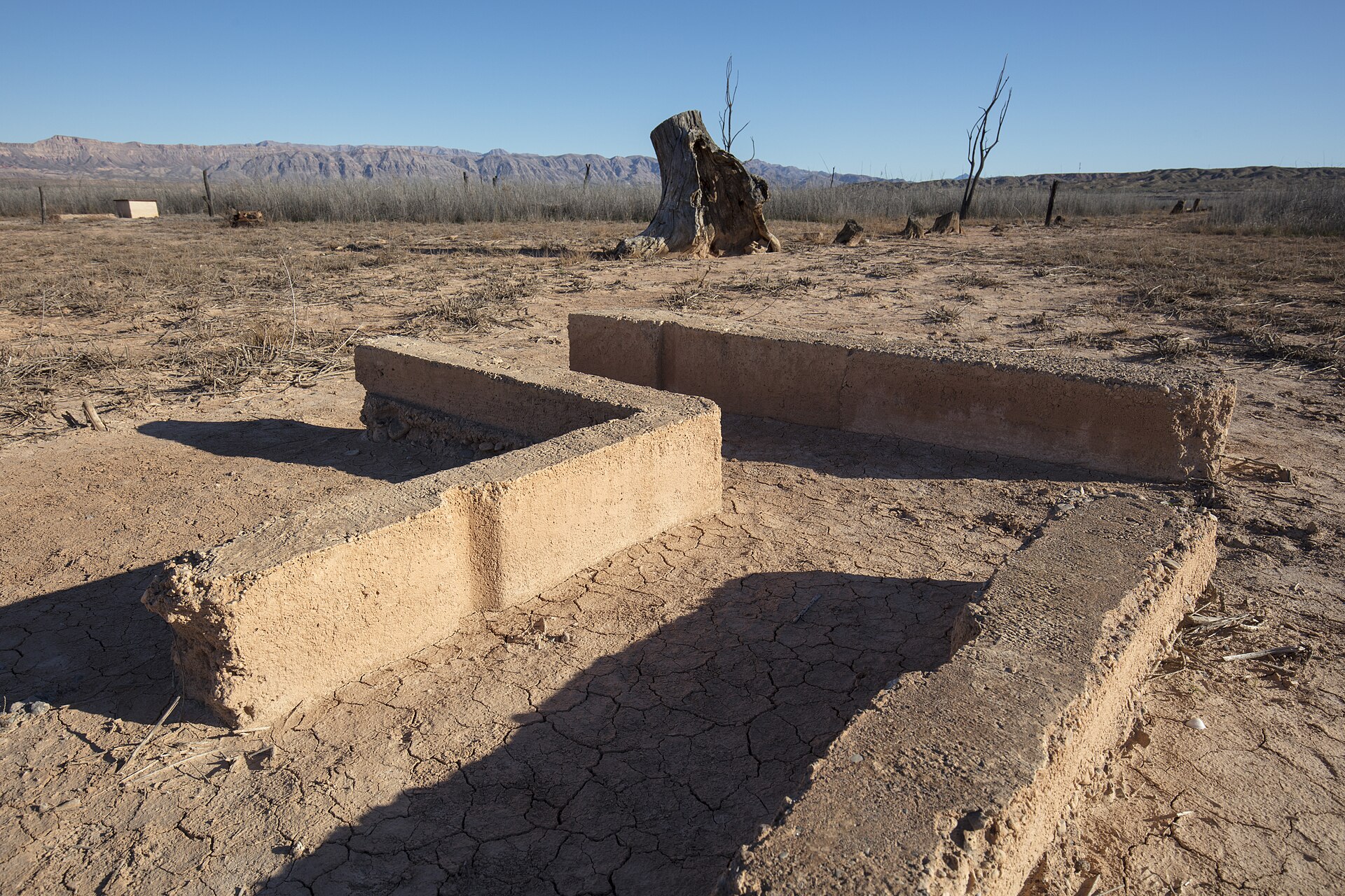
Don’t expect intact Victorian storefronts. Decades underwater, demolition before inundation, and repeated weathering have left an archaeological townscape, not a preserved streetscape. The National Register record specifically identifies building foundations, walkways, cisterns, and old tree stumps; NPS describes remains ranging from small glass fragments to substantial foundations, with roads and former town alignments still traceable across the site. Everything at the exposed townsite is a protected archaeological resource.
Timeline
Visiting St. Thomas now
St. Thomas is an officially interpreted NPS hiking destination in Lake Mead National Recreation Area — not a developed attraction with museum hours, but an exposed desert archaeological site at the end of a dirt road. Plan for heat, carry everything you’ll need, and leave the ruins exactly as you find them.
Nearby ghost towns & historic sites
Also within the broad 50-mile radius: Bonelli’s Landing (ferry landscape, now a submerged-resource area) and the Old Las Vegas Mormon Fort (1855), a useful comparison with the earlier Mormon colonization at Las Vegas Springs. For more Nevada ghost towns on the archive, see Tonopah, Belmont, and Rhyolite.
Further reading
Sources:
National Park Service, “St. Thomas, Nevada,” Lake Mead National Recreation Area — nps.gov/lake.
National Park Service, “St. Thomas Ruins” and “Underwater Resources,” Lake Mead NRA — stthomas · underwater resources.
National Park Service, “Hike the St. Thomas Trail” — nps.gov; and “Fees & Passes, Lake Mead NRA” — fees.
St. Thomas Memorial Cemetery, National Register of Historic Places nomination — NPGallery, npgallery.nps.gov.
U.S. Bureau of Reclamation, Lake Mead end-of-month and weekly elevation records (Oct. 2026 hydrologic update) — usbr.gov.
UNLV University Libraries, Special Collections — period photographs of St. Thomas (June 1938 flooding; shack cataloged “probably Hugh Lord’s”). Wikipedia, “St. Thomas, Nevada.” Travel Nevada, “St. Thomas Ghost Town.”
Photo credits: Hero (exposed townsite foundations) and inline ruins (cistern & foundation): Andrew Cattoir / National Park Service, Lake Mead National Recreation Area — public domain, via Wikimedia Commons. Historic Arrowhead Store: Lake Mead NRA Public Affairs — CC BY-SA 2.0, via Wikimedia Commons.