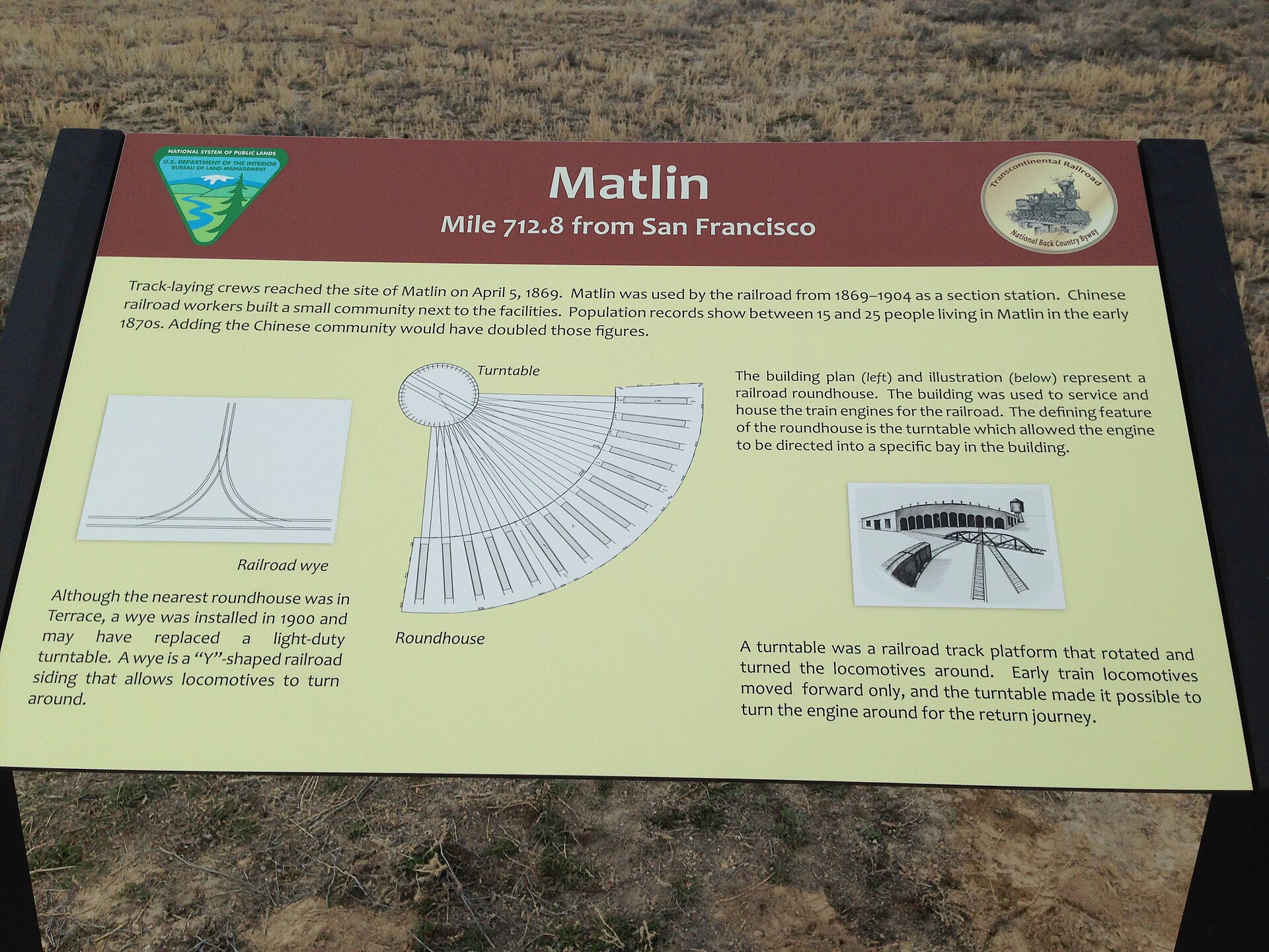
Bureau of Land Management interpretive sign titled Matlin, Mile 712.8 from San Francisco, standing in sagebrush beside the old railroad grade

Matlin, Utah

Quick facts
What it isCentral Pacific section station and siding
FoundedTrack reached the site April 5, 1869
Milepost712.8 miles from San Francisco
RailroadsCentral Pacific, then Southern Pacific
Population15 (1870) and 25 (1876)
Section station closedAbout 1904; rails removed 1942
Elevation4,603 feet
Coordinates41.5594, -113.3589
State and countyUtah, Box Elder County
TodayBLM historic site on the Transcontinental Railroad Backcountry Byway
⚠ No services · No water · High clearance recommended · Impassable when wet · Protected site, no collecting
Bureau of Land Management interpretive sign titled Matlin, Mile 712.8 from San Francisco, standing in sagebrush beside the old railroad grade
The BLM interpretive sign at Matlin on the Transcontinental Railroad Backcountry Byway, 2016. Photo: Bureau of Land Management Utah (provided by Ray Kelsey), via Wikimedia Commons. Public domain.

Matlin was a small railroad station in the empty desert north of the Great Salt Lake. Central Pacific track crews reached the spot on April 5, 1869, five weeks before the rails met at Promontory Summit, and the railroad kept a section crew here to look after the track until about 1904. Most of those workers were Chinese, and they lived beside the station in their own bunkhouse and dugouts. When Southern Pacific opened the Lucin Cutoff across the lake in 1904, the old line through Matlin became a quiet branch, and in 1942 its rails were torn up for the war effort. Today Matlin is a stop on a BLM backcountry byway, with an earthen wye, the old grade, scattered traces of the camp and an interpretive sign.

A section station on the desert grade

Matlin sits on the 1869 Central Pacific grade in western Box Elder County, 712.8 miles from San Francisco by the railroad’s count. Below the Matlin Mountains, the line crossed open sagebrush flats with no towns for miles. To keep the track safe, the Central Pacific set up section stations along the line, each with a foreman and a gang of track workers. Matlin was one of them.

According to the Bureau of Land Management’s study of the Utah stations, Matlin served the railroad from 1869 to about 1904. A railroad station plan from about the 1880s shows a windowless “China Bunk House” about 16 by 24 feet. In 1900 the railroad built a wye, a triangle of track used to turn engines around, which may have replaced a light-duty turntable. The BLM marker notes that the nearest roundhouse was at Terrace, about nine miles west.

According to an archaeologist who works with the State of Utah, Matlin also served as a helper station, a place where extra locomotives were kept to help heavy trains over the grades nearby.
On the helper station and buildings: The BLM study of the Utah stations cites Taro Yagi, who recalled in the Golden Spike Oral History (1969) that freight trains often needed four helper engines to climb Red Dome Hill, the grade that rises east of Matlin toward Ombey. It does not say where those engines were kept. Other written sources name Kelton as the branch’s helper station, so Matlin’s role as a helper base rests on the archaeologist’s account. Some accounts also list a water tank and a freight platform at Matlin; the BLM study describes those for section stations in general but does not document them here.
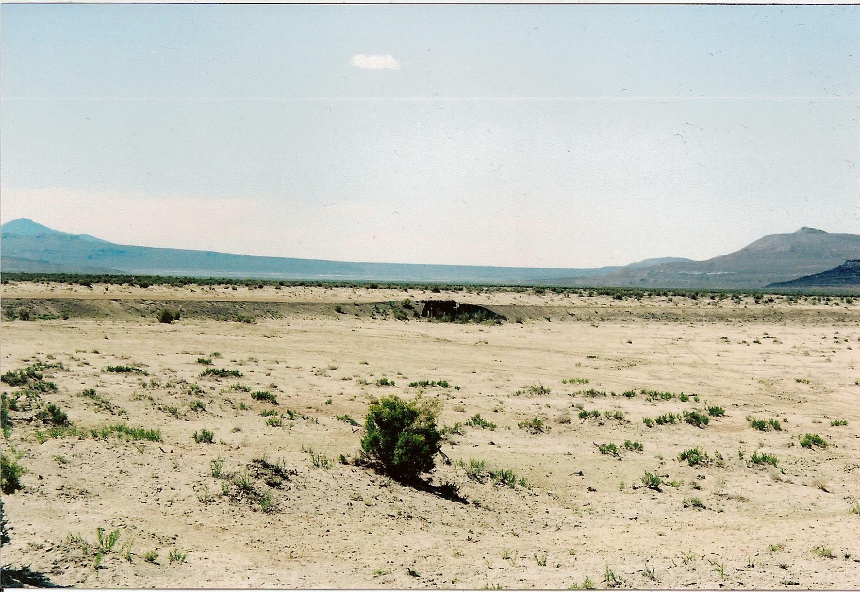
Low raised railroad grade crossing a flat sagebrush desert toward distant mountains west of Kelton, Utah
The 1869 Central Pacific grade west of Kelton, on the stretch that leads toward Matlin.Photo: Tricia Simpson, 2007, via Wikimedia Commons, CC BY-SA 4.0.

The people of Matlin

Published population figures list 15 people at Matlin in 1870 and 25 in 1876. The BLM sign at the site says Chinese railroad workers built a small community next to the station, and that counting them would have doubled those figures.

On the population: Sources disagree on whether the Chinese workers were counted. A study of the 1870 census by Michael Polk, Christopher Merritt and Kenneth Cannon lists 13 Chinese workers and 2 foremen at Matlin, which adds up to the same 15, so the 1870 figure may already include them.

Chinese laborers did most of the track maintenance on this part of the Central Pacific for about two decades after 1869. At most section stations their bunkhouse stood apart from the foreman’s house. At Matlin, archaeologists recorded the bunkhouse site in 2018, a low mound of decayed peeled posts that once held the building off the ground. Pieces of Chinese porcelain, including “Bamboo” and “Double Happiness” pattern bowls, along with an opium tin, a clay pipe and teapot fragments, have been found here. The base of one porcelain rice bowl from the station has a mark cut into it to identify its owner, probably one of the Chinese workers. The BLM’s 1981 survey also noted dugouts with 19th-century Chinese artifacts that had been damaged by illegal digging.

Not confirmed at Matlin: Some accounts place Chinese worker graves and funeral offering bowls near Matlin. The studies checked for this post, including published summaries of recent burial surveys in Utah, do not name Matlin.

A bicyclist stops for the night

In the spring of 1884, Thomas Stevens rode through on the first bicycle trip around the world, following the railroad across the Utah desert. In Around the World on a Bicycle (1887), he wrote that he found a bed at the Matlin section house with a “whole-souled section-house foreman.” It is one of the few first-hand descriptions of daily life at the station.

The Lucin Cutoff and a long fade

The 1869 line looped north around the Great Salt Lake and climbed over the Promontory Mountains. In 1902 Southern Pacific began a straight route across the lake, the Lucin Cutoff. Through freight trains switched to the Cutoff on March 8, 1904, and the BLM study says its completion ended Matlin’s life as a section station.

The rails stayed, though. The old line became the Promontory Branch, and Matlin remained a siding in employee timetables; a 1931 timetable still shows a siding for 33 cars and the wye. On March 31, 1937, the Utah Public Service Commission let Southern Pacific stop running trains between Kelton and Watercress, the stretch that includes Matlin.
On the end date: Many accounts say Matlin was abandoned in 1904. That is true of the section crew, but the siding stayed on the books until the branch was abandoned in 1942.
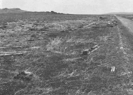
Black and white photo of flat desert ground at Matlin with old wooden railroad ties lying in rows beside the abandoned railroad grade
Looking east at the Matlin siding, with the wye in the foreground and old ties left beside the grade after the rails were pulled.Photo: Bureau of Land Management, from Raymond and Fike, Rails East to Promontory (1981), via Wikimedia Commons. Public domain.

The rails go to war

On June 11, 1942, the Interstate Commerce Commission approved abandoning the branch between Lucin and Corinne. The steel was wanted for military depots during World War II. Salvage crews began pulling rail near Corinne on July 1, 1942, and worked west, finishing in early September. On September 8, 1942, Governor Herbert B. Maw joined an “undriving” ceremony at Promontory as a spike was pulled from the old line. The crews left the wooden ties lying along the shoulders of the grade, which later became a road.

The 2020 Matlin Fire

For almost 80 years the dry desert preserved those ties. That changed in June 2020, when a lightning storm started several fires in western Box Elder County. The Matlin Fire was reported on the evening of June 3 and was contained the next evening. News reports put it at about 8,000 acres; the federal fire report listed 6,292 acres.

The fire destroyed two timber trestles from the 1870s and burned the 1940s ties along the grade into lines of ash and shallow marks in the soil. A wooden box culvert from about 1880 to 1900 caught fire. Firefighters put it out, but it flared up again the next morning and had to be doused a second time, and the state hoped to save it by sliding a metal pipe inside. When state historic preservation officer Chris Merritt toured the burn in the days after the fire with BLM archaeologist Mike Sheehan and archaeologist Ken Cannon, he told KSL it was “like driving into Mordor.” The earthen wye at Matlin came through undamaged.

On the fire’s size: Early news coverage gave about 8,000 acres. The National Interagency Fire Center’s report of June 6, 2020 listed 6,292 acres. Some summaries also give June 4 as the start date; the fire was first reported the evening before.

What remains

No buildings stand at Matlin. Visitors can see the raised 1869 grade, the earthen outline of the 1900 wye, cuts and fills along the line, the low remains of the Chinese bunkhouse, scattered cans, glass and porcelain, and the BLM interpretive sign. The ties shown in older photos are gone, burned in 2020.

Where the name Matlin came from is not recorded in the railroad and BLM sources checked for this post. The Matlin Mountains rise to the north.

Timeline

Apr 5, 1869
Central Pacific track crews reach Matlin, 712.8 miles from San Francisco.
May 10, 1869
The rails meet at Promontory Summit.
1870
Population listed as 15; the census counts 13 Chinese workers and 2 foremen.
1876
Population listed as 25.
1884
Bicyclist Thomas Stevens spends a night at the Matlin section house.
1900
A wye is built at Matlin, possibly replacing a light-duty turntable.
1904
The Lucin Cutoff opens and Matlin’s section station closes.
1931
Timetables still list a 33-car siding and wye at Matlin.
Mar 31, 1937
Trains stop running between Kelton and Watercress.
Jun 11, 1942
The ICC approves abandoning the line from Lucin to Corinne.
Jul–Sep 1942
The rails are pulled up for the war effort; ceremony at Promontory on September 8.
1987
The Central Pacific Railroad Grade Historic District is listed on the National Register of Historic Places.
2018
Archaeologists record the Chinese bunkhouse site.
Jun 3–4, 2020
The Matlin Fire burns the old ties and two nearby 1870s trestles.
Visiting Matlin
Can you visitYes. Matlin is on BLM land along the Transcontinental Railroad Backcountry Byway. There is no fee.
Getting thereFrom the east, drive to Golden Spike National Historical Park on SR-83 and follow the byway west along the old grade past Kelton. From the west, start at the byway’s Lucin entrance. The BLM byway map also shows dirt roads linking the grade north to SR-30 near Park Valley. The sign stands on the right when you travel west.
Coordinates41.5594, -113.3589 (townsite); the BLM sign is about 0.1 mile west-southwest.
Road conditionsNarrow gravel and dirt. The BLM says ordinary cars can usually reach Kelton when dry; west of Kelton, where Matlin is, expect washouts, ruts and potholes, and use a high-clearance vehicle. Wet clay turns impassable.
What to seeThe BLM sign, the 1900 wye earthwork, the raised grade, and nearby sign posts at Red Dome, Romola and Ombey.
ServicesNone on the byway: no water, fuel, food or shade, and little or no phone signal.
Land statusBLM land within the Central Pacific Railroad Grade Historic District, managed as an Area of Critical Environmental Concern.
Remote desert: Carry plenty of water, extra fuel and at least one good spare tire; old spikes and sharp ballast cause flats on the grade. Stay off the road after rain or snowmelt. Summer heat is severe and there is no shade. Tell someone your route before you go.
Respect the ground: Matlin is a protected archaeological site. Do not dig, metal detect, or take artifacts, cans, glass or porcelain; collecting on federal land is illegal under the Archaeological Resources Protection Act. Keep vehicles on the established road and stay off detoured trestles and culverts.
Approximate location of Matlin on the 1869 Central Pacific grade.

Historic sites nearby

Red Dome, UT
~4 rail miles west
Siding named for Red Dome Mountain, used 1895–1907
Romola, UT
~5 rail miles east
1899 siding built for ranchers shipping livestock
Terrace, UT
~9 miles west-southwest, also on this site
Central Pacific division town with a roundhouse and cemetery
Ombey, UT
~10 rail miles east
Section station near the summit of Red Dome Pass
Kelton, UT
~18 miles northeast
Railroad and freighting town with a cemetery
Lucin, UT
~31 miles west-southwest, also on this site
Railroad town that moved twice, ending on the Lucin Cutoff
Golden Spike NHP, UT
~42 miles east
Where the rails met on May 10, 1869

Distances are approximate straight-line miles from Matlin, or rail miles along the old grade where noted. Driving distances are much longer.

Further reading

Books and studies
Rails East to Promontory: The Utah Stations
Anan S. Raymond and Richard E. Fike · Bureau of Land Management, Utah Cultural Resource Series No. 8, 1981
Rails East to Ogden: Utah’s Transcontinental Railroad Story
Michael R. Polk and others · Bureau of Land Management, Utah Cultural Resource Series No. 29, 2021
Chinese Workers at Central Pacific Railroad Section Station Camps, 1870–1900
Michael R. Polk, Christopher W. Merritt and Kenneth P. Cannon · Chinese Railroad Workers in North America Project, Stanford University
Around the World on a Bicycle, Volume 1
Thomas Stevens · Sampson Low, London, 1887
Matlin UtahUtahUtah ghost townsghost townBox Elder CountyCentral PacificSouthern Pacifictranscontinental railroadChinese railroad workersrailroadBLM

Sources

Bureau of Land Management — Rails East to Promontory: Matlin and nearby stations; Transcontinental Railroad Back Country Byway; Byway map

Historical Marker Database — Matlin (BLM marker); Wikipedia — Matlin, Utah

Utah Rails — Promontory Branch stations; Southern Pacific in Utah; ICC dockets

National Park Service — Golden Spike cultural landscape report; Central Pacific Railroad Grade Historic District (NRHP)

Polk, Merritt and Cannon — Chinese Workers at Central Pacific Railroad Section Station Camps; Internet Archive — Rails East to Ogden; Merritt, Polk, Cannon and others, “Rolling to the 150th,” Utah Historical Quarterly 85, no. 4 (2017)

KSL — Utah wildfire destroyed nearly 150-year-old pieces of railroad history; Officials gain containment on lightning-caused fires; Railfan & Railroad — Utah wildfire destroys trestles along first transcontinental route; National Interagency Fire Center — Situation report, June 6, 2020

Thomas Stevens — biography

Photos: Bureau of Land Management Utah, photo provided by Ray Kelsey, via Wikimedia Commons (public domain); Bureau of Land Management, Rails East to Promontory, via Wikimedia Commons (public domain); Tricia Simpson, via Wikimedia Commons, CC BY-SA 4.0.
Similar Posts

Leave a Reply

Your email address will not be published. Required fields are marked *