Bayhorse, Idaho
Idaho
Gold & Silver Mining
Silver in the Salmon River Mountains · 1877–1920s
15 min read
Founded
Silver rush 1877; town built out from 1880 around its own smelter
Peak Population
About 400 (NRHP); park histories give a 300–500 range
County / Region
Custer County · a narrow canyon in the Salmon River Mountains, over 6,000 ft
What It Mined
Lead-silver (argentian tetrahedrite) — chiefly the Ramshorn mine
Still Standing
The 1882 mill, nine charcoal kilns, the “Wells Fargo” stone building, hotel, store, cemeteries
Status
Preserved in “arrested decay” as the Bayhorse Unit of Land of the Yankee Fork State Park
$7 per vehicle (Idaho State Parks)
Open seasonally (from May 1)
Walk the townsite on foot
Stay out of mines & buildings
Contaminated soils off-path

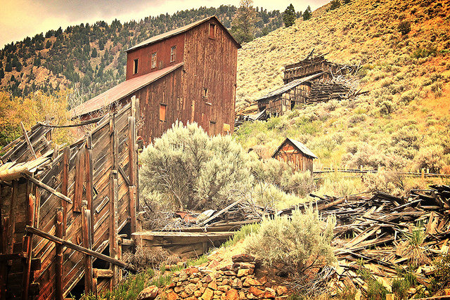
The 1882 Gilmer & Salisbury mill still dominates the Bayhorse hillside — the camp’s signature silhouette. Photo: Sassygirljenna, Wikimedia Commons, CC BY-SA 4.0.
Most Western ghost towns are a single boom and a single bust. Bayhorse is stranger and more complete than that. It was a remote lead-silver camp wedged into the bottom of a narrow Salmon River canyon in central Idaho, and because it sat so far from any railroad, it had to become a self-contained industrial machine to survive at all: it built its own smelter, a battery of nine stone charcoal kilns to fuel it, a water-powered sawmill, a wire-rope tramway down the mountainside, and a tall concentration mill — all crammed onto whatever flat ground could be found beside the creek. It boomed in the 1880s around the deep, rich Ramshorn mine, collapsed almost overnight in 1889, and then refused to die, reviving again and again into the 1920s and drawing prospectors as late as the 1980s.
Because mining kept circling back to this canyon for a century, an unusual amount survived — the mill, the kilns, a stout stone “Wells Fargo” building, the hotel, a store, two cemeteries, mine and tram remains — and it’s all now protected as the Bayhorse Unit of Land of the Yankee Fork State Park. This is the documented history of that camp, the colorful stories worth separating from the record, and how to visit what remains.
In November 1889 Bayhorse went, in the National Register’s words, “practically deserted” within about two weeks — more than 300 men thrown out of work almost at once.
— from the Bayhorse Historic District National Register nomination, on the camp’s first great collapse
Not actually a Yankee Fork gold camp
Bayhorse is preserved and interpreted today alongside Custer, Bonanza, and the Yankee Fork Gold Dredge, so it’s easy to assume it was part of the same gold rush. It wasn’t. Bayhorse and nearby Clayton formed their own lead-silver mining district, geologically and economically distinct from the lode-gold and placer-gold country of the Yankee Fork a couple dozen miles west. Idaho State Parks groups them because it preserves all of them within one historic-park system — not because they shared an ore body. Keeping that straight is the key to understanding everything about Bayhorse: its wealth was in silver-bearing tetrahedrite and galena, and its whole industrial apparatus was built to smelt that heavy, refractory rock on the spot.
Where the name comes from. The Idaho State Historical Society traces “Bay Horse” to 1864, when a prospector passing through the Salmon River Mountains — said to be traveling with two bay-colored horses — examined mineralized ground along the creek, which then took the name Bay Horse Creek. The Society records this in its official reference series, so it’s far better grounded than a modern roadside legend; but no contemporaneous 1864 diary or claim actually documents the man or his horses. It’s the accepted traditional explanation of the name, not an independently verified episode.
From prospect to silver town
Prospectors first noticed mineralization along Bayhorse Creek in the 1860s, but territorial miners were chasing placer gold and largely ignored these base-metal lodes. W. A. Norton located the first formal claims in 1872, and he and S. A. Boone recorded a lode in 1873. The decisive moment came in the spring of 1877, when a party out of Bonanza crossed the divide and located what became the great Ramshorn mine high on a ridge above the canyon. A rush followed, and Bayhorse and Clayton miners formally organized their district on October 1, 1877.
The problem was immediately obvious: the ore was fabulously rich, and the canyon was impossibly remote. In 1878 about 30 tons of the best Ramshorn ore shipped to Salt Lake City returned roughly $800 a ton; in 1879 another 75 tons ran about $900 a ton — but the freight alone cost an extraordinary $47 per ton, because every pound had to be packed by mule down the creek and then wagon-hauled all the way to the railhead at Blackfoot. Those numbers explain the entire shape of the town that followed: at $47 a ton to move rock, a local smelter and mill weren’t luxuries, they were the only way to make lower-grade ore pay at all.
The ram that “revealed” the Ramshorn. A favorite local story says a hunter around 1880 shot a big bighorn ram, which tumbled down a talus slope and gouged open a glittering vein of silver ore — the discovery of the Ramshorn mine. It’s a great tale, but it can’t be literal discovery history: the Ramshorn was located and recorded in the spring of 1877, several years before the supposed hunt. The documented version is more prosaic — experienced prospectors traced mineral “float” up the steep shale spurs to the outcrop. Enjoy the ram story as folklore, not as the record.
The smelter that built a town
In 1880 the Omaha Smelting and Refining Company — which had picked up the Beardsley and Skylark properties — built a roughly 25-to-30-ton smelter at Bayhorse, said to be the first in the Salmon River mining districts. It cost about $35,000 and combined a water-jacket furnace, a five-stamp battery, a Blake crusher, and a water-powered turbine driven by Bayhorse Creek. The effect was transformative: ore that had been shipped as far as Omaha, Denver, and Salt Lake for treatment could now be smelted on site, and the plant reportedly turned out about $100,000 in bullion in its first thirty-day run. That summer, machinery and a dozen houses went up, a water-powered sawmill started cutting, and by mid-September roughly 75 people were living in the new town.
Growth was fast. More than 300 people lived here by June 1882, and by 1885 Bayhorse had three stores, a hotel, a restaurant, a meat market, a lodging house, and at least five saloons — strung along a single winding street on the canyon floor, with cabins climbing the slopes. A refinery added in late 1885 let the works ship silver in finished bar form, and the Bayhorse Smelting and Mining Company employed around 200 men across its smelter and its mines: the Ramshorn, Beardsley, Post Boy, Utah Boy, and River View. One of its hotels and the Nevada Hotel were both acquired in 1887 by Sarah Jane Archer Vance, a documented businesswoman and a useful corrective to the usual all-male image of a mining camp.
So how big did Bayhorse get? The strongest figure, from the National Register nomination, is a peak of about 400. A later park narrative that synthesizes several accounts uses a wider “300 to 500” range for the boom years. Because frontier mining camps had highly transient populations and were never cleanly censused, “about 400” is the honest, defensible number — not a falsely precise one.
Charcoal, tramway, and the great mill
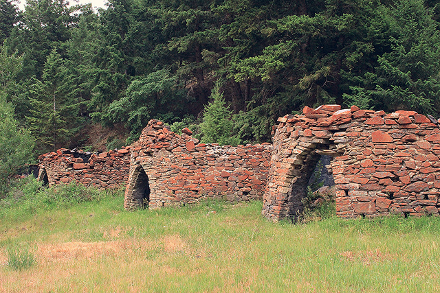
A smelter in the mountains is only as good as its fuel supply, and in 1882 contractors built a battery of nine conical stone “beehive” charcoal kilns about a mile above the works, each some 20 feet across and 20 feet tall, laid up from coursed fieldstone and locally fired brick. Timber cut from the surrounding slopes was floated down an engineered wooden flume and packed into the kilns; by one park estimate, 48 men were tied up cutting wood and burning roughly 80,000 bushels of charcoal. The kilns are not just scenery — they’re the clearest surviving evidence of the hidden cost of Western smelting, where every ton of metal depended on whole forests, flumes, woodcutters, and teamsters. (Coke eventually replaced local charcoal, and the kilns were abandoned by the mid-1890s.)
Bayhorse’s 1882 charcoal kilns — coursed fieldstone and fired brick, built to fuel the smelter. Photo: Sassygirljenna, Wikimedia Commons, CC BY-SA 4.0.
In 1882 the Ramshorn passed to stage-line entrepreneurs John T. “Jack” Gilmer and Orange James “O. J.” Salisbury, veterans of the Holladay and Wells Fargo transportation businesses, who built Bayhorse’s concentration mill that year. In 1883 they completed a wire-rope aerial tramway — in full operation by September 1 — carrying ore buckets from the high Ramshorn and Skylark workings (between about 7,200 and 9,000 feet) down the mountain to a bin by the creek, where teams hauled it to the mill and smelter. The Ramshorn itself grew into one of Idaho’s deep, heavily developed mines — a maze of tunnels and levels dropping well over a thousand feet — and remains the subject of C. P. Ross’s foundational 1937 USGS study of the district’s geology.
The “Wells Fargo building.” Visitors are often told that the stout stone building with the thick mortared walls was a Wells Fargo bank or bullion vault. Be a little careful with that. Gilmer and Salisbury had acquired Holladay/Wells Fargo transportation interests and may well have built or run the structure, and its heavy walls would suit a strongbox — but the careful park history notes that its precise original function has never actually been established. “Wells Fargo building” is a reasonable local interpretation, not a documented fact.
Collapse in 1889 — and why it wasn’t just “demonetization”
Bayhorse’s first real collapse came in 1889, and it’s worth getting the cause right, because the usual shorthand is wrong. On May 14 a fire tore through the lower town, destroying dwellings, a stage barn, Sing Lee’s wash house, and a teamsters’ mess; a drought that summer dropped the creek so low the water-powered mill had trouble running. Then the sharp blow landed: in November 1889, following a U.S. Treasury ruling by Secretary William Windom concerning imported Mexican silver-lead ores, Bayhorse was — in the National Register’s words — “practically deserted” within about two weeks, with more than 300 men thrown out of work, and the isolated canyon operations couldn’t simply restart over winter.
“Silver was demonetized and the town died” — not quite. The national silver crisis was real: the 1893 repeal of the Sherman Silver Purchase Act and the depression that followed hammered silver mining across the West. But it’s misleading to pin Bayhorse on a single act of “demonetization.” The local breakdown began in 1889 — four years before the 1893 federal crisis — and even then it was a tangle of causes: fire, drought, the Windom tariff ruling, weak metal prices, thin ore, and above all that crushing $47-a-ton freight bill. The smelter actually limped on, re-firing between 1893 and 1897 before closing for good in 1897 because of transportation costs; ore then went seventeen miles to the custom smelter at Clayton until that too shut in 1902.
The town that kept coming back
What makes Bayhorse unusual is that it never fully quit. The Idaho State Historical Society records revivals around 1910 and again in 1920–1925, together adding some $2.5 million to the roughly $10 million the district had already produced by 1898. The serious comeback began around 1912; after World War I the school reopened, the post office stayed on, and Ramshorn production climbed to more than 5,000 tons of crude ore a year for a time. In the 1920s the Ramshorn Mines Company rebuilt the old Gilmer & Salisbury mill with modern flotation cells — which could finally recover silver and copper from the low-grade siderite-tetrahedrite that earlier crews had thrown onto the waste dumps — and put up new housing, including the Caretaker’s Residence that still stands.
But the canyon’s oldest problems never went away. By 1926, water shortages were again slowing the mill and falling metal prices made it impractical to continue, and operations were suspended — by then nearly 100,000 tons of ore had come out, leaving more than 25,000 tons of tailings. Even that wasn’t quite the end: lessees prospected through the 1930s and ’40s, Bayhorse Mines, Inc. built another mill and ran limited production from 1951, Bunker Hill tested the Beardsley and Pacific in 1957, and up to 25 people lived here in parts of the 1950s. Umont Mining explored into the early 1960s, and fluorite drew interest as late as the 1970s and ’80s — but by then the resident population had dwindled to a single caretaker, and the town had become a ghost.
Timeline
1864
Prospectors note mineralization along the creek; the “two bay horses” name tradition begins.
1872–73
W. A. Norton locates the first formal claims; a lode is recorded in 1873.
1877
The rich Ramshorn lode is located in the spring; the Bayhorse–Clayton district organizes Oct. 1.
1878–79
Ramshorn ore ships to Salt Lake at ~$800–900/ton — but freight runs $47 a ton.
1880
Omaha Smelting builds the district’s first smelter; the town takes shape around it.
1882
Gilmer & Salisbury acquire the Ramshorn and build the mill; nine charcoal kilns are erected.
1883
The aerial tramway from the high workings opens (Sept. 1).
1885
A refinery lets the works ship finished silver bars; the town is at its peak (~400).
1889
Fire, drought, and the Windom tariff ruling leave Bayhorse “practically deserted”; 300+ laid off.
1893–97
The silver crisis deepens; the smelter re-fires intermittently, then closes for good in 1897.
1910–1925
Revivals (notably Ramshorn Mines Co.) add ~$2.5M; a 1920s flotation mill is installed.
1926
Water shortages and low prices suspend milling; ~100,000 tons had been mined.
1930s–60s
Intermittent leasing and exploration; the population fades to a lone caretaker.
1976
Bayhorse is listed on the National Register of Historic Places (March 15).
2006–07
Idaho State Parks acquires the townsite and mines (about 547 acres).
2009
After stabilization, the Bayhorse Unit opens to the public.
Seeing Bayhorse now
Bayhorse is open to the public, but think of it as an outdoor industrial-archaeology site rather than a village of restored, enterable buildings. Idaho State Parks keeps the roughly fourteen major structures in “arrested decay” — stabilized so they don’t fall down, but not rebuilt into replicas — so you walk the canyon on marked trails, read the numbered interpretive posts, and look rather than touch. The two things that surprise first-time visitors are the tall mill and the row of stone kilns: together they make plain that this was a vertically integrated industrial community, not a scatter of prospectors’ cabins.
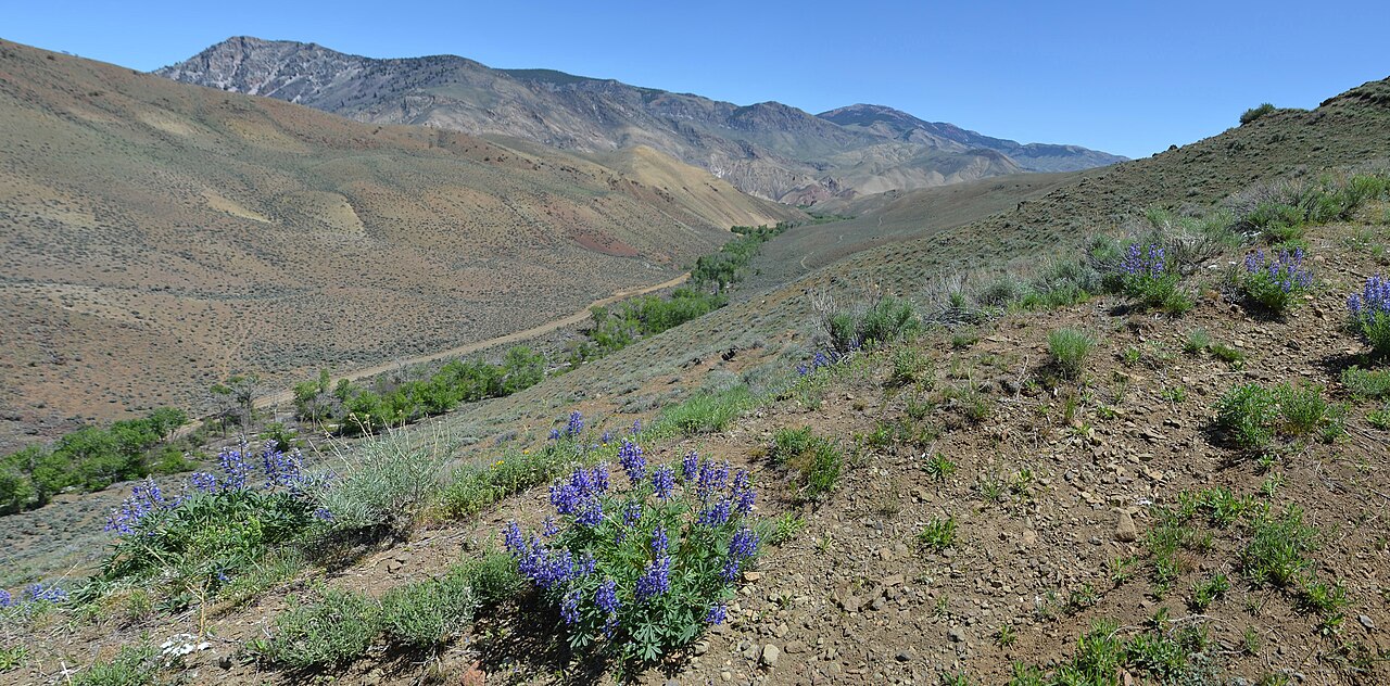
The Bayhorse Creek canyon — the narrow, remote drainage you drive up to reach the townsite. Photo: Bureau of Land Management (BLM Idaho / A. Hedrick), public domain.
Plan your visit
Where It Is
Custer County, about 14 miles southwest of Challis, in a canyon of the Salmon River Mountains above 6,000 feet.
Getting There
From Challis: US-93 south ~2 mi, then ID-75 toward Stanley ~8 mi; past milepost 236 cross the Salmon on a single-lane bridge, then up graded Bayhorse Creek Road ~3 mi to the parking lot.
Season & Hours
The townsite opens May 1 and closes in late fall as weather dictates; day-use only, roughly 8:30 a.m. to sunset. Call the park (208-879-5244) before a shoulder-season trip.
Fees
$7 per vehicle (Idaho State Parks), waived with a State Parks Passport; walkers and cyclists free. The Challis interpretive center charges a small separate museum fee.
What’s There
The 1882 mill, nine charcoal kilns (one fully restored), the “Wells Fargo” stone building, the Bayhorse Hotel, the Deardon & McGowan store, the 1920s Caretaker’s Residence, and two cemeteries.
Managed By
Idaho Department of Parks and Recreation — the Bayhorse Unit of Land of the Yankee Fork State Park. Start at the interpretive center near Challis (Wed–Sun).
⚠ Unstable ruins, open mines, and contaminated ground. The surviving buildings have rotted floors, sagging roof trusses, and protruding square nails; the old mine workings are real hazards — shafts, adits, decayed timbering, highwalls. Stay on the designated paths and out of every structure and mine. Just as important: the historic tailings and smelter-slag areas off the trails carry concentrated lead and arsenic, which is why the state spent years defining safe zones before opening the site. Keep children and pets on the paths, and wash your hands before you eat, drink, or smoke. There’s no drinking water at the townsite — bring your own.
Leave it where it lies. This is a protected historic district: removing bottles, nails, ore samples, metal, or pieces of buildings destroys the archaeology and is against the rules. Pack out everything you bring in (there are no trash bins on site), keep pets leashed to six feet, and camp down-canyon — overnight camping isn’t allowed in the townsite, but the BLM’s Bayhorse Recreation Site on the Salmon River ($10/night) and Forest Service campgrounds up at Bayhorse Lake make good bases. If you ride in: motorized routes here are signed and route-specific, so cross-country travel and riding among the ruins or through the cemeteries are prohibited — follow the official trail map and posted signs.
The Bayhorse townsite, up Bayhorse Creek southwest of Challis in central Idaho.
Nearby ghost towns & mining sites
Clayton
~11–17 mi SW
Bayhorse’s partner in the lead-silver district — still a small living community rather than a ghost town, with the Clayton Silver Mine headframes, remains of the 1880 Clayton smelter that took Bayhorse ore, and a small mining museum.
Custer
~19–27 mi W
The best-preserved Yankee Fork gold ghost town and the natural companion trip, with restored cabins, a schoolhouse museum, a cemetery, and the General Custer mill remains. Gold here, silver at Bayhorse — the two halves of central Idaho mining.
Bonanza
~21–25 mi W
Custer’s older sister city on the Yankee Fork. Fires in 1889 and 1897 destroyed much of it, so less survives, but its pioneer cemetery — with graves from the 1880s fires and epidemics — is worth the stop.
Yankee Fork Gold Dredge
~18–26 mi W
A 988-ton floating bucket-line dredge assembled in 1940 that chewed through about five miles of Yankee Fork gravels before stopping in 1952. Its colossal scale is the perfect contrast to Bayhorse’s hand-worked hard-rock mines.
Sunbeam Dam
~20–23 mi W
A short-lived mining-power dam finished in 1910 to run a mill, failed by 1911, and later breached to restore salmon passage — the only dam ever built across the main Salmon River. The breached concrete abutments still stand beside ID-75.
Mackay / White Knob
~48 mi SE (straight-line)
A copper-silver district with the BLM’s self-guided Mine Hill auto tour — smelter site, aerial-tramway towers, tunnels, the White Knob townsite, and a rebuilt Shay railroad trestle. Far longer by road than the map suggests, and some routes are ATV-only.
Custer, Bonanza, and the dredge are the natural day’s loop with Bayhorse — Idaho State Parks interprets them together for a reason. For more ghost towns on the archive, see Old American Falls, Silver Reef, and Bodie.
Further reading
Histories, geology, archives & primary records
Bay Horse and Clayton — Idaho State Historical Society Reference Series No. 169 (1980)
A concise, well-grounded institutional history: the name story, Norton’s claims, the 1877 discoveries, Ramshorn production, and the brutal $47-per-ton freight cost.
Bayhorse Historic District — National Register of Historic Places nomination (1976)
The key preservation document for the town’s 1880s layout, businesses, smelter, kilns, the 1889 collapse, surviving architecture, and the ~400 peak-population estimate.
Geology and Ore Deposits of the Bayhorse Region, Custer County, Idaho
C. P. Ross · U.S. Geological Survey Bulletin 877 (1937) — the foundational technical treatment of the anticline, the ore bodies, and the Ramshorn and Skylark workings.
History of the Mines in the Bayhorse Area, Custer County, Idaho
Victoria E. Mitchell · Idaho Geological Survey (1999) — the focused modern history of the mines, from 1877 claims through the twentieth-century operations; pair with her Clayton study.
Mining in Idaho — Idaho State Historical Society Reference Series No. 9 (rev. 1985)
A compact statewide chronology placing the Bayhorse–Clayton district in context, including production through 1898 and the later revivals.
Gold Camps & Silver Cities
Merle W. Wells · Idaho Bureau of Mines and Geology, Bulletin 22 (1983) — the standard history of Idaho’s nineteenth-century mining frontiers, including the Custer County camps.
Land of the Yankee Fork & the park’s historical narrative
Esther Yarber’s regional classic and the IDPR / Friends of the Yankee Fork interpretive narrative — the fullest account of the surviving buildings, site maps, and walking tour.
Sources:
National Register of Historic Places, Bayhorse Historic District nomination (1976) — NPGallery, npgallery.nps.gov.
Idaho State Historical Society Reference Series — “Bay Horse and Clayton” (No. 169) and “Mining in Idaho” (No. 9), history.idaho.gov.
Land of the Yankee Fork historical narrative (IDPR / Friends of the Yankee Fork), idahofriends.org; Land of the Yankee Fork State Park, parksandrecreation.idaho.gov.
C. P. Ross, Geology and Ore Deposits of the Bayhorse Region (USGS Bulletin 877, 1937), pubs.usgs.gov; Victoria E. Mitchell, History of the Mines in the Bayhorse Area (Idaho Geological Survey, 1999). BLM Bayhorse Recreation Site and abandoned-mine safety guidance, blm.gov. Coordinates per Wikipedia.
Photo credits: Hero (Bayhorse mill) and charcoal kilns — Sassygirljenna, Wikimedia Commons, CC BY-SA 4.0. Bayhorse Creek canyon — Bureau of Land Management (BLM Idaho / A. Hedrick, Challis Field Office), public domain.
← Explore more ghost towns