Dividend, Utah: The Company Town Named for a Silver Payout
UtahGold & Silver MiningPrivate mining ground · Active operations·~11 min read
Quick facts
Claims staked / company formed1907 (Tintic Standard Mining Co., October 1907)
Blind ore strike1916, below the 1,000–1,200 ft levels
Called DividendBy September 1918
Built byEmil J. Raddatz and Tintic Standard
Peak populationAbout 500 (around 1930)
Principal mining ended1947–1949
Town dismantledFrom 1947; houses moved to valley towns
Last standing town structureMiner’s Dry (1979 survey); delisted 1991
LocationAbout 39.955°N, 112.062°W, East Tintic Mountains
State / CountyUtah / Utah County
What survivesDumps, roads, foundations and mine sites; condition unverified
⚠ Private patented mining ground · Active exploration and processing · Stay on the public road · Open shafts and heavy-metal waste
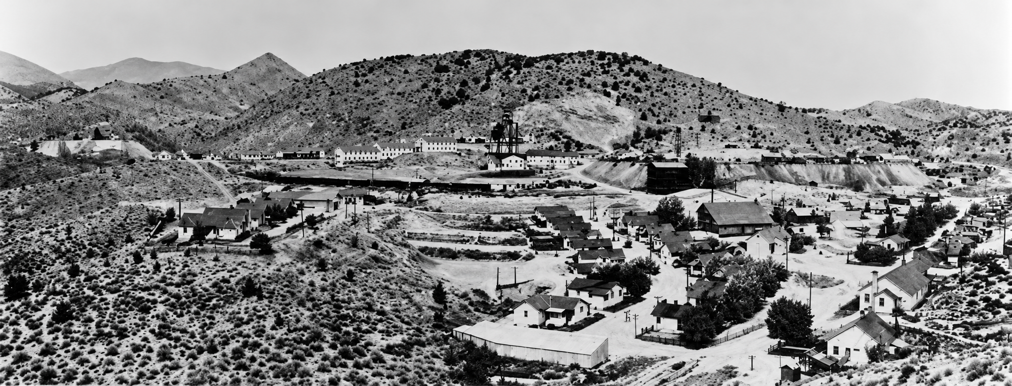
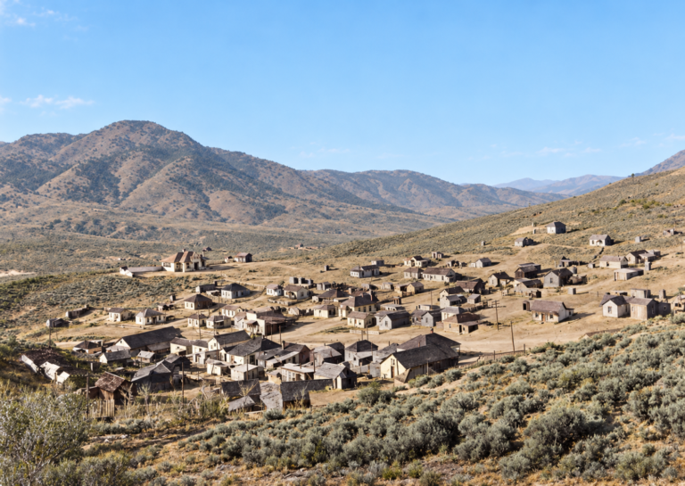
A panorama of Dividend, with rows of company houses below and the mine plant on the slope. The date is not recorded. Original photo: Utah State Historical Society.
Dividend was one of the best-planned mining camps in Utah and one of the quickest to vanish. It was built in the East Tintic Mountains by a single company on the strength of one deep silver-lead strike. Nearly everyone in town worked for that company, rented their house from it, shopped at its store and played on its ball team. When the mine closed, the company moved the houses away.
Few people know the town today, and many who do get its history wrong, often crediting the wrong company. This post sets out what the records support, flags the stories that lack a source, and explains why Dividend is a place to see from the road, if at all.
Raddatz bets on buried ore
The Tintic district was found in 1869 on its western slopes, around Eureka, Mammoth and Silver City, where ore-bearing limestone showed at the surface. The eastern side looked barren. A thick cover of volcanic rock hid the limestone, and prospectors passed it by for decades. Jesse Knight’s 1896 Humbug find showed that ore could lie under shallow cover, and prospectors John and August Bestelmeyer staked claims farther east.
In 1907 John Bestelmeyer brought the ground to Captain Emil J. Raddatz, a German-born mining man, and in October 1907 Raddatz incorporated the Tintic Standard Mining Company. For nearly a decade the company dug through volcanic rock without finding ore. By 1916 it had spent about $407,000, and a county history says Raddatz even mortgaged his Salt Lake City home for another $10,000 to keep going.
The strike came in 1916, below the 1,000- to 1,200-foot levels, where drifts broke through the cover into a large, rich replacement ore body of silver, lead and copper. Dividends began to flow, and one county history counts $1,651,067 paid out through 1921 and more than $19 million over the mine’s life.
On who built Dividend: Popular ghost-town pages say Dividend was a Chief Consolidated town built by Walter Fitch Sr. It was not. The National Park Service’s Tintic survey credits Raddatz and Tintic Standard. Fitch founded Chief Consolidated in 1909 and worked mainly around Eureka, with company housing at nearby Fitchville. The confusion probably comes from the later interlocking ownership of the two companies and from Chief’s Water Lily shaft and lime kilns, which stand close by.
A town built by one company
The camp was first called “Standard.” By September 1918 it was Dividend, with about 200 people, and a seventy-man boardinghouse had gone up in 1916. Tintic Standard owned the land, so it controlled the layout. By the early 1920s a resident recalled mining offices, hotels, a schoolhouse, an amusement hall, a barber shop, a pool hall and seventy-five private houses, with a sewer system in place of privies. The company rented the houses to its employees.
It also ran social life, through the Tintic Standard Club, dances and movies, a baseball field, a golf course, a shooting range and tennis courts. Churches were not built, but different denominations used company buildings. Miners included Cornish, English, Finnish, Italian and Mexican workers.
Wages and loyalty were tied to the company in another way. During the lean years before the strike, employees were sometimes paid partly in Tintic Standard stock, and the county history records one store employee being scolded for taking shares at five cents. This research found no major strike at Dividend; the company housed, paid and entertained its workers.

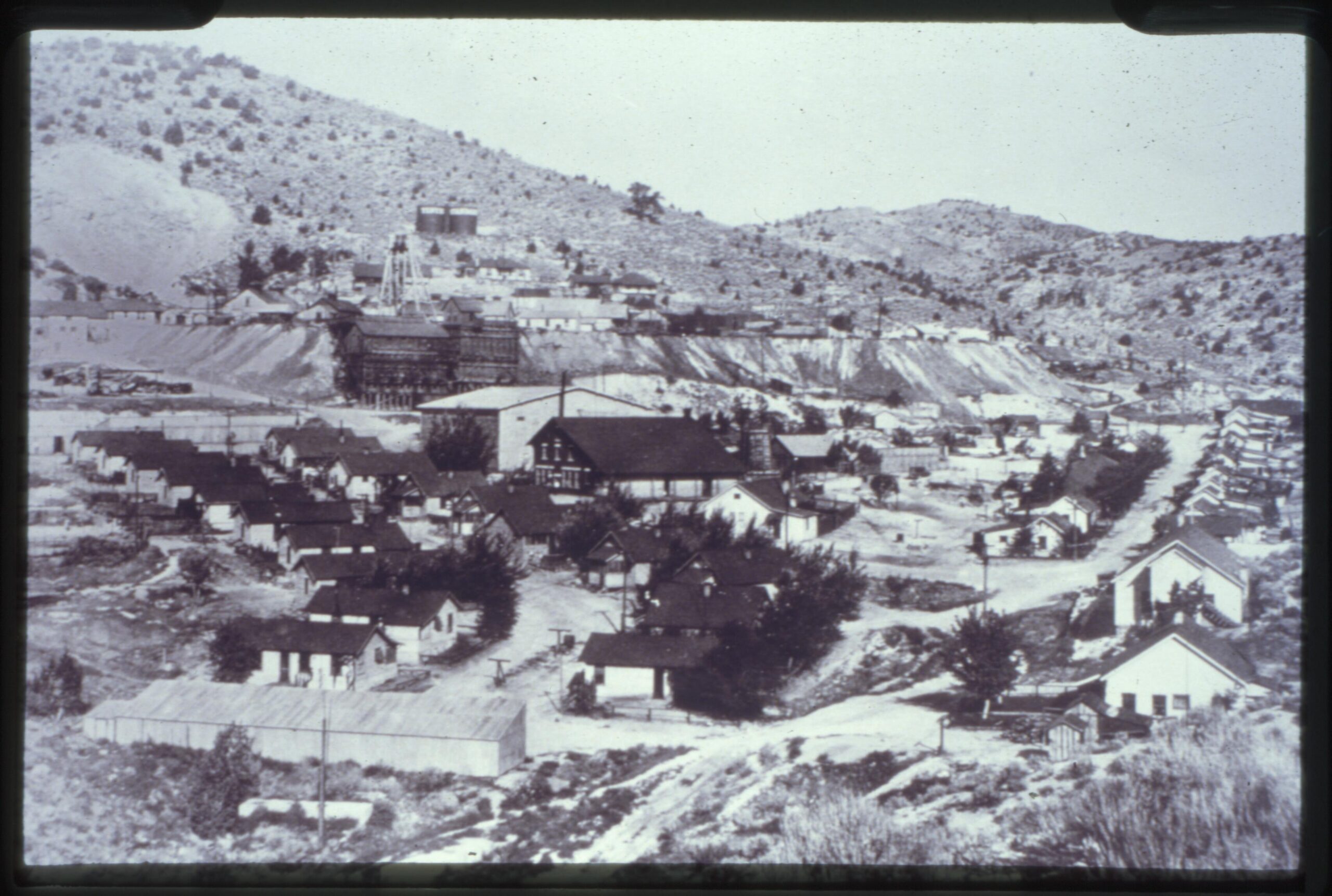
An early view of Dividend, with company houses in the foreground and the mine plant and headframe on the slope above. The date is not recorded.Original photo: Utah State Historical Society
On the town’s size: A few sources say 3,000 or more people lived at Dividend. That figure appears to confuse it with Eureka. A detailed local history gives 499 in the early 1930s, and I did not find a Census table that confirms it, so “about 500” is the safe figure. Another summary gives 500 to 600. The name story is also unsettled: one version says a company contest picked “Dividend” after the first payouts, and another says “Standard” was rejected as too close to Standardville in Carbon County. Neither is documented, though the name clearly refers to the mine’s dividends.
Harold and the failed mill
To treat lower-grade ore, Tintic Standard built the Harold Reduction Mill in Goshen Valley in 1920–21, a chloridizing roast and brine-leach plant that cost about $580,000 and was reportedly named for Raddatz’s son. It treated roughly 200 tons a day by 1922 and employed about 25 men a shift. The process proved too costly for the varied ore, and the mill closed in 1925. After that the company shipped its ore by rail to smelters in the Salt Lake Valley. The Goshen Valley Railroad, a standard-gauge spur completed in 1919, carried it down to the main line.
The mine had other troubles. Deep workings met gases that displaced oxygen, and an underground fire in 1934 forced the company to seal off part of the lower levels. In 1921, neighboring Chief Consolidated’s Water Lily shaft set a sinking record of 427.5 feet in 31 days, a feat that sometimes gets credited to Dividend.
The 1921 robbery
The best-documented violent event in Dividend’s history happened on the evening of March 9, 1921, when robbers came into the town store. The county history, drawing on the press of the time, says Tintic Standard superintendent John Westerdahl, who was there at the time, was shot and killed, along with pool-hall owner L. P. Peterson, and that store owner John Manson and miner Jesus Fernandez were wounded. A manhunt followed across the Tintic range and Utah Valley.
On the details: One research summary lists only Westerdahl as killed and calls the store “Manson Brothers.” The county history’s account lists two deaths. I have used the two-death version. Later tellings add the killers’ identities and motives, which the surviving record does not settle.
Dismantled, not abandoned
Dividend did not burn or collapse. It was a single-industry town that lost its industry. The county history dates the mine’s closure to 1949, after about 34 years, and the National Park Service puts the town’s active period at roughly 1916–1947, so the late 1940s are the safest description of the wind-down. The post office is reported to have closed in 1951.
The company took the town apart rather than pay taxes on empty buildings. Houses were bought and moved to valley towns such as Elberta, Goshen, Santaquin, Payson and Springville. A resident later recalled buying her family’s house and moving it, then coming back to find plants covering the spot, with scarcely a road to show where it had stood. By the mid-1950s the wooden buildings were gone.
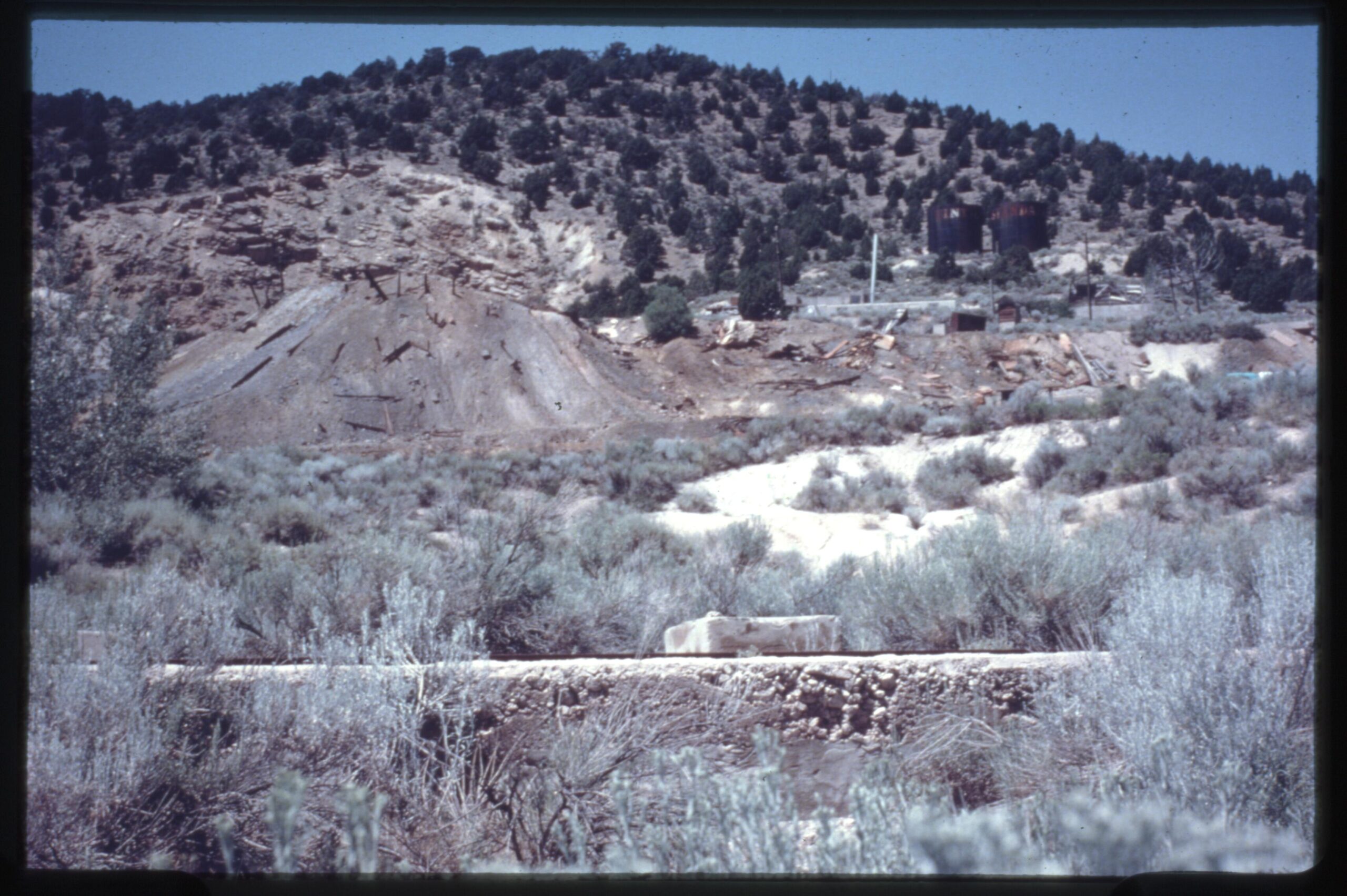
The Dividend site in 1975, with a concrete wall in the sagebrush, a mine dump on the slope and two tanks on the ridge above.Original photo: Utah State Historical Society
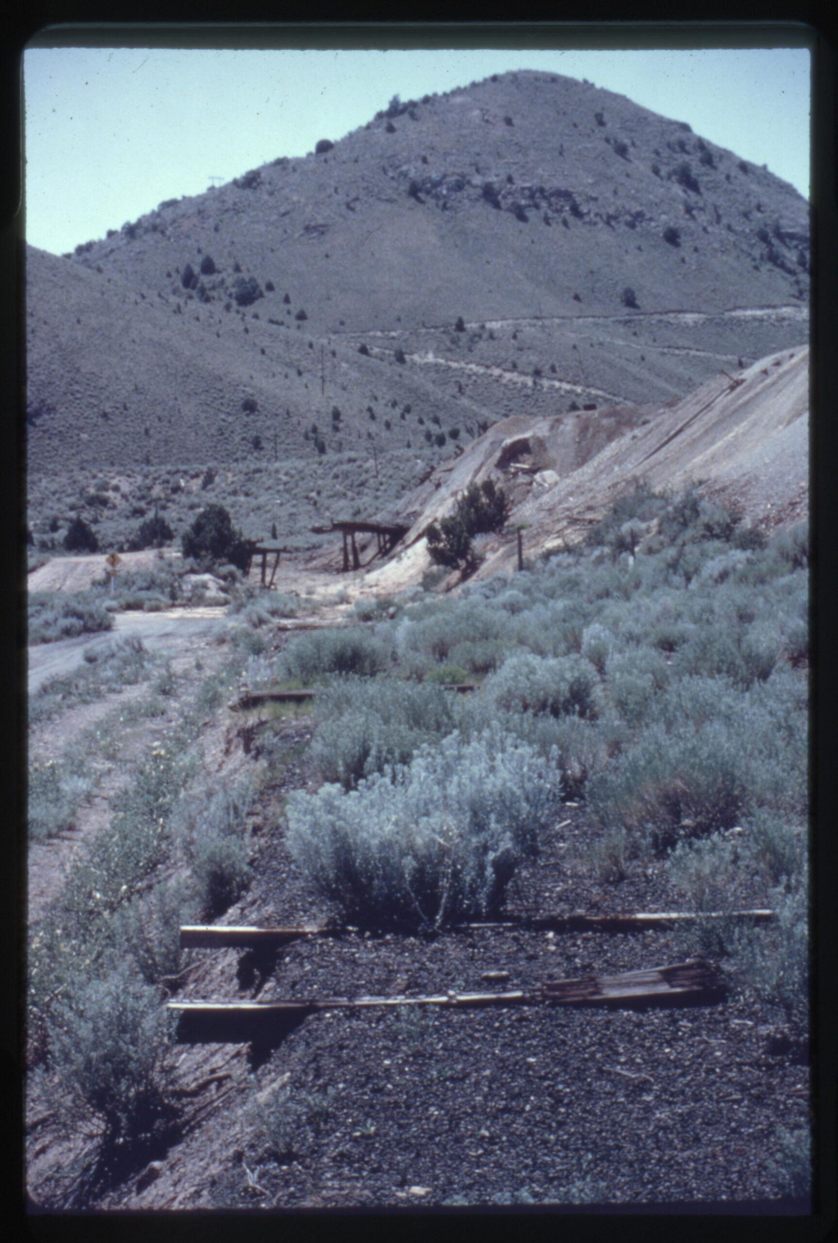
The old railroad grade at Dividend in 1975, with a few loose timbers left on the roadbed.Original photo: Utah State Historical Society
What is left
The best hard evidence is the National Park Service’s 1979 survey of Tintic. It found one town structure standing: the Miner’s Dry, a two-story wood-frame change house of about 1923. It was removed from the National Register in December 1991 along with several other Tintic mining structures. The federal notice does not say whether the building was demolished, collapsed or simply lost its integrity, so the delisting should not be read as proof that it was torn down.
What remains is a mining landscape: dumps, disturbed ground, roads, shaft sites, concrete and industrial footings, and traces of the railroad grade. A field report mentions mining ruins visible along Dividend Road, but this is an observation, not an archaeological inventory, and individual foundations should not be assigned to named town buildings. Several nearby sites often called Dividend ruins belong to other operations, such as the Chief lime kilns and the Water Lily shaft.
On “surviving” structures: One research summary describes an intact reinforced-concrete Miner’s Dry, shaft caps put in by the state, and riveted water tanks with faded “Tintic Standard” lettering still standing. The National Park Service describes the Miner’s Dry as wood-frame and later delisted it. The two tanks visible on the ridge in the 1975 photo above support at least that part, but I could not confirm that any of this stands today. Treat all of it as unverified.
Timeline
1869
Tintic district discovered on its western slopes.
1907
Claims staked; Raddatz incorporates Tintic Standard in October.
1909
Walter Fitch Sr. organizes Chief Consolidated, a separate company.
1916
The deep ore body is struck; a boardinghouse goes up.
1917
First dividends are reported.
September 1918
The camp is called Dividend, with about 200 people.
1919
The Goshen Valley Railroad spur is completed.
1920–1921
The Harold mill is built.
March 9, 1921
A store robbery leaves the mine superintendent and another man dead.
1925
The Harold mill closes.
About 1930
Population peaks at about 500.
1934
An underground fire forces parts of the lower mine to be sealed.
1947–1949
Principal mining ends; the company sells and moves the buildings.
1951
The post office is reported closed.
1979
The park service survey finds the Miner’s Dry the only town structure standing.
December 1991
The Miner’s Dry is removed from the National Register.
2022
Osisko Development acquires Tintic Consolidated Metals and Chief Consolidated.
Visit guide — Dividend, Utah
Can you visit?Only the public road. The townsite, dumps, shafts and foundations are private patented mining ground in an active exploration and processing area. No agency lists Dividend as an open heritage site, and leaving the road to walk among the ruins is trespass.
Getting thereFrom the east, take US-6 at Elberta, go south on SR-68 for less than half a mile, then west on Dividend Road. A reported figure is about 4.5 miles of graded gravel and dirt. From the west, the road connects with US-6 near Homansville Canyon. The old mine roads around it are tangled, so a line on a navigation app does not mean a road is public.
CoordinatesAbout 39.955°N, 112.062°W (from the old Miner’s Dry listing)
Road conditionsGraded dirt and gravel with washboard and rocks. Passenger cars are reported to manage it in dry summer weather, but storms, mud and winter snow can stop anything but high-clearance four-wheel drive. No live road-condition service covers it, and side tracks may not be maintained or open.
Land statusMost of East Tintic is held by one operator. Its late-2024 filings describe roughly 18,800 acres of patented claims, and a draft 2026 state permit describes underground mining, ore storage, crushing, leaching and metal recovery, with Dividend Road shown beside the operating areas. Posted signs and gates override any map.
FacilitiesNone. Eureka, a few miles west, and Elberta have limited services.
Best seasonLate spring through early autumn, in dry weather and away from thunderstorms.
Serious hazards: The district has many historic shafts, adits and prospect pits, and the state has capped only some of them. The mine also drew in gases that displaced oxygen, so never enter any opening. Active mine traffic and equipment, unstable dumps, industrial ponds and process areas add to the risk. Rattlesnakes shelter in rubble through the warm months. Two teenagers from nearby Mammoth were killed in 2017 and their bodies left in a shaft in this district; a private memorial is reported there. Please treat that area with respect and stay away.
Respect the ground: Do not pass gates, fences or signs, or walk onto a pad, shaft site or dump because it looks abandoned. Do not take rock, metal or artifacts. Mine waste carries lead, zinc and arsenic, so keep children and pets on the road and wash hands afterward.
Approximate location of Dividend in the East Tintic Mountains, Utah County. The surrounding ground is private mining property; see the visit guide.
Historic sites nearby
Knightsville, UT
~3 miles west, also on this site
Jesse Knight’s saloon-free company camp · School foundation
Mammoth & Robinson, UT
~4 miles west-southwest, also on this site
Tintic’s two-town mining community · Private claims
Eureka, UT
~3 miles west
Living town · Historic district · Tintic Mining Museum
Homansville, UT
~2–3 miles northwest
1870s camp site · Water Lily shaft and Chief lime kilns nearby
Silver City & Diamond, UT
~5–6 miles southwest
Early Tintic camps · Smelter slag and cemeteries
Harold Mill, UT
Several miles east, in Goshen Valley
Tintic Standard’s 1920–25 reduction mill site
Silver City, UT
~6 miles west-southwest, also on this site
Tintic’s first camp · Knight smelter and mill ruins
Further reading
Books, studies and records about Dividend and Tintic
A History of Utah County
Utah Centennial County History Series — The best compact narrative of Dividend, including the 1921 robbery and resident recollections.
The Towns of Tintic
Beth Kay Harris, 1961 — A town-by-town account of Eureka, Dividend, Mammoth, Silver City, Diamond and Robinson.
General Geology and Mines of the East Tintic Mining District, Utah
H. T. Morris and T. S. Lovering · USGS Professional Paper 1024, 1979 — The technical source for the Tintic Standard ore body.
Tintic Mining District, in From the Ground Up: A History of Mining in Utah
Philip F. Notarianni · Utah State University Press and University of Utah Press, 2006 — A modern scholarly overview.
Historic Resources of the Tintic Mining District
National Park Service, 1979 — The survey that identified Raddatz as the town builder and recorded what stood.
Walter Fitch papers, 1894–1937
American Heritage Center, University of Wyoming — Chief Consolidated records, useful for telling the two companies apart.
DividendUtahGhost TownUtah Ghost TownsUtah CountyEast Tintic Mining DistrictTintic Standard Mining CompanyEmil RaddatzCompany TownSilver Mining
Sources
National Park Service — Historic Resources of the Tintic Mining District (1979) — Raddatz as town builder, the Miner’s Dry, the Water Lily shaft and the Chief kilns
Internet Archive — A History of Utah County — the 1907 beginnings, the 1916 strike, company-town life, the 1921 robbery and the 1949 closure
UtahRails.net — Tintic History, 1977 — district chronology
UtahRails.net — Tintic, Eureka Lily Mining Co. — the Chief and Tintic Standard interests
Archives West — Walter Fitch papers — Chief Consolidated records
U.S. Securities and Exchange Commission — Tintic project technical report (2021) — district access and open-opening hazards
Utah Division of Water Quality — Draft permit for the Tintic facility (April 2026) — the modern processing operation beside Dividend Road
Additional detail draws on the two research compilations assembled for this post. Where they disagree, as on the town’s builder, population, closure date, the 1921 deaths and what survives, the better-supported version is used and the difference is noted above. Distances to nearby sites were calculated from coordinates. Historic photographs courtesy of the Utah State Historical Society.