Knightsville, Utah: Jesse Knight’s Saloon-Free Mining Camp Above Eureka
UtahGold & Silver MiningMormon SettlementsPermission needed · Mine hazards·~12 min read
Quick facts
Founded1896–97 by Jesse Knight
WhereGodiva Mountain, East Tintic Mountains, about 2 miles east of Eureka
Key mineThe Humbug, with the Uncle Sam, Beck Tunnel, Colorado and Iron Blossom nearby
Known forNo saloons, a Sunday shutdown, and a 25-cent wage premium
Peak populationAbout 1,000 around 1907 (an estimate)
Post officeJanuary 1907 to May 1924
School built1909, concrete with mine-dump rock
Jesse Knight diedMarch 14, 1921
AbandonedBy about 1940
National RegisterKnightsville School Foundation, March 14, 1979 (#79003485)
Elevation~6,742 ft
State / CountyUtah / Juab County
What survivesThe school foundation, terraces and retaining walls, artifact scatters, mine dumps and workings
⚠ Access is not open to everyone · Written permission is posted for the schoolhouse · Unfenced shafts · Lead-bearing mine waste
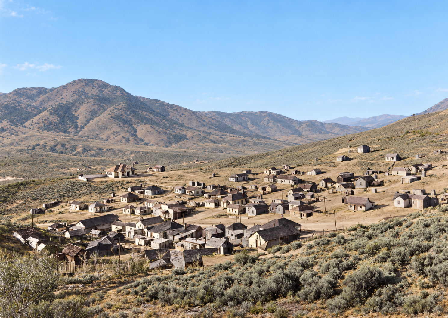
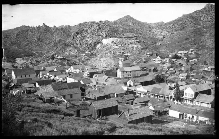
Knightsville, with rows of frame cottages spread across the slope of Godiva Mountain. Colorized with AI; the colors are an interpretation. Original photo: Utah State Historical Society.
Most mining camps of the 1890s were built fast and left to fend for themselves. Knightsville was planned. It sat on the barren north slope of Godiva Mountain, two miles above the roaring camp of Eureka, and it belonged to one man. Jesse Knight owned the ground, the mines and the town, and he used that control to do something unusual: he kept the saloons out.
That reputation made Knightsville famous. It also grew into a legend that outran the record. This post separates what the documents support from what the stories added, and it explains why a camp that held about a thousand people is now a school foundation, a few terraces and a lot of mine dumps.
“…reportedly the only privately owned, saloon-free mining town in the United States.”
How the National Park Service’s National Register nomination describes KnightsvilleThe Humbug, 1886–1896
The Tintic Mining District had been producing since 1869, and its rich ground ran along the western corridors that fed Eureka. The East Tintic ridges were fractured limestone and volcanic contact ground, long written off by professionals as barren. Jesse Knight, born in Nauvoo, Illinois, in 1845 and raised in poverty in Utah Valley, had spent years as a freighter, rancher and merchant. He began prospecting the East Tintic country with his son J. William “Will” Knight, mortgaging his ranch to pay for it.
The story goes that a mining expert ridiculed his work as a humbug, and Knight named the claim the Humbug. A single-jack tunnel into the hanging wall reached a rich body of lead carbonate. An early shipment to the United States Smelting Company reportedly returned more than $11,000, and Knight used the money to buy neighboring ground, including the Uncle Sam, Beck Tunnel, Colorado, Iron Blossom and Dragon claims. One account says the Iron Blossom alone paid more than $2.3 million in dividends between 1906 and 1916.
On when the Humbug was found: Dates differ because writers mean different things by “discovery.” Richard Peterson’s biography in the Utah Historical Quarterly says Knight found the Humbug in 1886 but lacked the capital to develop it for years. Gary Reese’s 1961 BYU thesis names 1896 as the decisive year. Newspaper evidence shows Knight filing claims in the Fish Springs and Tintic areas as early as 1891 and filing notices for the Humbug lode in 1894. The best reading is an earlier claim and a later strike that made the property famous.

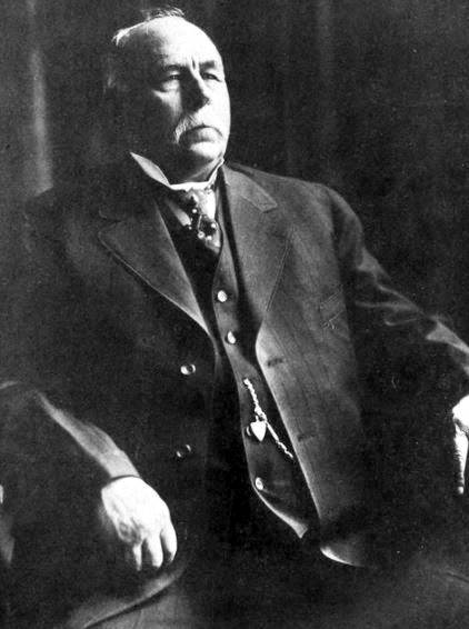
Jesse Knight, about 1913.Original photo: Utah State Historical Society
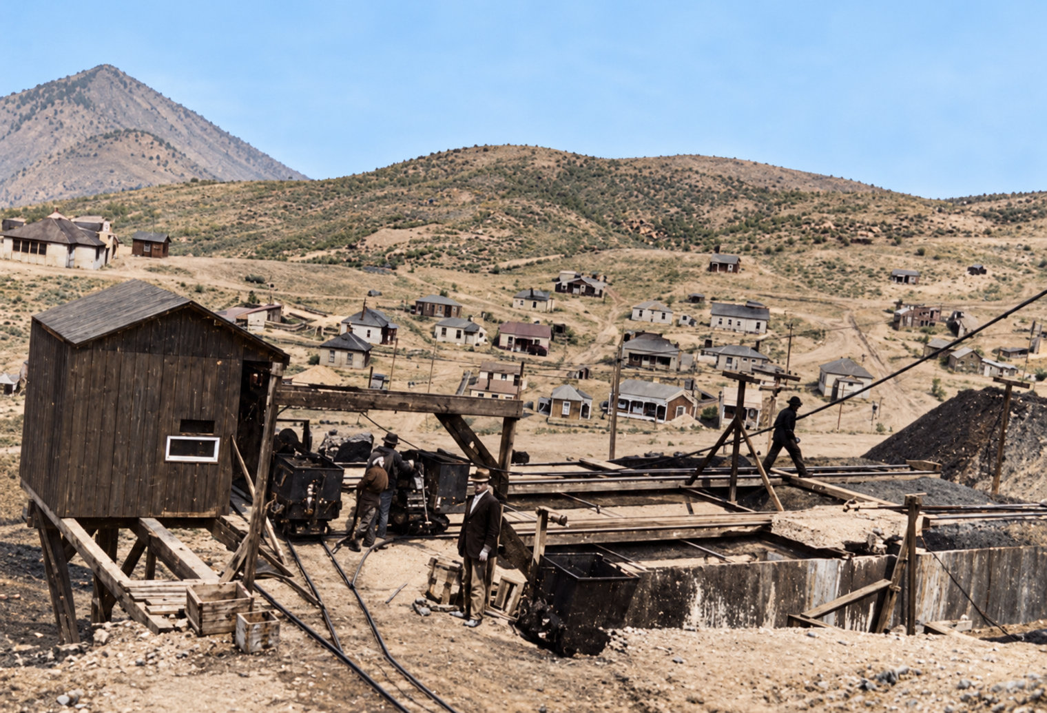
Mine works in the foreground, with the company town stepped across the hillside behind. Colorized with AI; the colors are an interpretation.Original photo: Utah State Historical Society
A company town, 1896–1908
Knight platted a company townsite on the mountain in 1896–97, starting with about twenty frame cottages. Between 1906 and 1908 the town held about sixty-five homes, two large boarding houses, several hotels, grocery and dry-goods stores, and a post office that opened in January 1907. The commonly repeated peak population is about 1,000, drawn mostly from Latter-day Saint families attracted by steady work and a clean social setting. Knight paid for a meetinghouse and an amusement hall for family recreation without alcohol, and Knightsville became part of the Tintic Stake.
In June 1909 the school board awarded a $5,500 contract to Logan builder Martin E. Andersen for a concrete schoolhouse, about forty feet square, made with gravel and waste rock from the nearby May Day mine dump. Ore bins, aerial tramways and a narrow-gauge railroad tied the East Tintic mines to Knight’s Tintic Smelter at Silver City, which he built in 1908.
On the population: The figure of about 1,000 around 1907 comes from regional histories, including Wilson, McNulty and Hampshire’s A History of Juab County. It is an estimate, not a census count, and no precise municipal figure is known.
The saloon-free camp
Knight was a devout Latter-day Saint who disapproved of the saloons, gambling halls and brothels in neighboring Eureka. On the ground he owned, he barred them. Miners could still walk down the mountain to Eureka’s taverns, but an employee who was found drunk or squandering his pay while his family went without got a reprimand, and repeat offenders were dismissed.
What set Knight apart in the labor history of the time was the other half of the bargain. He closed the mines on Sunday, which earned them the nickname “Sunday School Mines,” and paid his miners 25 cents a day above the prevailing wage so the day off cost them nothing. One account gives daily pay of $3.00 for surface labor, $3.25 for underground work and $3.50 for skilled machine men and timbermen. He did not deduct hospital or insurance fees from pay envelopes, and he paid medical costs directly. Peterson records that in September 1909 the company paid an injured worker’s hospital bills and half his wage, $1.25 a day, during his stay. Knight’s policies were notable in a district with real labor conflict, and they largely kept his mines out of the strikes that hit other Tintic operations.
On “only saloon-free camp in the world”: That line is promotion, not documented fact. The National Park Service says Knightsville was “reportedly” the only privately owned, saloon-free mining town in the United States. Utah’s state history program says “probably” the only saloon-free, brothel-free mining town in the nation. John Van Cott’s Utah Place Names is more modest and calls it one of two Utah mining camps without saloons or red-light districts. The absence of saloons is well documented; the superlatives are not.
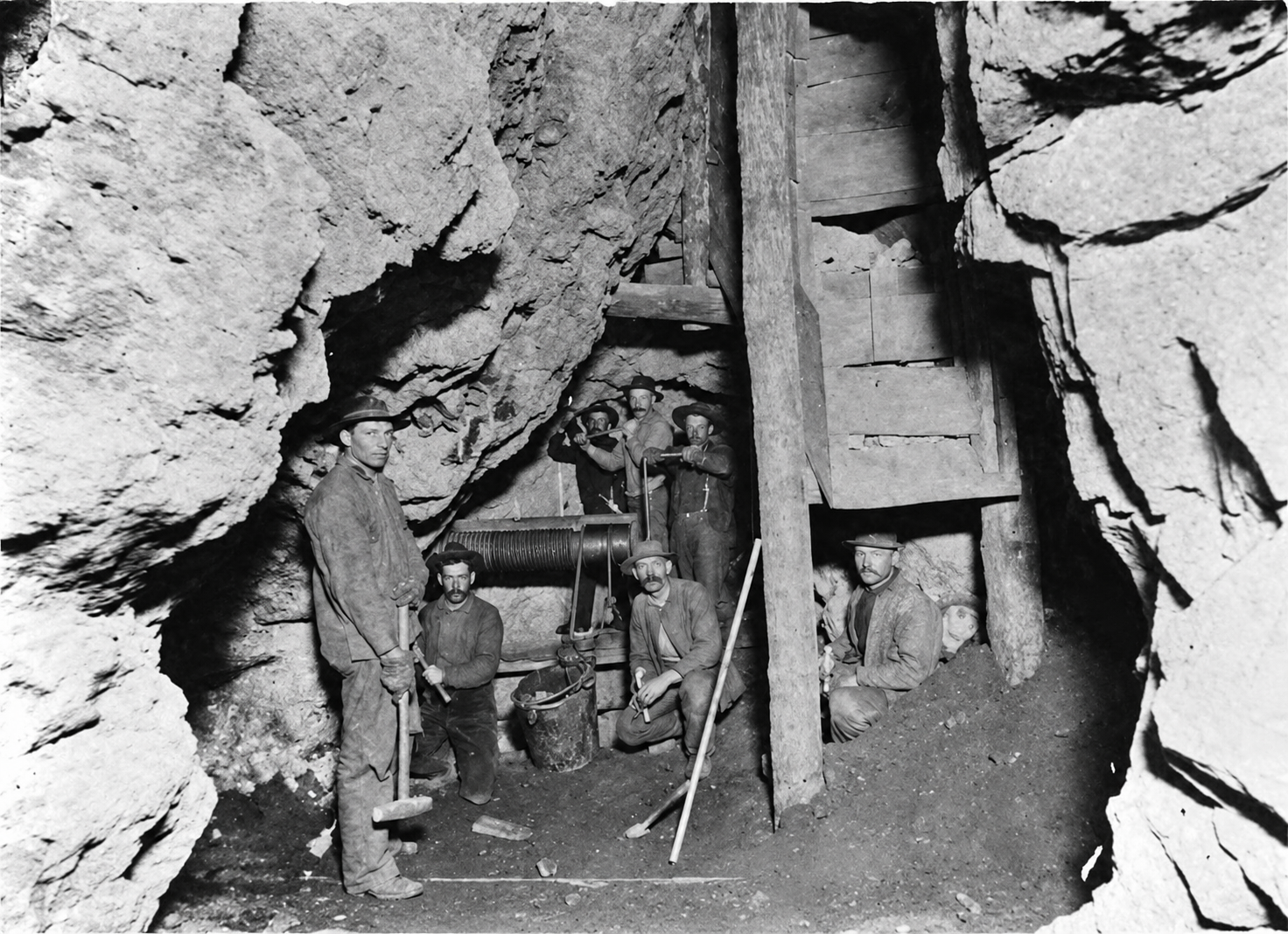
Miners working underground beneath heavy timber supports, with hand tools and a hoist drum. Black and white original.Original photo: Utah State Historical Society
Folklore and the “Mormon Wizard”
Locally, Knight was “Uncle Jesse,” and in regional tradition the “Mormon Wizard,” an unlettered prospector led to hidden ore by divine guidance. The legend runs that he was an inactive Latter-day Saint whose faith was renewed during a daughter’s serious illness in 1887, that he promised to devote his life to God if she recovered, and that a voice or three identical dreams then guided him to a barren ridge on Godiva Mountain. Some tellers add that he could point his walking stick at blank limestone and tell miners where to drift.
Knight’s faith is documented, and so is his own providential reading of his success. The record also shows a practical prospector who had spent decades as a teamster and rancher, filed claims years before the Humbug paid, and traced the contact between limestone and porphyry to find ore bodies hidden under barren caps. Peterson takes the belief seriously but warns that it is not an adequate historical explanation by itself. What can be shown is the money that followed: Peterson calculates that Knight gave more than $500,000 to Brigham Young University between 1898 and his death in 1921, and Reese documents help to the Church and other investments.
On the stories: The dream or manifestation is best treated as Knight’s religious belief and a family tradition, not independently verified history. A well-known joke has Simon Bamberger saying Knight might not have had a mine when he found the Humbug but certainly had one when he sold it. That line survives in later biography and is not a verified quotation. Local anecdotes that Knight hired a man with eight children to satisfy school enrollment, and that he fired workers for drinking, rest largely on county-history tradition and should be repeated with care. There is also no good evidence of a formally constituted “miners’ relief fund”; what is documented is company-paid medical help and partial wages case by case. Knightsville was not crime-free either: in late 1903, after Eureka closed saloons on Sundays, rumors of a speakeasy in Knightsville led the Eureka Reporter to print denials.
Decline, 1915–1940
The camp rose and fell with the ore. By about 1915 the high-grade carbonate bodies were weakening, costs of timbering, hoisting and pumping climbed as work moved into harder sulfide ore, and people began leaving. Knight died on March 14, 1921, removing the owner who had kept marginal mines working to maintain jobs. Houses were jacked up, set on log rollers and wagons, and hauled about two miles down the mountain to be re-set on lots in Eureka. By 1924 only two local mines were running, and the post office closed in May of that year. A few leasers and caretakers stayed through the 1930s, and commercial mining ended by about 1940.
Knightsville did not burn or collapse. It was taken apart, moved and salvaged until what was left was a ruin.
What is left on Godiva Mountain
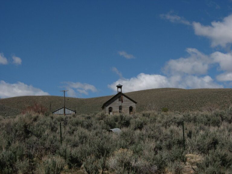
The best-documented surviving structure is not a building. It is the concrete and aggregate foundation of the 1909 school, listed on the National Register of Historic Places on March 14, 1979, as part of the Tintic Mining District. The nomination called it the “only remnant” of Knightsville. Around it, cut-and-fill terraces and dry-laid stone retaining walls mark the benches where houses and stores stood. A scatter of square nails, amethyst-tinted glass, rusted barrel hoops, iron hardware and chimney brick covers the slopes. Waste-rock dumps from the Humbug, Uncle Sam, May Day and Godiva mines dominate the terrain, with rotted timbers, cables and collapse craters over old stopes.
Knightsville had no cemetery. Because Eureka was so close and many families had roots in Utah Valley, the dead were buried off the mountain, with non-Mormon miners often in the Eureka City Cemetery and Latter-day Saint families at burial grounds in places such as Goshen, Santaquin, Payson and Provo.
On what you may see in the area: The broader mining landscape around Eureka has mine dumps and capped waste piles from the EPA’s Eureka Mills Superfund work, with soil cleanup completed in 2010 and sediment ponds near Knightsville and Gardner canyons. Those are features of the mining landscape. They should not be mistaken for the foundations of Knightsville houses.
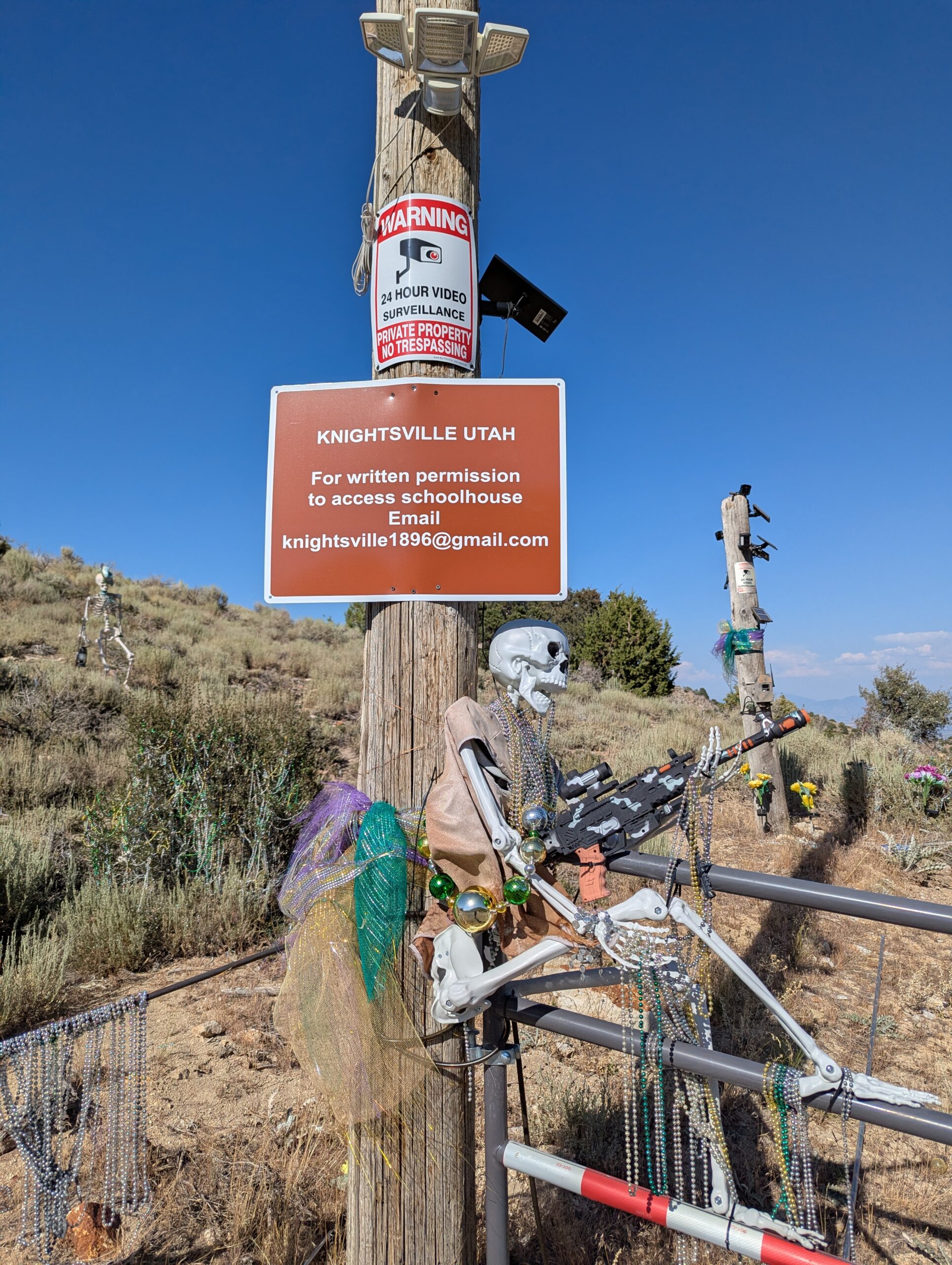
A 2025 view of the road to Knightsville. A sign on the pole directs visitors to seek written permission to access the schoolhouse, and a warning notice is posted above it.Photo: Ghost Town Archive, 2025
Timeline
1845
Jesse Knight is born in Nauvoo, Illinois.
1869
The Tintic Mining District is organized.
1886–1894
Knight prospects East Tintic; sources variously date the Humbug claim between 1886 and 1894.
1896–97
The Humbug pays and Knight plats the company town of Knightsville.
January 1907
The Knightsville post office opens.
1906–1908
Peak years, with about sixty-five homes and about 1,000 residents.
1908
Knight builds the Tintic Smelter at Silver City.
1909
The concrete school is built by Martin E. Andersen for $5,500.
c. 1915
High-grade ore weakens and outward migration begins.
March 14, 1921
Jesse Knight dies.
May 1924
The post office closes; only two local mines remain active.
c. 1940
Commercial mining ends and the site is abandoned.
March 14, 1979
The Knightsville School Foundation is listed on the National Register.
2002–2010
EPA cleanup of the Eureka Mills Superfund site; soil work completed in 2010.
Visit guide — Knightsville, Utah
Can you visit?Do not assume so. The school foundation was listed as owned by the Anaconda Company when it was nominated in 1979, and Utah land-ownership maps are not title records. A sign on the road in 2025 asks visitors to get written permission to access the schoolhouse. Treat the townsite as private or restricted until you have confirmed otherwise.
Checking ownershipContact the Juab County Recorder (published number 435-623-3430) for parcel ownership, and the BLM’s Mining Law and Mining Land Records System for federal claims. Do not rely on a ghost-town map or a casual website.
Getting thereKnightsville Road leaves Eureka on US-6, heading east on Church Street and climbing roughly 1.5 to 2 miles on a steep, rocky, unmaintained dirt road. Apparent mine roads beyond that can end at restricted parcels.
VehicleHigh clearance is recommended. No official road rating was found, so older ratings online are not proof of condition or permission. The route is rough in winter and during spring thaw.
CoordinatesSchool foundation: about 39.954°N, 112.099°W · elevation ~6,742 ft
Fees and facilitiesNo published entrance fee. There are no restrooms, water or marked campgrounds at the site.
Best legal historical visitStart in Eureka, where the Tintic Mining Museum explains the district, and look at the hillside from public roads. Check museum hours before you go.
Best seasonLate spring through autumn, when dry roads are safest.
Serious hazards: The hillsides hold unfenced prospect holes, hidden vertical shafts, rotted timber caps and decaying tunnels. Never enter an adit, shaft or collapsed opening, even if it looks stable. Ground near old stope margins can subside.
Lead and arsenic: EPA found elevated lead in soils around Eureka, and the dumps and tailings on Godiva Mountain carry heavy metals. Do not dig in tailings, climb capped waste piles or kick up dust, keep children and pets close, and wash hands and footwear afterward. Leave artifacts in place and obey every gate and sign.
Approximate location of the Knightsville School Foundation on Godiva Mountain, east of Eureka, Juab County, Utah. Access is restricted; see the visit guide.
Historic sites nearby
Mercur, UT
~26 miles north-northwest, also on this site
Cyanide gold boomtown · Private mining project
Ophir, UT
~30 miles north-northwest, also on this site
Silver camp · Town Hall (NRHP) · Still inhabited
Bingham Canyon, UT
~40 miles north, also on this site
Utah’s other great mining district, ahead of Tintic in output
Eureka, UT
~2 miles west
Living town · Historic district · Tintic Mining Museum
Mammoth, UT
A few miles south
Historic district · Headframes and terraced cottages
Silver City & Diamond, UT
A few miles south
Tintic Smelter ruins · Early 1870 camps with cemeteries
Mammoth & Robinson, UT
~1.5 miles south, also on this site
Tintic mining camp and its twin town Robinson · Grand Central lawsuit · Private claims
Dividend, UT
~3 miles east, also on this site
Tintic Standard company town · Private mining ground
Silver City, UT
~4 miles southwest, also on this site
Tintic’s first camp · Knight smelter and mill ruins
Further reading
Books, articles and records about Knightsville
“Jesse Knight, Utah’s Mormon Mining Mogul”
Richard H. Peterson · Utah Historical Quarterly 57:3, 1989 — The best single scholarly treatment of Knight, separating legend from business practice.
Uncle Jesse: The Story of Jesse Knight, Miner, Industrialist, Philanthropist
Gary Fuller Reese · BYU master’s thesis, 1961 — The most comprehensive academic biography, drawn from Knight company records.
The Jesse Knight Family: Jesse Knight, His Forebears and Family
J. William Knight · Deseret News Press, 1940 — A foundational family account by Knight’s son. Valuable testimony, not a detached history.
A History of Juab County
Pearl D. Wilson, June McNulty and David Hampshire · Utah Centennial County History Series, 1999 — Source of much of the standard chronology of the camp.
Faith, Hope, and Prosperity: The Tintic Mining District
Philip F. Notarianni · 1982 — The authoritative industrial history of the region.
“The Company Town: A Passing Phase of Utah’s Industrial Development”
James B. Allen · Utah Historical Quarterly 34:2, 1966 — Places Knightsville among Utah company towns.
“Labor Conflict at Eureka, 1886–1897”
Paul A. Frisch · Utah Historical Quarterly 49:3, 1981 — The labor background that makes Knight’s policies stand out.
KnightsvilleUtahGhost TownUtah Ghost TownsJesse KnightTintic Mining DistrictEureka UtahJuab CountyGodiva MountainHumbug MineCompany TownSilver MiningMormon SettlementsNational Register of Historic Places
Sources
National Park Service — Knightsville School Foundation, Tintic Mining District Multiple Resource Area (NRHP #79003485) — 1909 school, owner at nomination, the saloon-free reputation, the “only remnant”
UtahRails.net — Jesse Knight, Utah’s Mormon Mining Mogul (Peterson, Utah Historical Quarterly) — Sunday wages, medical help, philanthropy, patented holdings
UtahRails.net — Tintic Jesse Knight — claims filed from 1891, the Humbug lode notice in 1894, and the Eureka Reporter denials
BYU ScholarsArchive — Uncle Jesse: The Story of Jesse Knight (Reese) — the 1896 Humbug discovery and the family belief in divine guidance
Utah History to Go — Attic Papers Reveal Jesse Knight Ventures — the family version of the discovery story
Utah Digital Collections — A History of Juab County — the standard chronology, the 1,000 estimate, 1915–1940 decline
OnlineUtah — History of Knightsville, Utah — Van Cott’s Utah Place Names entry
U.S. EPA — Eureka Mills Superfund Site, Operable Unit 4 — lead in soils, mine-waste piles and the May Day–Godiva area
Utah Geospatial Resource Center — Utah Land Ownership — why map layers are not title records
Bureau of Land Management — Abandoned mine dangers and mining-claims information
Additional detail draws on the research compilations assembled for this post, which cite Western Mining History, the Mining History Association’s History of Tintic Mining District, the Eureka City recreation plan and other sources. Distances to Mercur, Ophir and Bingham Canyon were calculated from coordinates. Historic photographs courtesy of the Utah State Historical Society; the 2025 photograph is by Ghost Town Archive. Images marked “colorized” were colorized with AI and are interpretations, not original color.