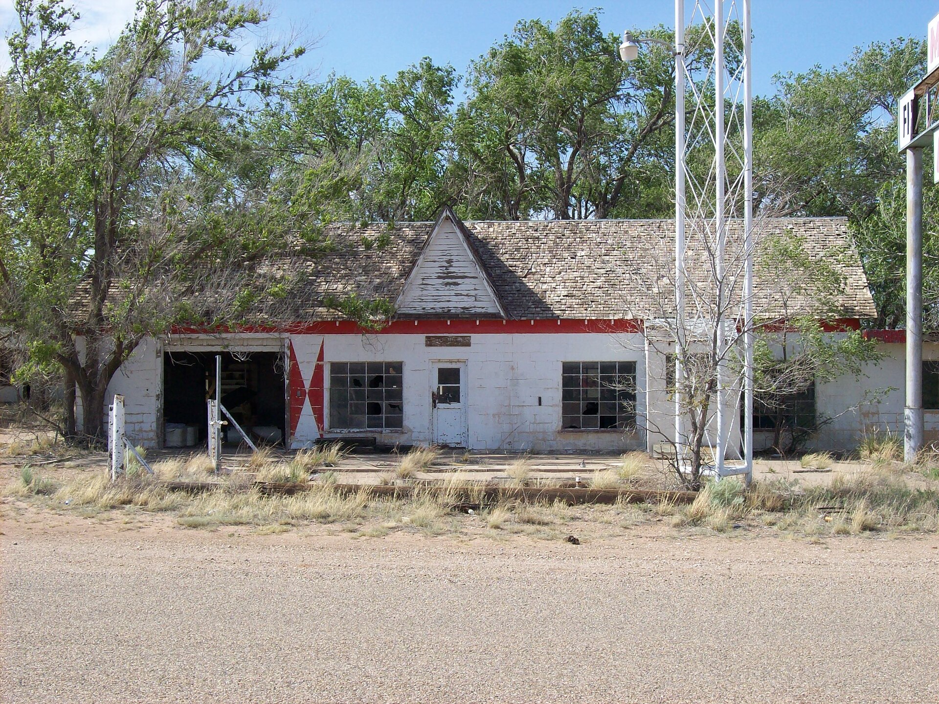
The abandoned motel and 'First Motel in Texas' sign at Glenrio on old Route 66.

Glenrio, Texas & New Mexico
Texas New Mexico Route 66 Mother Road · 1903–1973 13 min read
Founded
Rock Island railroad siding, 1903; named Glenrio ~1908–1910
Peak Population
~100 (railroad era); permanent residents usually ~30–40
Counties / Region
Deaf Smith Co., TX & Quay Co., NM · the Llano Estacado
Elevation
3,855 ft (1,175 m)
Designation
Glenrio Historic District — NRHP 2007 (listed in both states)
Status
Route 66 ghost town; 17 contributing resources, mostly private — viewable from the road
Free — no fee I-40 Exit 0 Paved on the Texas side Gravel/dirt into New Mexico No services on site The 'First/Last Motel in Texas' sign and abandoned buildings of Glenrio on old Route 66.
Glenrio’s abandoned motel and its “First Motel in Texas” sign on old Route 66, at the Texas–New Mexico line. Photo: Wordbuilder, CC BY 3.0, via Wikimedia Commons.

Glenrio is the ghost town that lived through three transportation economies and was killed by the last one. It started as a railroad siding on the high, dry tableland of the Llano Estacado, reinvented itself as a Route 66 roadside oasis, reached its greatest commercial intensity in the postwar automobile boom — and then lost essentially all of its through traffic the moment Interstate 40 slipped past, a fifth of a mile to the north. Within about two years the motels, cafes, and filling stations had gone dark.

What makes Glenrio stranger than the average bypassed town is that it sits directly on the Texas–New Mexico state line — and for decades its businesses used that line as a tool, putting the bars on one side and the gas pumps on the other. This is the documented history of Glenrio, the border lore worth checking against the record, and how to see what survives today.

“Wildorado and Vega and Boise and Glenrio. That’s the end of Texas.” — John Steinbeck, The Grapes of Wrath (1939)

A town built by a railroad and a border, 1901–1910

Glenrio owes its existence to the Chicago, Rock Island & Pacific Railroad’s push west to close the gap between Amarillo and Tucumcari. Rail crews established a siding here around 1903; in 1907 the Rock Island Townsite & Investment Company sent Col. Wells E. Moses to plat the settlement — then called Rock Island — entirely on the New Mexico side of the line. Hotel Kirkpatrick opened in 1908, and when the Amarillo–Tucumcari line was completed in 1910, the railroad built the depot and the community took the name Glenrio, an odd little blend of the Scottish glen (a secluded valley) and the Spanish río (river) — in a place with neither valley nor flowing water.

From the start, Glenrio’s working geography ignored the neatness of the state line — because the line itself was a mistake. The Texas–New Mexico border was legally the 103rd meridian, but an 1859 survey by John H. Clark charted the monument line two to three miles west of the true meridian, creating a contested strip that put the eastern half of Glenrio under Texas rather than New Mexico. New Mexico tried to reclaim it while drafting its 1910 statehood constitution; Congress, under President Taft, settled the matter in 1911 by confirming Clark’s erroneous 1859 line as the legal boundary — leaving Glenrio permanently split between two states, two counties, and two sets of laws.

“Founded in 1903” is shorthand. The tidy line that Glenrio was “founded in 1903 as a Rock Island siding” compresses several events. The railroad project began around 1901–1903; the townsite was platted (as Rock Island) in 1907; Hotel Kirkpatrick opened in 1908; and the depot was built and the place renamed Glenrio only when the line was completed in 1910. Sources split on whether the renaming was 1908 or 1910. Treat 1903 as the start of the railroad project that created Glenrio, not a precise incorporation date.

Two states, one Main Street: the border arbitrage

Because the Texas side (Deaf Smith County) was dry under local-option law, the saloons and dance halls went up a few feet across the line in New Mexico — the State Line Bar and Dance Hall, and a place pointedly named the T. & N. Bar (“Texas and New Mexico”). Gasoline ran the other way: New Mexico kept higher motor-fuel taxes, so the filling stations clustered on the cheaper Texas side, where operators like Joseph Brownlee and the Ferguson family built their pump islands. The post office sat in New Mexico — an annex to the State Line Bar — yet the mail pouches were worked through the Rock Island depot in Texas, so the federal government effectively treated Glenrio as a Texas town.

That same instinct is alive today. After New Mexico legalized recreational cannabis in 2021 and Texas did not, entrepreneurs opened the Glenrio Smoke Stop dispensary on the New Mexico side in September 2023 — and, in 2026, reconstructed and lit a reproduction of Glenrio’s historic “First/Last Stop in Texas” neon sign. The border is still the business plan.

The arbitrage is real — but the absolute version is too neat. “Bars in New Mexico, gas in Texas” captures genuine tax and liquor-law incentives, and authoritative histories repeat it. But the detailed National Register inventory also records a Ferguson gas station (1946) on the New Mexico side of the district. The tax difference strongly favored Texas-side fuel sales; it didn’t build an invisible wall that made a New Mexico gas pump impossible.

The Route 66 boom, 1926–1973

Automobiles were reshaping Glenrio before Route 66 even had its number. The town sat on the Ozark Trails auto network, marked with green-and-white signs by about 1919; when the U.S. numbered-highway system arrived on November 11, 1926, the corridor became U.S. Route 66. The road was paved through the 1930s, realigned in 1930 to eliminate the troublesome railroad crossings around Endee, and widened to a divided section with a narrow concrete median in the early 1950s. Stranded at an isolated midpoint — roughly 73 miles west of Amarillo and 41 miles east of Tucumcari — Glenrio became an essential refueling-and-rest stop for drivers crossing the plains.

The strongest years were about 1945 to 1975, and the surviving buildings tell the story. Around 1950 Joe Brownlee built a Texaco station and then the Streamline Moderne Little Juarez Café (the Brownlee Diner, 1952); Homer Ehresman developed the Texas Longhorn Motel and its State Line Café and gas business in 1953–55. By the 1960s the strip packed in two motels, three restaurants, and at least seven gas stations; old-timers recalled cars stacking five and six deep at the pumps. It was a classic Route 66 phenomenon — a town whose economy was the river of motorists flowing through it, not the handful of people who lived there. Meanwhile the railroad quietly withered: the Rock Island depot closed in 1955, and the rails were pulled up in the 1960s, leaving the grade as a ghost line beside the highway.
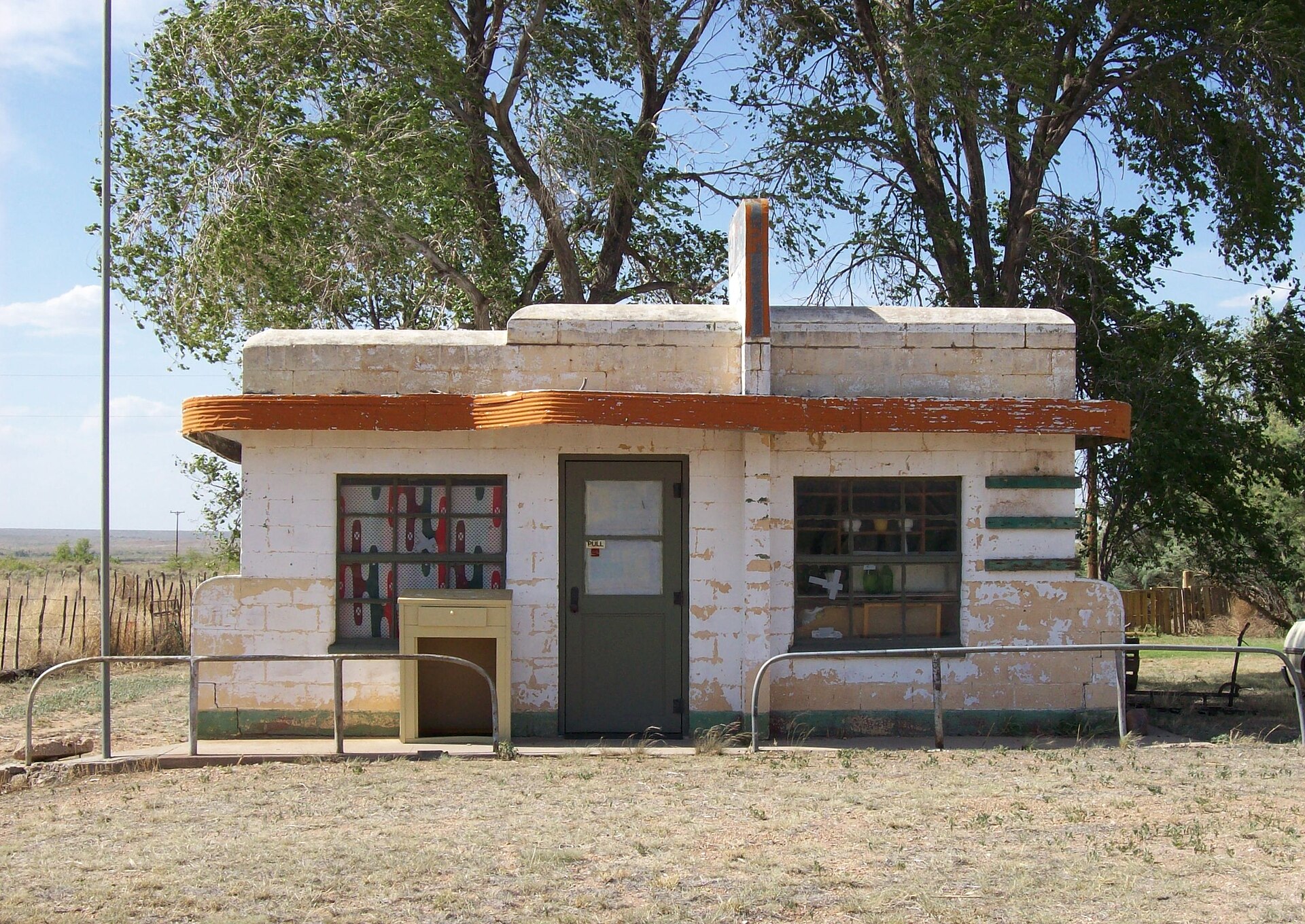
The closed café on Glenrio's old Route 66 strip.
The café building still standing on Glenrio’s strip today — one of the Mother Road businesses that went dark after Interstate 40 bypassed the town. Photo: Wordbuilder, CC BY 3.0, via Wikimedia Commons.
How many people actually lived here? The numbers never agree, because the sources measure different things. The National Register says roughly 100 residents in the 1910s and about 80 in 1940; Rittenhouse’s 1946 highway guide gives 84; the Handbook of Texas lists just 30 in 1945. The ~100 figure is the most defensible “peak,” but the key point is that Glenrio’s population peak came during its railroad-community phase, while its commercial peak came decades later on Route 66 — powered by travelers, not townsfolk.

The interstate, and the fast death of Glenrio

The Federal-Aid Highway Act of 1956 set the trap: interstates were designed to carry traffic past small business districts, not through them. For Glenrio the blow landed when Interstate 40 opened across the Texas–New Mexico border just north of the old strip — the bypass segment opened in September 1973, and through traffic had essentially dried up by about 1975. Unlike an ordinary highway widening, the freeway didn’t carry drivers down Glenrio’s Main Street at all; it carried them around it. Within roughly two years the Ehresman, Ferguson, and Brownlee businesses had closed, with a Chevron station relocating to the new interchange.

Glenrio deteriorated faster than almost any comparable town precisely because it had so little of its own: first the railroad, then Route 66, had supplied nearly all its reason to exist, and the interstate removed the passing customers without replacing them with any town-scale economy. The post office closed in 1985, ending the community’s last public institution. By the 2000 census the population was down to about five, and eventually to a single full-time resident living in the former Brownlee home. The upside of that collapse is preservation: bypassed and left alone, Glenrio kept an unusually legible stack of three transportation eras — railroad grade, old highway, and interstate — which is exactly why the National Register values it.

Hollywood, a Pixar town, and a memorial car

For a tiny place, Glenrio carries a lot of cultural baggage, and it’s worth sorting the solid from the embroidered. The town appears by name in Steinbeck’s The Grapes of Wrath as the Joads’ last Texas waypoint, and a persistent legend holds that John Ford filmed the 1940 movie here for weeks.

The Grapes of Wrath filming story is folklore, not fact. Ford’s main unit shot in California — on 20th Century Fox soundstages and at the Iverson Ranch in Chatsworth — with Henry Fonda and Jane Darwell. The American Film Institute confirms that a second-unit crew (under Otto Brower) traveled Route 66 through Oklahoma, Texas, New Mexico, and Arizona to capture background driving plates, and local oral history (from resident Charlie Nixon) says that crew stopped briefly in Glenrio, where his younger brother Edsel reportedly dashed across the road into the background of a shot. But AFI does not list Glenrio as a filming location, and NPS now labels the welcome-station filming story local lore that can’t be confirmed. A crew plausibly passed through; the “cast lived here for a month” version did not happen.

The better-documented Hollywood connection is newer: in 2001, Pixar’s team researched Route 66 architecture for the 2006 film Cars, and Glenrio’s mid-century motor courts are widely cited as an influence on the fictional town of Radiator Springs — right down to an abandoned “Glenn Rio Motel” in the film.

And then there’s the car. In front of the vacant 1950 Brownlee Texaco station sits an abandoned white 1968 Pontiac Catalina, one of the most photographed objects in the ghost town — and often mistaken for set dressing or a breakdown. It’s neither. It’s a memorial. Larry Lee Travis married Ruth Roxann Brownlee, the gas-station operator’s daughter, in 1970; after the I-40 bypass gutted local business, he commuted 25 miles east to manage a leased service station in Adrian, Texas. On March 7, 1976, a robber named Lewis Steven Powell forced Travis to kneel and shot him in the back of the head for the day’s cash receipts. His family brought the Pontiac back to Glenrio and parked it in front of the Brownlee station, where it has stood ever since.

What survives

The National Register district covers 31.7 acres along the old roadway and lists 17 contributing resources — 12 buildings, four engineering structures, and the original highway roadbed. The most recognizable survivors are the Little Juarez / Brownlee Diner and the adjacent Brownlee Texaco (crisp Streamline Moderne, with curved pump-canopy fins), the Texas Longhorn Motel, the New Mexico-side State Line Bar and its post-office annex, a stuccoed-adobe motel cabin wing, the Ferguson Mobil station, a ranch windmill and water tank, the abandoned Rock Island grade, and the famous First/Last Motel sign. Across the line in New Mexico, the older buildings were originally built of sun-dried adobe before being refaced with concrete block and stucco in the 1950s and ’60s.
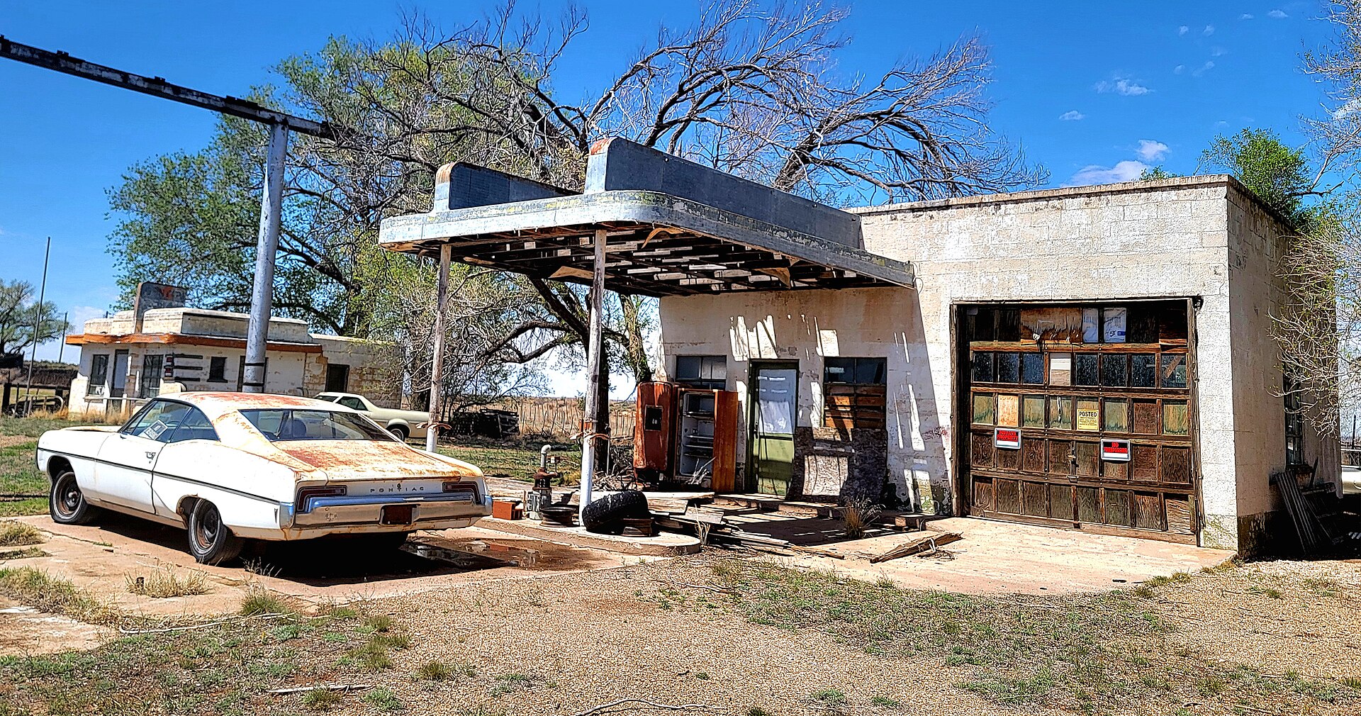
The abandoned Streamline Moderne diner and filling station at Glenrio.
Streamline Moderne curves built to catch a motorist’s eye at speed — now weathering quietly beside the empty road. Photo: Jim Heaphy (Cullen328), CC BY-SA 4.0, via Wikimedia Commons.
“Occupied” vs. abandoned. Some NPS descriptive text still says the Joseph Brownlee house and an office portion of the Texas Longhorn Motel are occupied — language that tracks the 2005 National Register field survey, not a guaranteed statement of who lives there now. Glenrio is a living historic district: at least one residence has been occupied, and the surrounding land is an active cattle ranch. Read the roadway and public views as current; don’t assume any building is empty (or open) today.

Timeline

~1903
The Rock Island Railroad establishes a siding, then called “Rock Island,” on the state line.
1907
The townsite is platted on the New Mexico side by the Rock Island Townsite & Investment Co.
1910
The Amarillo–Tucumcari line is completed; the depot is built and the town becomes Glenrio.
1911
Congress confirms the 1859 survey line, leaving Glenrio permanently split between Texas and New Mexico.
1926
The corridor is designated U.S. Route 66; the roadside economy begins to eclipse the railroad.
1945–75
Route 66 heyday: Brownlee’s Texaco and Little Juarez Café, the Texas Longhorn Motel, and the 1955 First/Last sign.
1955
The Rock Island depot closes; the rails are later removed in the 1960s.
1973
Interstate 40 opens just north of town; through traffic is gone by about 1975.
1976
Larry Lee Travis is murdered in Adrian, TX; his 1968 Pontiac is parked in Glenrio as a lasting memorial.
1985
The Glenrio post office closes — the town’s last public institution.
2007
The Glenrio Historic District is listed on the National Register (in both Texas and New Mexico).
2023–26
A cannabis dispensary opens on the NM side and relights a reproduction “First/Last” sign — border arbitrage returns.

Visiting Glenrio now

The practical answer: Glenrio can be driven through and photographed from the public road, but it is not an open-air museum where the abandoned buildings are automatically public. There’s no gate, no fee, and no NPS park unit — just a National Register district that public roads happen to cross, sitting on a patchwork of private and state land.

Plan your visit
Getting There
I-40 Exit 0 (Texas), south onto Loop 504 into town; westbound, NM I-40 Exit 373 to State Line Rd. Follow historic Route 66 west.
Fees
None. It’s a public road through a historic district, not a ticketed site.
Road Surface
Texas side (Loop 504): paved. New Mexico side (NM 1578): gravel/caliche, dry-weather only — impassable when wet.
West of Town
Pavement ends at the state line; the 1926–52 Route 66 continues ~14.6 mi of dirt toward San Jon (timber bridges, culverts, old rail grade).
Services
None on site — no water, restrooms, or fuel. Nearest at the New Mexico Welcome Center on westbound I-40 at the line.
Visitor Info
The Glenrio Visitor Information Center (I-40, NM side) is a modern facility, open daily ~7:30 a.m.–4 p.m. — not inside the historic district.
⚠ Weather, roads & unstable buildings. Summer heat and sudden Llano storms are serious; the unpaved New Mexico segment turns to thick mud when wet, and flash floods wash out culverts and bridges west of Endee (a bridge culvert washed out in May 2023). The surviving structures are privately owned and structurally unstable — entering them is illegal trespass, not exploration. Watch for rattlesnakes, and don’t disturb ranch livestock.
National Register status does not grant public access. The 31.7-acre district boundary is not an access boundary. Stay on the public road and right-of-way and clearly public pull-offs; treat buildings, yards, fenced land, gates, and side parcels as private unless an owner has opened them. There is no historical reason to trespass — the best compositions (the sign, the diner, the motel, the open plains, the old rail grade) are all right there from the roadway. Leave everything as you find it.
Glenrio straddles the Texas–New Mexico line at I-40 Exit 0, about 73 miles west of Amarillo.

Nearby Route 66 stops & ghost towns

Endee
~5 mi W · New Mexico
The closest true ghost-town landscape: ruined early-1900s stone stores, timber homesteads, and abandoned fuel stations along the unpaved 1926–52 Route 66 roadbed and the old rail grade.
San Jon
~18 mi W · New Mexico
Not a ghost town, but the western end of the dirt Route 66 segment — a still-inhabited community with WPA stone culverts, vintage auto courts, and 1930s service stations.
Tucumcari
~41 mi W · New Mexico
The Mother Road’s great survivor: miles of restored neon, the 1939 Blue Swallow Motel, Tee Pee Curios, and the New Mexico Route 66 Museum — the opposite outcome to Glenrio.
Adrian
~24 mi E · Texas
The geographic midpoint of Route 66 — 1,139 miles from both Chicago and L.A. — home to the MidPoint Café and the midpoint sign. (Also where Larry Lee Travis was killed.)
Vega
~37 mi E · Texas
The Oldham County seat, with the National Register–listed 1947 Vega Motel, a restored 1920s Magnolia filling station, and a 1915 courthouse — a county seat that survived the interstate.
Glenrio Visitor Info Center
I-40 at the state line
A modern New Mexico Tourism facility (not the ghost town) with maps, restrooms, and current road, weather, and safety information — the right place to check conditions before the dirt segment.

For more ghost towns on the archive, see Tonopah, St. Elmo, and Terrace.

Further reading

Nominations, surveys & Route 66 histories
Glenrio Historic District — National Register nomination (2007)
Philip Thomason · the essential source: chronology, boundaries, and resource-by-resource description, with separate Texas and New Mexico records.
Locally Maintained Route 66: Glenrio to San Jon (1993)
David Kammer · National Register documentation of the 14.6-mile dirt segment — the 1930 realignment, WPA culverts, and timber bridges.
Route 66 in Texas — Multiple Property Documentation (2007)
Ruth Keenoy & Terry Foley · Texas Historical Commission / NPS — regional context for roadside properties across the Panhandle.
New Mexico Route 66 on Tour: Legendary Architecture from Glenrio to Gallup (2001)
Donald J. Usner & Louise Stiver · a principal New Mexico Route 66 source that begins at Glenrio.
Tucumcari Tonite! (2022)
David H. Stratton · University of New Mexico Press — railroads, Route 66, and the waning of a western town just west of Glenrio.
Route 66: The Mother Road (1990) & Route 66: The Highway and Its People (1988)
Michael Wallis; Quinta Scott & Susan Croce Kelly · the classic narrative and documentary histories of the road, both recording Glenrio.
“Glenrio, TX” — Handbook of Texas Online
Hugh Allen Anderson · Texas State Historical Association — homesteading history, the Glenrio Tribune, and census changes.

Sources:

National Park Service, “Glenrio Historic District” & Route 66 road-segment pages — nps.gov.

Glenrio Historic District, National Register of Historic Places nomination (listed Jan. 17, 2007; Deaf Smith Co., TX #06001258 & Quay Co., NM #06001259).

“Locally Maintained Route 66: Glenrio to San Jon,” NRHP nomination (David Kammer, 1993); “Route 66 in Texas” MPDF (Texas Historical Commission / NPS, 2007).

Hugh Allen Anderson, “Glenrio, TX,” Handbook of Texas Online — tshaonline.org. “Glenrio, New Mexico and Texas,” en.wikipedia.org.

Legends of America, “Glenrio – One More Route 66 Casualty”; Diana Spechler, Texas Monthly / Route 66 News on the Glenrio Smoke Stop (2025–2026).

Photo credits: Hero (motel & “First Motel in Texas” sign) and café: Wordbuilder — CC BY 3.0, via Wikimedia Commons. Abandoned Streamline filling station: Jim Heaphy (Cullen328) — CC BY-SA 4.0, via Wikimedia Commons. No freely licensed Route 66-era photograph of Glenrio was available, so the images here are modern views of the surviving buildings.
← Explore more ghost towns

Similar Posts

Leave a Reply

Your email address will not be published. Required fields are marked *