Mammoth and Robinson, Utah: The Tintic Mining Camp That Grew Into Two Towns in One Canyon
Quick facts
Tintic district organizedDecember 13, 1869
Mammoth claim recordedFebruary 26, 1870
Robinson founded1893–94, named for George H. Robinson
Building boom1892–1910
Population at peakAbout 2,500–3,000 (estimate, 1900–1910)
Mammoth City incorporated1910; dissolved November 29, 1929
Tintic Miners’ Hospital1902–1933
Last regular rail shipmentMay 1958
Mammoth post office closedNovember 1, 1973
National RegisterMammoth Historic District, March 14, 1979
Elevation~6,400 ft (upper camp to ~7,000 ft)
State / CountyUtah / Juab County
What survivesA few homes, foundations, mine dumps and workings; condition varies and is largely unverified
⚠ Not a managed historic park · Residents live here · Structures and mine ground are private or claimed · Lethal mine hazards
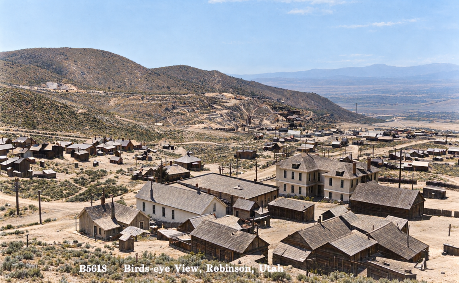
Colorized bird's-eye view of Robinson, Utah, with frame and brick buildings across the canyon floor and a wide valley behind
A bird’s-eye view of Robinson, the lower half of the Mammoth mining community, with the valley opening behind it. Colorized with AI; the colors are an interpretation. Original photo: Utah State Historical Society.

Mammoth was never one town. It began in 1870 as a rough camp in a steep ravine at the foot of Mammoth Peak, and by the 1890s it had spilled a mile down the canyon into a second town, Robinson, built where the mills and the railroad could reach it. The two grew together into a single mining community of a few thousand people, with churches, saloons, a newspaper, a theater and the only hospital in the Tintic district.

Today the canyon is a dispersed ruin landscape: mine dumps, cut terraces, foundations and a scattering of old houses, much of it on private ground that is also being explored for minerals. This post follows how it rose, what the documents support, and what you can and cannot expect to see.

“Boys, she’s a mammoth strike!”

A locator’s words as Tintic oral tradition tells how the claim got its name (tradition, not a documented quotation)

Tintic and the Mammoth claim, 1869–1880

The Tintic Mining District was organized on December 13, 1869, after a prospector named George Rust found the Sunbeam vein. Mammoth followed almost at once. The original Mammoth claim was recorded on February 26, 1870, by Thomas G. Wimmer, William D. Wimmer, Robert Wimmer, Joseph W. Wright and John W. Tanner, and neighboring ground was staked a few weeks later by others, including the Crismon brothers. The deposit was a large, steeply pitching, copper-gold-silver ore body in faulted limestone, with an open stope at the surface that became known as the “Old Glory Hole.”

Early life in the hollow was hard. Mammoth sat at more than 6,400 feet, with little timber, no farmland and almost no water. Miners from Cornwall, Ireland, Germany and Wales lived in dugouts, tents and rough stone huts, and one account says water was hauled up from Eureka Gulch and sold by the barrel at ten cents a gallon. A wooden gravity pipeline from Jenny Lind Spring eased the shortage in the 1880s.

Ore treatment was the bigger problem. Between about 1872 and 1874 the Crismon-Mammoth venture built iron smelting furnaces and shipped early copper matte. Between 1876 and 1879 a 27-stamp mill was assembled in the valley, but refractory copper minerals defeated pan amalgamation. A British venture, Mammoth-Copperopolis Ltd., made the mine famous overseas, and an English syndicate that held an option later collapsed after the death of its principal backer.
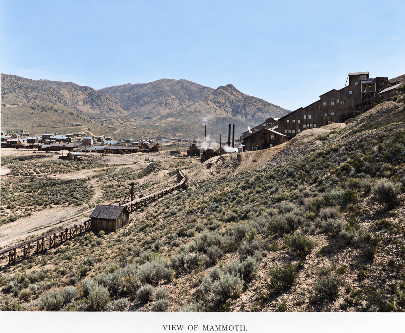
Colorized view of Mammoth, Utah, with a large multi-story mill building on the hillside at right, a flume or tramway, and the camp spread out below
A view of Mammoth, with the large mill and mine buildings climbing the hillside at right and the camp below. Colorized with AI; the colors are an interpretation.Original photo: Utah State Historical Society

The McIntyre brothers and the cattle trade

The best-known Mammoth story involves Samuel and William McIntyre, Texas-born brothers who built a ranching empire in Utah. The University of Utah’s archival description of the McIntyre papers records that in 1873 the brothers traded cattle for a substantial interest in the Mammoth Mine. That core is documented. The brothers sank the shaft deeper, and the mine grew into a large underground operation. The McIntyres later combined ranching and mining interests under the Samuel McIntyre Investment Company, and the family’s success also brought conflict: Samuel McIntyre Jr. eventually sued his father.

One account says the Mammoth paid between $3 million and $4 million in dividends from 1872 to 1930, and that in 1899 Samuel bought William’s 103,000 shares for more than $250,000 to take sole family control. Both figures come from a single compilation and should be treated as approximate.

On the cattle-for-a-mine legend: The 1873 trade is documented. The popular retelling goes further: the sellers thought the mine nearly worked out, gladly took the herd, and watched the McIntyres sink deeper and strike a fortune. The herd size, the dialogue and how quickly the bonanza came are family or local tradition and are not tied to contemporary records. A 1990s newspaper retelling preserves the dramatic version, but it should not carry the same weight as the archive.

Robinson and the two-level town, 1890–1910

By the 1890s the mines were up the canyon but the mills and railroads belonged below. Around 1893–94 the Mammoth company built a large stamp mill near the canyon mouth, and a town grew around it. It was named Robinson for George H. Robinson, a mining engineer and mill superintendent, who is documented as the town organizer. The 1977 National Register survey records a residence there as early as 1892.

Upper Mammoth held the shafts, hoists, boarding houses and company offices. Robinson held the mills, the railroad yards, lumber suppliers and shops. The canyon floor between them filled with houses and stores, a stretch called “Middletown.” Mammoth had a post office from 1890 until November 1, 1973, and Robinson had its own from 1896 to 1914. In 1910 the two were incorporated together as Mammoth City.
On Robinson and the stories about him: Local histories say Robinson laid out the town as a monument to himself, and that he lost his job after chartering a private train at company expense to carry him to Salt Lake City. Both are mining-camp lore. Robinson’s role as an engineer and town organizer is documented, but his motives and the train story are oral tradition, not established fact. One compilation also credits him with an 18-mile pipeline from Cherry Creek to the lower mills, which should be verified before it is repeated.
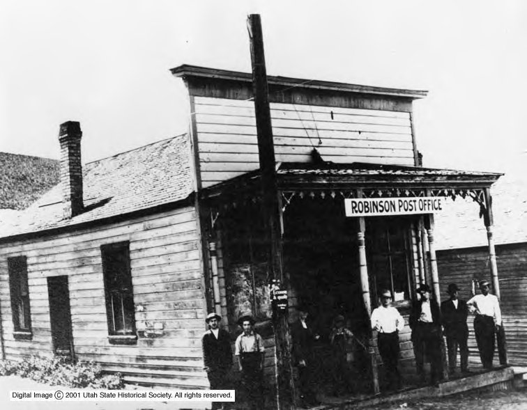
Black-and-white photo of the Robinson Post Office, a weathered frame building with a sign over the porch and several men standing in front
The Robinson Post Office, with men standing on the front porch and boardwalk.Original photo: Utah State Historical Society
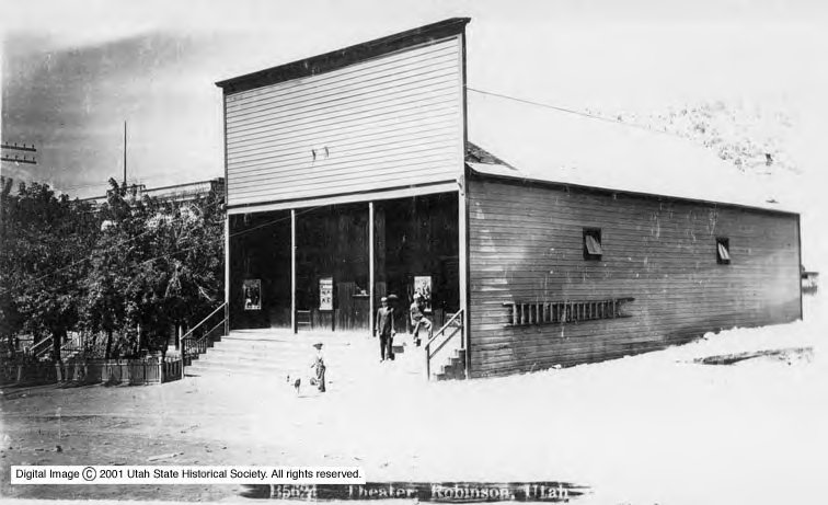
Black-and-white photo of the theater at Robinson, a building with a wooden front and brick side wall, a wide staircase to the entrance and a boy and a dog in front
The theater at Robinson, with a wide entrance stair and a boy and a dog below.Original photo: Utah State Historical Society

Railroads climb the hollow

Rail made Robinson. The Rio Grande Western built the Tintic Range Railway into the district by 1892, and the competing Union Pacific-controlled Salt Lake & Western pushed south as well. In January 1894 the two lines agreed to share track and a union depot at Robinson. To bring ore down from the high mines, mine owner James A. Cunningham and associates incorporated the New East Tintic Railway in 1896, a standard-gauge line that climbed Mammoth Hollow on a 6 percent grade with geared Shay locomotives and served the ore bins of the Gold Chain and Ajax mines. The Oregon Short Line bought it in November 1900 for $37,000, according to the UtahRails history.

The Grand Central and the apex lawsuit

The neighboring Grand Central Mine drove Mammoth’s second wave. A 1900 USGS description notes that the top of the great Grand Central ore body lay nearly 1,000 feet below the surface, which showed how much rich ore could lie deep. Merchant and investor John Dern, who also developed Mercur, led the company, and his son George later became governor of Utah and Secretary of War.

Underground, the Mammoth and Grand Central workings eventually met. In late 1901 Grand Central sued Mammoth in Grand Central Mining Co. v. Mammoth Mining Co., one of the best-known apex disputes in Utah mining law. The fight turned on the federal Mining Law of 1872, which lets a claimant follow a vein that apexes inside the claim downward beyond its side lines. Mammoth argued that one continuous vein dipped into Grand Central ground. Grand Central said the ore occurred in separate replacement chimneys and accused Mammoth of taking more than $300,000 in silver ore. Mammoth’s expert witness was geologist James E. Talmage, later an apostle of the Latter-day Saint Church. The trial court ruled against Mammoth, the Utah Supreme Court upheld it, and in 1909 the U.S. Supreme Court dismissed Mammoth’s final petition.

On the lawsuit and the all-steel headframe: The apex case details come from a single research compilation, so confirm dates and amounts in the court record before quoting them. That compilation also says the Grand Central built the first all-steel headframe west of the Mississippi River, a claim that is widely repeated but that I could not trace to a firm source. The headframe is a notable structure either way, but whether it still stands should be checked before you plan a trip around it.

Life in the canyon at its height

Between about 1900 and 1910 Mammoth and Robinson reached their peak. Regional histories commonly estimate the combined population at 2,500 to 3,000, in roughly 350 homes and other buildings. The National Register survey found that about 85 percent of the buildings still standing in 1977 were built between 1892 and 1910, which marks the boom clearly. The community had several churches, a public school, a grandstand ballpark, fraternal lodges, about a dozen saloons, a movie theater, a weekly newspaper called The Mammoth Record and the Hotel Mammoth.
On the population: Figures vary. One compilation gives 1,828 as the 1910 federal census count for the combined communities and also cites a peak near 2,800. Another repeats 2,823. Changing municipal boundaries and the Mammoth and Robinson names make false precision likely, so 2,500 to 3,000 around 1900–1910 is the safest statement. What is certain is how far it fell: the 1977 preservation survey found only about 35 residents.
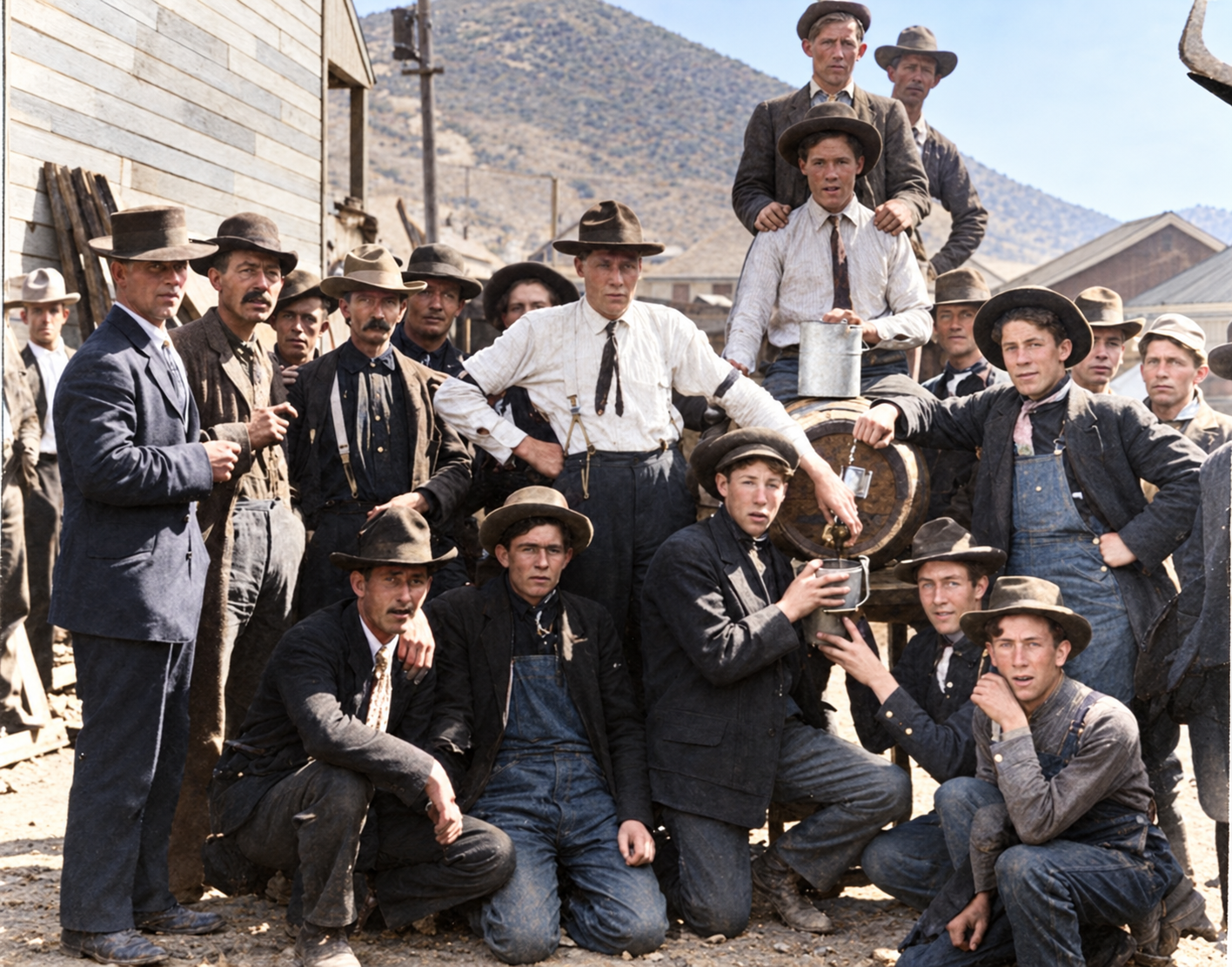
Colorized photo of a crowd of miners and townsmen in work clothes and hats gathered around a keg, with a hillside behind
Miners and townsmen gathered around a keg. The occasion is not identified. Colorized with AI; the colors are an interpretation.Original photo: Utah State Historical Society
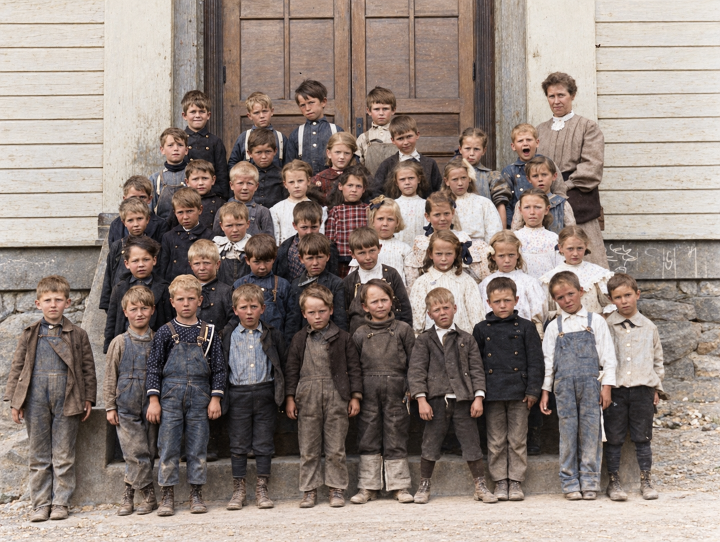
Colorized class portrait of Mammoth, Utah, schoolchildren and a teacher posed on the steps of a school building
A class portrait of Mammoth schoolchildren and their teacher on the school steps. Colorized with AI; the colors are an interpretation.Original photo: Utah State Historical Society

Labor in the Tintic camps

Labor relations in the Tintic district are described as comparatively cooperative next to Cripple Creek, Coeur d’Alene or Bingham. The Eureka Miners’ Union formed in 1890, and a Western Federation of Miners local followed in 1902. A brief regional strike and lockout in February 1893 followed an attempt to introduce sliding-scale wages tied to the silver price. One compilation says that in 1912 Tintic miners disavowed the violent Bingham strike and won wage increases of $3.00, $3.25 and $3.50 a day, and that the Eureka and Mammoth unions merged in 1913.

On a “Mammoth strike”: I did not find strong primary evidence for a single violent “Mammoth strike” of the kind that can be documented at Bingham, Park City or the Utah coalfields. Tintic labor history is best followed in Notarianni’s district study, and the 1912 and 1913 details above should be checked against it.

Fires, a bankrupt city and the long decline, 1912–1973

The camp’s wooden buildings burned repeatedly. A fire in 1912 swept Robinson’s commercial core, destroying its theater, confectionery and post office, and the Robinson post office closed within two years. The old Mammoth company store burned in 1926 and was replaced by the surviving masonry building, and a 1928 fire destroyed the central mine offices, which were rebuilt. The joint railroad depot at Robinson burned in 1942.

Money problems were more decisive. In July 1925 the courts removed several hundred acres of patented mine ground from Mammoth City’s boundaries, taking away its power to tax the Mammoth and Grand Central mines. Voters dissolved the city’s charter on November 29, 1929, and by 1930 the population had dropped to about 750. Underground, stopes below 2,000 feet moved from rich oxidized ore into lower-grade pyrite and arsenic sulfides, and workings flooded at about 200 gallons a minute at the 2,600-foot level. Leasers shipped dump ore and flux through the 1930s, with 474 rail cars in 1935 and 938 in 1937. The McIntyre family sold out in 1954. The last regular commercial rail shipment, a modest 120 tons, left in May 1958, and the Mammoth post office closed on November 1, 1973.

On the fires, the hospital and the ore cars: The 1926 and 1928 fires and the hospital’s history are tied to the National Register inventory. Internet ghost-town accounts also repeat stories of fabulously rich single ore cars, armed guards and widespread “high-grading,” where miners took pieces of rich ore. High-grading certainly happened across western mining, but I found no solid contemporary Mammoth source for the dollar amounts, so treat those stories as unverified local lore.

The Tintic Miners’ Hospital

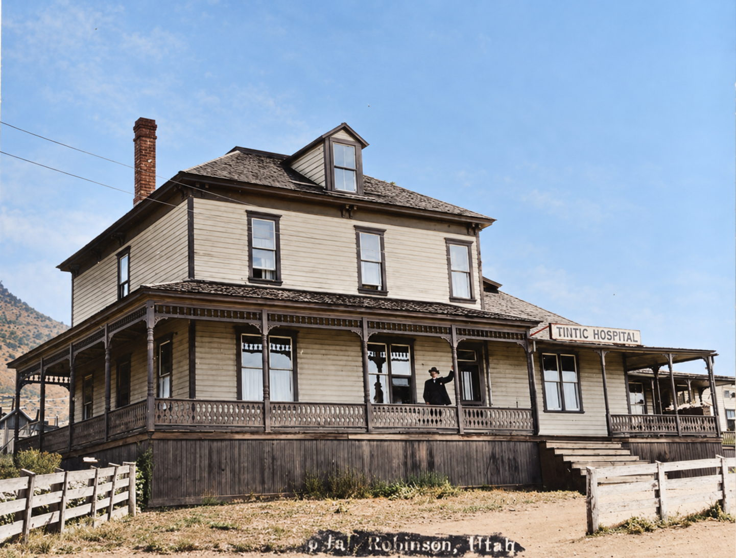
The district’s only hospital, the Tintic Miners’ Hospital, opened at Mammoth in 1902, with Dr. Steele Bailey Sr. treating injuries and silicosis. It operated until 1933. The building was destroyed around 1935, and by 1977 a monument marked the site. Photographs of it are among the best surviving glimpses of everyday life in the canyon.
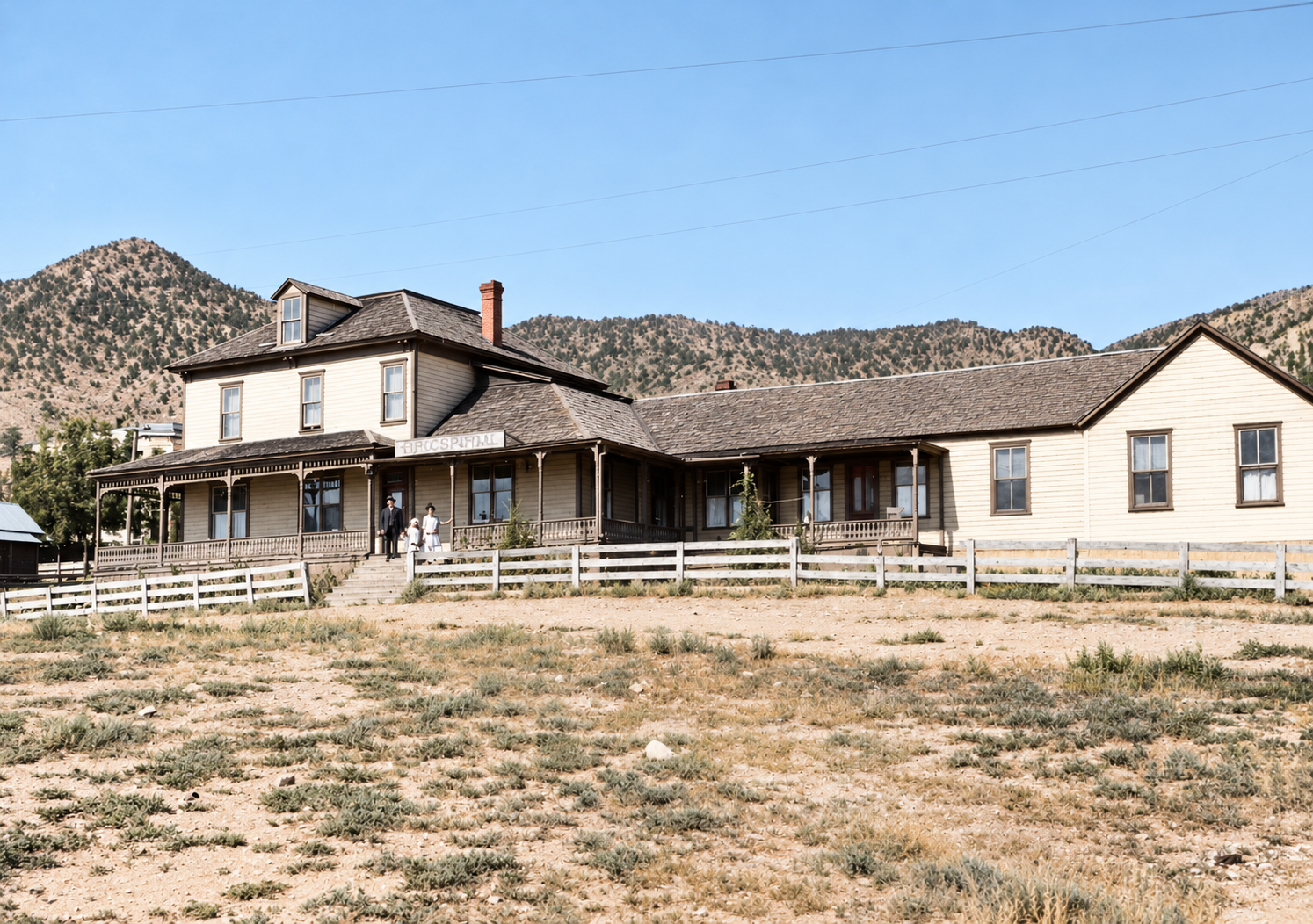
Colorized photo of the long two-story Tintic Miners' Hospital with a wide porch, a white fence and hills behind
The Tintic Miners’ Hospital, with a long porch and white fence. Colorized with AI; the colors are an interpretation.Original photo: Utah State Historical Society
Colorized close view of the Tintic Hospital, a two-story frame building with a wraparound porch, a hospital sign and a person standing on the porch
A closer view of the Tintic Hospital, with its sign visible and a person standing on the porch. A handwritten label places it at Robinson. Colorized with AI; the colors are an interpretation.Original photo: Utah State Historical Society

What is left today

The best architectural record of Mammoth is the 1977 National Register survey, which led to the listing of the 170-acre Mammoth Historic District on March 14, 1979. It inventoried about 49 surviving structures and ruins, including vernacular frame homes from 1892–1910, a two-story boarding house dating to about 1875, the 1928 mine office, the brick fire station of about 1930, the Mammoth Supply Company store, the foundations of the church and school, and the ruins of the Farrell Mill of 1895. That list is a snapshot of 1977. Nearly half a century has passed, and a building listed then should not be assumed standing now.

A December 2024 corporate filing for the current exploration project describes historical shafts, adits and mine remains across the property but says there is no significant operating mining equipment or infrastructure. The Mammoth and Grand Central headframes appear in many historical photos, but whether any given headframe or ore bin survives needs to be confirmed before it is the reason for a trip. What you can count on finding is a dispersed ruin landscape: mine dumps, cuts, shafts or closed openings, foundations, grading, a few scattered buildings and roads.

On “unlisted” survivors: Sources disagree on what still stands. A research compilation lists a Grand Central steel headframe, the Old Beanery boarding house and the McIntyre residence as surviving, while another notes that the 1977 inventory is the last full survey and that current condition is not verified. Both are given here as possibilities, not confirmed facts.

Timeline

December 13, 1869
The Tintic Mining District is organized after the Sunbeam discovery.
February 26, 1870
The original Mammoth claim is recorded.
1872–1879
Early smelting and a 27-stamp mill struggle with refractory copper ore.
1873
The McIntyre brothers trade cattle for a substantial interest in the Mammoth Mine.
1890
The Mammoth post office opens.
1892
The Tintic Range Railway reaches the district.
1893–1894
Robinson is founded; the two railroad lines agree on a joint depot in January 1894.
1896
The New East Tintic Railway is incorporated; Robinson’s post office opens.
1901–1909
Grand Central sues Mammoth over the apex rights; the U.S. Supreme Court ends the case in 1909.
1902
The Tintic Miners’ Hospital opens.
1900–1910
Peak years, with an estimated 2,500–3,000 residents.
1910
Mammoth and Robinson incorporate as Mammoth City.
1912–1914
A fire hits Robinson; its post office closes by 1914.
1925
A court decree removes patented mine ground from the city.
1926 and 1928
Fires destroy the company store and the mine offices.
November 29, 1929
Voters dissolve Mammoth City.
1933–1935
The hospital closes and is later destroyed.
1942
The joint depot at Robinson burns.
1954
The McIntyre family sells its interests.
May 1958
The last regular commercial rail shipment leaves.
November 1, 1973
The Mammoth post office closes.
March 14, 1979
The Mammoth Historic District is listed on the National Register.
Visit guide — Mammoth and Robinson, Utah
Can you visit?Only to a limited degree. Mammoth is not a park or a managed historic site. A few dozen people live there, and the ruins, headframes, mine dumps and claims are private property or active mining claims. Public access is confined to the public road. National Register status does not make private land public.
Getting thereFrom I-15, take Exit 244 at Santaquin and follow US-6 west about 23 miles over Homansville Pass to Eureka. Mammoth is a few miles south of Eureka by local roads, reaching the Robinson area first, with the upper camp beyond. Do not search for “SR-270”: that route number is in the Salt Lake City area and is wrong for this trip, and one source that listed it was mistaken.
CoordinatesMammoth: about 39.927°N, 112.125°W · elevation ~6,400 ft
RoadsUS-6 is a maintained state highway. Beyond it, county and mine roads are steep, rocky and narrow, and can end at gates, private lots or active work areas. High clearance is advised, and deep clay mud makes them hard in spring. No official road-condition service covers them.
Land statusA December 2024 filing says the current exploration company acquired the patented claims on the Mammoth property in August 2023 and describes an exploration-stage project, with drilling in 2024. Check parcels with the Juab County Recorder and the BLM Mineral & Land Records System before you go. Posted signs and gates take precedence over any map.
Fees and facilitiesNo published entrance fee. There are no public restrooms, water or campgrounds. Residents have no municipal water system and haul water.
Best legal historical visitBase yourself in Eureka, whose historic district and Tintic Mining Museum show what a working camp looked like, and view the canyon from public roads. Silver City and Diamond are nearby but face the same access limits.
Best seasonLate spring through autumn. Avoid snowmelt and storms.
Serious hazards: Utah’s Division of Oil, Gas and Mining warns that abandoned mines hold vertical shafts hundreds of feet deep, rotten timbers, and low-oxygen or toxic air that gives no warning. Never enter an adit, shaft or glory hole, walk on shaft collars, ore-bin floors or trestles, or climb headframes and mill ruins. Do not throw rocks into shafts, and keep children and pets close.
Respect residents and private ground: Do not enter buildings, drive off the road or collect minerals or artifacts without a landowner’s permission. Mine dumps and tailings carry lead, arsenic and cadmium, so avoid kicking up dust, and wash hands and footwear afterward.
Approximate location of Mammoth in Mammoth Hollow, south of Eureka, Juab County, Utah. Most of the surrounding ground is private or claimed; see the visit guide.

Historic sites nearby

Further reading

Books, studies and records about Mammoth and Tintic
Faith, Hope & Prosperity: The Tintic Mining District
Philip F. Notarianni · Tintic Historical Society, 1982 — The standard district history, strong on workers and communities.
Description of the Tintic Special District
George Otis Smith · USGS Geologic Atlas Folio 65, 1900 — Essential for the camps at their first great boom, including the deep Grand Central ore body.
Geology and Ore Deposits of the Tintic Mining District, Utah
Waldemar Lindgren and G. F. Loughlin, with a historical review by V. C. Heikes · USGS Professional Paper 107, 1919 — The mature USGS treatment of the Main Tintic district.
Geologic Map of the Mammoth Mine Area, Tintic District, Utah
H. T. Morris · USGS Open-File Report 62-89, 1962 — A map of the mine area itself.
A History of Juab County
Pearl D. Wilson, June McNulty and David Hampshire · Utah Centennial County History Series, 1999 — The best county-scale narrative.
Mammoth Historic District National Register nomination
National Park Service, 1979 — The most useful source for reconstructing the town’s buildings as they stood in 1977.
Nuggets from Mammoth, Utah
Lucille Toone — Local anecdotes and memories. A rich source of folklore, to be checked against records.
MammothRobinsonUtahGhost TownUtah Ghost TownsTintic Mining DistrictJuab CountyMammoth HollowGrand Central MineMcIntyre FamilySilver MiningGold MiningCompany TownNational Register of Historic Places

Sources

National Park Service — Mammoth Historic District National Register documentation (1977 survey) — the 1892–1910 building boom, Robinson as town organizer, the 1926 and 1928 fires, the hospital, and surviving structures

UtahRails.net — Tintic History, 1977 — district chronology, post offices, municipal history and the decline

UtahRails.net — New East Tintic Railway (1896–1900) — the mining railway up Mammoth Hollow and its sale

Utah Division of State History — Eureka (Utah) Photograph Collection — historic views of Mammoth, Grand Central and Lower Mammoth

University of Utah Libraries — McIntyre Ranch digital photograph collection — the 1873 cattle-for-mine transaction and the McIntyre family

U.S. Geological Survey — Description of the Tintic Special District (1900) — Grand Central’s deep ore body and the principal towns

Utah Division of Oil, Gas and Mining — Stay Out, Stay Alive! — abandoned-mine hazards

Bureau of Land Management — Mineral & Land Records System and abandoned-mine dangers — checking claims and understanding risks

Utah Geological Survey — mining district compilations for Tintic — deposit type and production background

Additional detail draws on the research compilations assembled for this post, which cite UtahRails.net, Western Mining History, the Mining History Association’s History of Tintic Mining District, a December 2024 SEC filing and other sources. Distances to Knightsville, Mercur, Ophir and Bingham Canyon were calculated from coordinates. Historic photographs courtesy of the Utah State Historical Society. Images marked “colorized” were colorized with AI and are interpretations, not original color.
Similar Posts

Leave a Reply

Your email address will not be published. Required fields are marked *