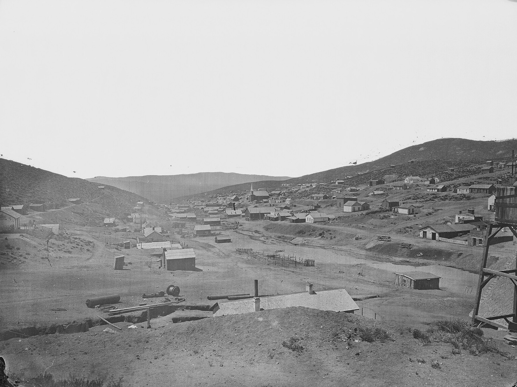
View of Austin, Nevada in Pony Canyon, about 1868

Austin, Nevada: The “Mother of Mining Camps” on the Loneliest Road
Quick facts
What it isA 1860s silver camp that never quite emptied; now a small highway town
Silver foundMay 2, 1862, in Pony Canyon
Mining district organizedJuly 10, 1862
County seatLander County, 1863 to 1979
Census peak1,679 in 1880 (promoters claimed 10,000)
Population today167 (2020 census)
Silver producedEstimates run from $19 million to $50 million
Main mine companyManhattan Silver Mining Company, stopped in 1887
RailroadNevada Central, 1880 until scrapped in 1938
ElevationAbout 6,600 feet (sources give 6,555 to 6,605)
LocationAbout 39.49°N, 117.07°W, US-50
State / CountyNevada / Lander County
⚠ Living town with fuel and lodging · Stokes Castle is fenced, view from the turnout · Old mine workings in the hills are dangerous · Remove nothing
Black-and-white view of Austin, Nevada, in 1868, with frame buildings scattered along a hillside canyon, a headframe at right and dry hills beyond
Austin in Pony Canyon, about 1868. Photograph by Timothy H. O’Sullivan of the King Survey, from a National Archives scan. Public domain.

Austin is the rare Nevada mining camp that outlived its boom without dying. It was founded in the spring of 1862 on the steep east side of the Reese River valley, grew into the supply capital of central Nevada, and sent prospectors off to found the camps around it. When its silver gave out in the 1880s the town shrank to a few hundred people, but the stone and brick buildings of its main street stayed in use. Today Austin sits on US-50, the “Loneliest Road in America,” with a gas station, a saloon in a hotel that is more than 160 years old, a stone castle on the hill and about 170 residents.

A Pony Express rider finds silver

Before the rush, this country was a seasonal home of the Western Shoshone, who gathered piñon nuts on the high ridges. Captain James H. Simpson surveyed a wagon route across central Nevada in 1859, and in 1860 the Pony Express, the Overland Mail stage and then the first transcontinental telegraph all followed it. At Jacobsville, a station on the Reese River about six miles west of Pony Canyon, a former Pony Express rider named William Talcott worked as a station keeper.

On May 2, 1862, Talcott was hauling firewood out of Pony Canyon when he noticed dark-stained quartz that looked like the horn silver of the Comstock. Assays in Virginia City confirmed rich ore, and the “Rush to Reese” was on. Miners organized the Reese River Mining District on July 10, 1862 and wrote their own rules for claims.

On the pony legend: A popular story says a Pony Express pony kicked a boulder loose and exposed a rich vein. The documented account is simpler: Talcott found the outcrop while cutting wood for the stage station.

Clifton loses to Austin

At first there were two towns. Promoters laid out Clifton on the flat where Pony Canyon opens onto the valley floor and expected it to become the district’s commercial center. Its lot prices, though, angered miners. In early 1863 a prospector and promoter named David Buel, refused a free lot, joined with disaffected miners and platted a rival town higher up the gorge, close to the big veins of Lander Hill and Union Hill and next to the springs. Austin had water, fair lot terms and the mines. By late 1863 Clifton was largely a ghost, and many of its frame buildings had been hauled uphill to Austin.

Austin was the Lander County seat by autumn 1863 and was incorporated as a city in 1864. The new city soon had a police force, volunteer fire companies, piped water and four churches.

On the name: Sources disagree about where “Austin” came from. One says Buel named it for his home town of Austin, Texas. Another says it was named for his partner, Alvah Austin.

Mother of mining camps

Austin’s banks, assay offices, machine shops and warehouses supplied prospectors across the Great Basin, and parties that set out from Austin found ore that started Eureka, Belmont, Hamilton, Cortez, Ophir and Ione. That is why the town was nicknamed the “Mother of Mining Camps.” Its own mines were rich, but the ore was stubborn. The surface carried easy horn silver, while below the water table the silver was bound up in complex sulfide minerals that ordinary pan mills lost in their tailings. Local metallurgists developed what became known as the Reese River process: dry-crush the ore, mix it with salt, roast it in a furnace to turn the silver into chloride, then amalgamate it with mercury. The method spread across the West.

The costs of such mills pushed small operators out, and the Manhattan Silver Mining Company eventually combined dozens of claims on Lander Hill into one operation with its own shafts, pumps and reduction works. A rush to White Pine pulled miners east in 1869, and the camp rebounded through the 1870s as the company sank shafts past 1,000 feet. In 1887 falling silver prices, rising pumping costs and narrowing veins at depth ended it. The district had produced somewhere between $19 million and $50 million in silver.

On how many people lived here: Early promoters and a state historical marker claimed that Austin had 10,000 or more residents in the mid-1860s. The 1870 federal census found 1,324 in Austin itself and 2,815 in the whole county, which then covered a large part of northeastern Nevada. The peak census count for the town was 1,679 in 1880. Historians suggest the wider district, with its outlying camps and transient miners, may have held 5,000 to 7,000 people in 1864 and 1865. The state later revised its marker to read “several thousand.” Accounts also disagree on later numbers: one says a few thousand were still here by 1900, while the census counted 702.

Two little railroads

Freight by wagon to the Central Pacific line cost a fortune, so in 1879–80 investors built the Nevada Central Railroad, a 93-mile narrow-gauge line from Battle Mountain south to the valley flat below Austin. Because it stopped short of town, local investors also built the 2.8-mile Austin City Railway, which climbed the canyon on grades of about 10 percent to the mills and Main Street. At first it ran on mule power, 11 mules hauling a single car. In 1881 a small steam “dummy” engine from the Baldwin Locomotive Works replaced them and was nicknamed the “Mules’ Relief.” The town line closed by the early 1890s after a derailment and the mining slump. The Nevada Central lasted longer, through several receiverships, until it was abandoned and scrapped in 1938.

The sack of flour

Austin’s best-known story starts in the spring of 1864 with a bet. Reuel Colt Gridley, a Democratic grocer, wagered with Republican candidate Dr. H. S. Herrick on the town’s first municipal election. The loser was to carry a 50-pound sack of flour. The Republicans won on April 20, and Gridley shouldered the sack and walked from Clifton up to Austin behind a brass band, with his young son carrying a Union flag.

At the top of town, instead of keeping it, Gridley auctioned the sack to benefit the United States Sanitary Commission, the Civil War agency that supplied medical care to wounded Union soldiers. The winning bidder gave it back to be sold again, and the bidding became a contest. The sack was auctioned in Nevada mining towns, in Virginia City, in California and eventually at the Sanitary Fair in St. Louis. Mark Twain, then a reporter in Virginia City, described the sack in Roughing It. Gridley’s health and business suffered on the tour. He went bankrupt and died in California in 1870, aged 41.
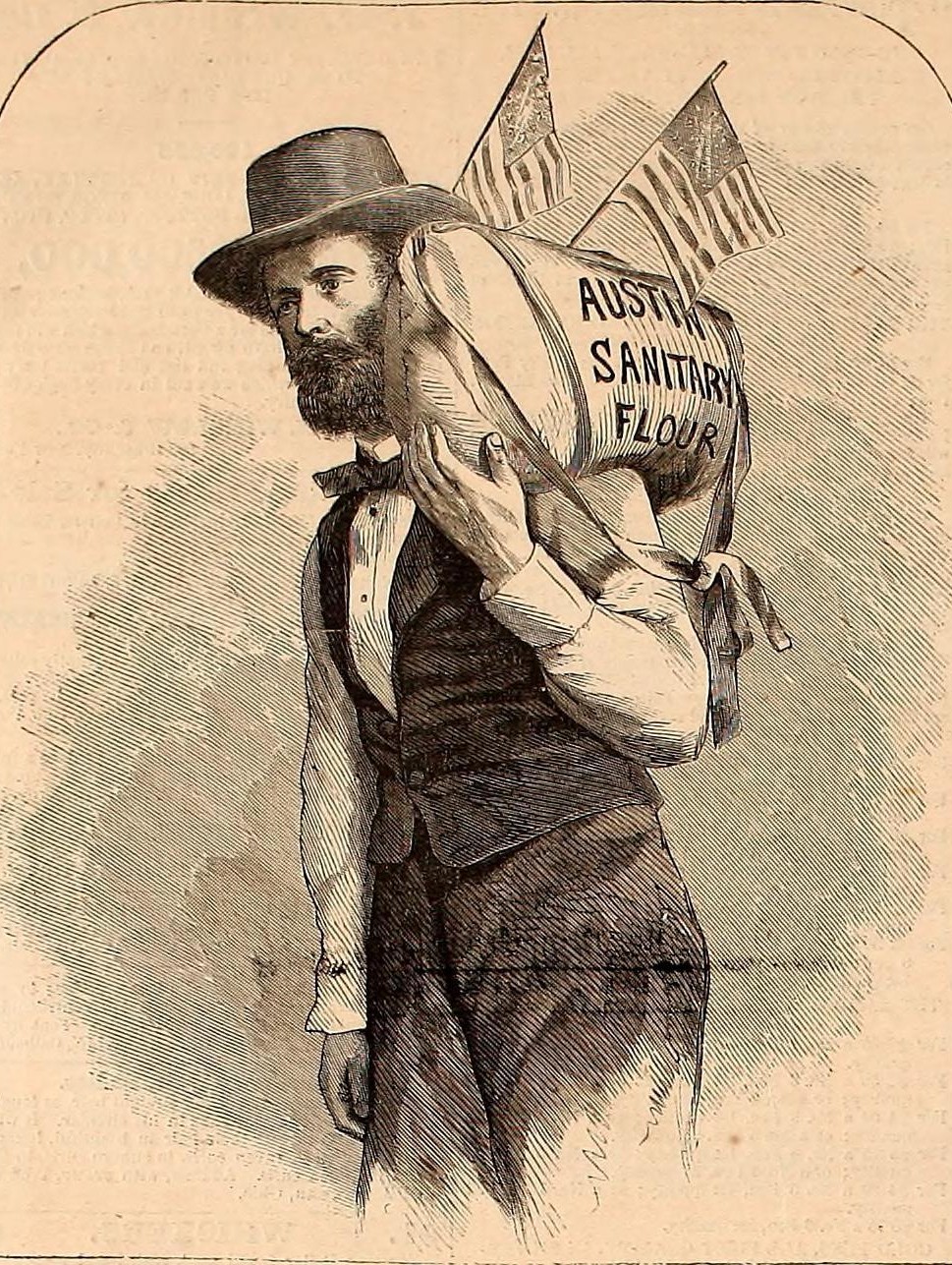
Wood engraving of a bearded man in a hat and vest carrying a large flour sack marked Austin Sanitary Flour on his shoulder, with two small flags
Reuel Colt Gridley and his sack, from a wood engraving published in Harper’s Weekly in 1865 after a photograph made in San Francisco. Public domain.Image: Harper’s Weekly, 1865, via Wikimedia Commons
On the flour sack’s numbers and details: Retellings differ. Totals range from about $150,000 to more than $250,000 and as much as $275,000 for the whole tour. A figure of about $8,000 in a single day at Austin is often repeated. Some tellings have Gridley losing a mayoral race rather than winning a bet by proxy, and Twain’s own account is humorous and partly exaggerated. The core of the story, the election bet and the repeated auctions for the Sanitary Commission, is well documented. A local tale that Gridley’s ghost haunts his stone store on Water Street is folklore.

The Reveille and the Sazerac Lying Club

Austin also had a lively press. William C. Phillips started the Reese River Reveille on May 23, 1863, and the paper traded barbs and stories with the Virginia City Territorial Enterprise and writers such as Mark Twain and Dan De Quille. In the 1870s, under editor Fred H. Hart, it reported on the Sazerac Lying Club, a group of miners and saloon regulars who swapped deadpan tall tales in the back room of the Sazerac Saloon. Hart collected them in an 1878 book, The Sazerac Lying Club, now a classic of Western frontier humor.

Stokes Castle

West of town on a ridge above the mouth of Pony Canyon stands the building people photograph most. Stokes Castle is a three-story tower of rough granite built in 1896–97 for Anson Phelps Stokes, a New York banker and mining investor who also led the Nevada Central Railroad. It is said to be modeled on a Romanesque watchtower he saw near Rome. Inside were fireplaces on every level, plate-glass windows and wood balconies and a rooftop viewing deck over the Reese River valley. The family used it only briefly in 1897 and 1898 and sold their local holdings in 1898. After decades of weather the wood interior and balconies collapsed, leaving the stone shell. A Stokes relative, Molly Knudsen, bought it in 1956 to keep it from being torn down, and it was added to the National Register of Historic Places in 2003.
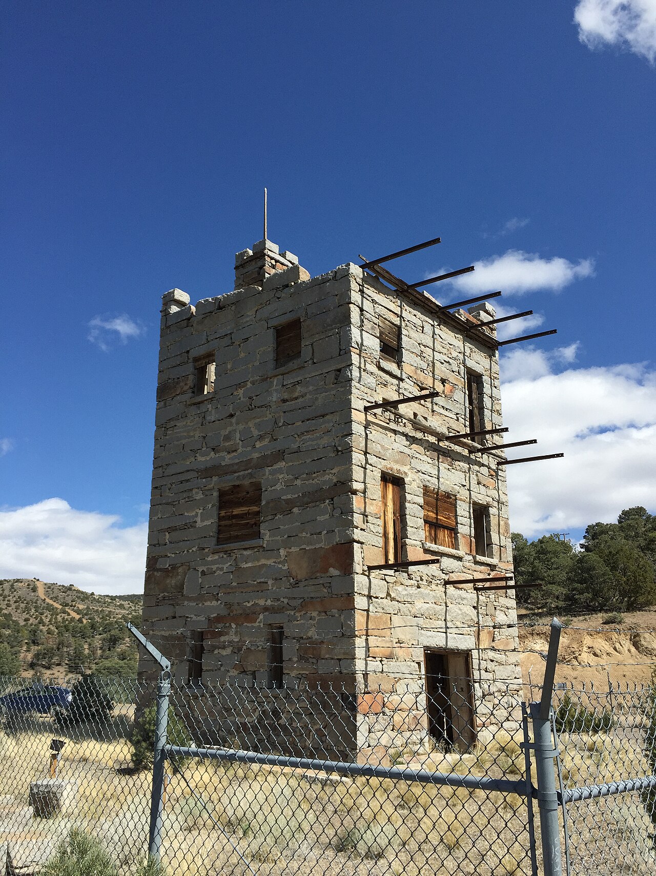
Three-story granite tower with boarded windows and bare timber ends sticking out at the top, behind a chain-link fence, under a blue sky
Stokes Castle, fenced off to protect the ruin. Photographed April 2, 2015.Photo: Famartin, via Wikimedia Commons, CC BY-SA 4.0
On the castle’s abandonment: A ghost story says the Stokes family fled after a single night because of spirits, or the desert winds. The documented record is less dramatic: they stayed about a month in 1897, made a few later visits, and left when Stokes liquidated his Austin interests.

Main Street today

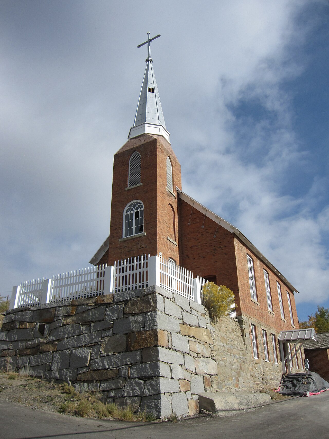
Austin’s main street climbs the canyon, and many of its brick and stone buildings are still standing. The Lander County Courthouse, built in 1871 to a design by Daniel P. Bell, is a two-story brick building with Greek Revival touches. The court moved to Battle Mountain when the county seat did in 1979, and the building has housed county offices since. St. Augustine’s Catholic Church, built in 1866, is generally described as the oldest surviving Catholic church building in Nevada; it has a 75-foot belfry, 1939 biblical murals by Rafael and Duff Jolly and an 1884 Kilgen pipe organ, and it has been restored as a cultural center. The Methodist church (1866) and St. George’s Episcopal Church (1877–78) also survive, and the Gridley store dates to 1863. The International Hotel, which still runs a saloon, began as a Virginia City building in 1859 and was taken apart, hauled over the mountains by wagon and put back together in Austin in 1863.
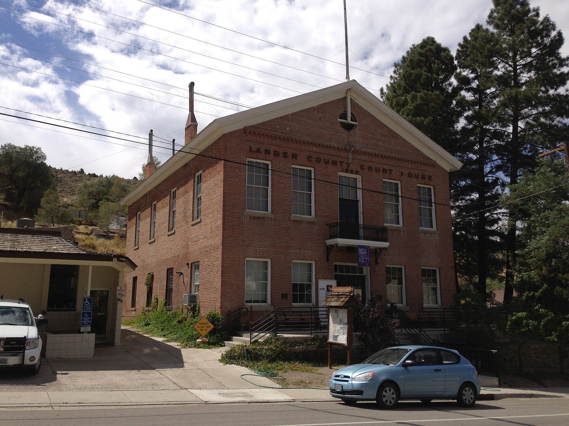
Two-story red brick courthouse with a small balcony and a sign reading Lander County Court House, beside a parking lot and trees
The 1871 Lander County Courthouse on Main Street. Photographed September 8, 2014.Photo: Famartin, via Wikimedia Commons, CC BY-SA 4.0
Red brick church with a tall white steeple and cross, standing above a stone retaining wall and a white picket fence
St. Augustine’s Catholic Church (1866). Photographed October 13, 2013.Photo: Chris M Morris, via Wikimedia Commons / Flickr, CC BY 2.0
On the courthouse: Accounts disagree about it. Some call it rusticated granite and give a cost of about $85,000, while others describe a brick building that cost about $30,000. The building itself is brick. A local tale says vigilantes carried out hangings from its small second-floor balcony; the records show only trials, filings and prisoners held in its jail. Sources also differ on whether St. George’s was finished in 1878 or 1879.

Uranium and turquoise

Two later finds kept prospectors interested. In 1953 Joe and Rudy Rundberg found uranium minerals about three miles south of town, and the Apex mine ran until 1968 and produced the mineral apexite. In 1973 Rita Hapgood found a small, rich pocket of turquoise in hills north of Austin. Known as Lander Blue, it yielded roughly 90 to 110 pounds of vivid blue spiderweb turquoise, among the most valuable in the world.

Timeline

1859–1860
A survey opens a central route across Nevada; the Pony Express and stage follow.
May 2, 1862
William Talcott finds silver in Pony Canyon.
July 10, 1862
The Reese River Mining District is organized.
Early 1863
Austin is laid out above Clifton and quickly draws the crowd.
1863
The county seat moves to Austin; the Reese River Reveille begins.
1864
Austin is incorporated; Gridley’s flour sack is auctioned for the Sanitary Commission.
About 1868
Timothy O’Sullivan photographs the town.
1869
The White Pine rush pulls miners east.
1871
The Lander County Courthouse is built.
1880
The Nevada Central and the Austin City Railway open; census peak of 1,679.
1887
The Manhattan Silver Mining Company stops milling and pumping.
1896–1897
Stokes Castle is built.
1938
The Nevada Central is abandoned and scrapped.
1953–1968
The Apex uranium mine operates.
May 15, 1979
A special election moves the county seat to Battle Mountain.
2003
Stokes Castle and the courthouse are listed on the National Register.
Visit guide — Austin, Nevada
Can you visit?Yes. Austin is a living town. Main Street is open to walk, and most historic sites can be seen from the street or visited by appointment or in season.
Getting thereAustin sits on US-50, the “Loneliest Road in America.” It is about 90 paved miles south of Battle Mountain on SR-305, 111 miles east of Fallon and about 70 miles west of Eureka.
CoordinatesAbout 39.49°N, 117.07°W. Approximate.
MuseumThe Austin Historical Society Museum on Main Street is open seasonally, roughly April to October, usually mid-day. It is free, with donations welcome. Hours depend on volunteers, so call ahead.
ChurchesSt. Augustine’s Cultural Center on Virginia Street opens for scheduled events, concerts and posted open-house hours. Other churches are usually used by their congregations.
Stokes CastleReached by a marked gravel road off US-50 on the west side of the canyon, a short drive from town. Accounts differ on the exact side of the highway and distance, so follow signs. The tower is fenced; view the exterior from the turnout and do not climb the fence.
ServicesGas and groceries, a few motels, small restaurants and the International Hotel saloon. The nearest other fuel is in Eureka, Battle Mountain and Fallon. Cell service is spotty.
TerrainStreets are steep, 12 to 15 percent in places, with uneven stone steps, at about 6,600 feet. Shady streets ice over in winter, and the passes on US-50 can need chains.
CampingThe Forest Service’s Bob Scott Campground, about 6 miles east on US-50, is open roughly mid-May to late October for a small fee.
Land statusSurrounding Toiyabe Range land is mostly Humboldt-Toiyabe National Forest or BLM, open without a permit; there are no facilities or marked trails and roads are rough high-clearance tracks.
Serious hazards: The hills above Austin are full of old shafts, adits and stopes. Do not enter any mine opening; rotten timber, deep winzes and bad air have killed people. Keep off mine dumps and walk carefully on steep slopes.
Respect the ground: Collecting artifacts, metal-detecting for relics and removing masonry, nails or bottles from federal land is prohibited under federal preservation law. Carry water and take only photographs.
Approximate location of Austin, Nevada, in Pony Canyon on the east side of the Reese River valley.

Historic sites nearby

Belmont, NV
~55–60 miles south, also on this site
Silver camp and old Nye County seat · 1876 courthouse
Berlin, NV
~50 miles south-southwest, also on this site
Gold-silver camp in Berlin–Ichthyosaur State Park
Virginia City, NV
~150 miles west, also on this site
The Comstock; origin of Austin’s International Hotel
Clifton, NV
~1 mile west
Rival camp of 1862–63 · Stone foundations and rail grades
Jacobsville, NV
~6 miles west
Pony Express and stage station · Plaque and foundations
Hickison Petroglyph Area
~24 miles east
BLM rock art site · Short trail and primitive camping

Further reading

Books, studies and records about Austin and the Reese River district
Austin and the Reese River Mining District: Nevada’s Forgotten Frontier
Donald R. Abbe, 1985 — The standard scholarly history.
The Town That Died Laughing
Oscar Lewis, 1955 — Social history drawn from the Reese River Reveille.
Romancing Nevada’s Past
Shawn Hall, 1994 — Ghost towns and mining camps of Eureka, Lander and White Pine counties.
Geology and Ore Deposits of the Reese River District, Lander County, Nevada
Clyde P. Ross, USGS Bulletin 997, 1953 — Mining geology of the district.
The Reese River Country
J. Ross Browne, Harper’s New Monthly Magazine, June 1866 — An eyewitness account.
Roughing It
Mark Twain, 1872 — Chapter 45 describes the Sanitary flour sack.
Austin NevadaNevadaLander CountyReese RiverSilver MiningStokes CastleLoneliest RoadNevada Ghost Towns

Sources

Nevada SHPO — Austin historical marker

Western Mining History — Austin, Nevada

Wikipedia — Austin, Nevada; Stokes Castle; Lander County Courthouse; Reuel Colt Gridley

The Mark Twain Project — Roughing It, Chapter 45

Greater Austin Area Chamber of Commerce — Rich History

Travel Nevada — St. Augustine’s Cultural Center; Austin Historical Society

Photos: Austin, about 1868, Timothy H. O’Sullivan, National Archives (public domain). Gridley engraving, Harper’s Weekly, 1865 (public domain). Stokes Castle and courthouse photographs by Famartin, CC BY-SA 4.0. St. Augustine’s Church photograph by Chris M Morris, CC BY 2.0. All via Wikimedia Commons.
Similar Posts

Leave a Reply

Your email address will not be published. Required fields are marked *