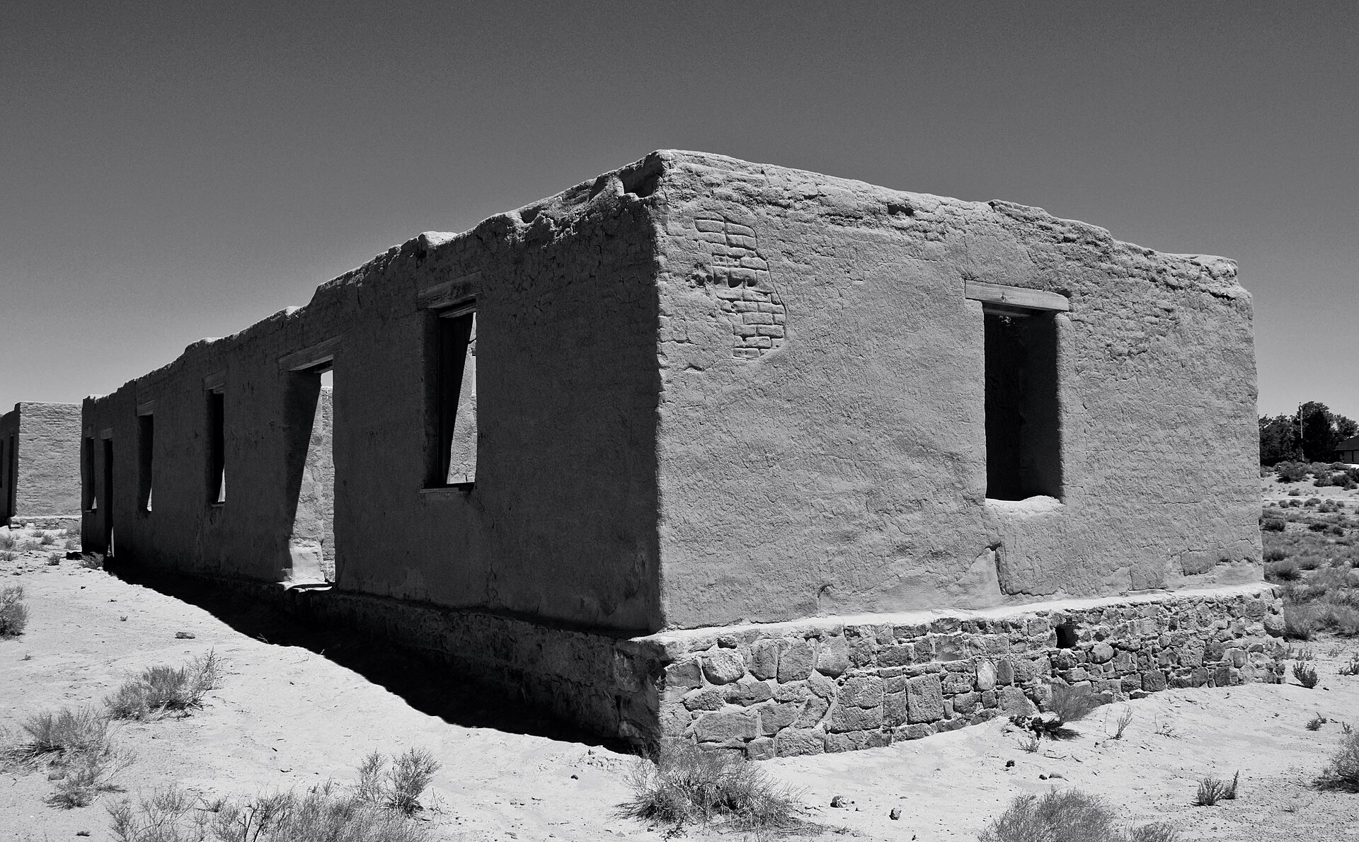
Adobe ruins of a building at Fort Churchill State Historic Park, Nevada

Fort Churchill, Nevada: Adobe Ruins of a Civil War Frontier Post
Quick facts
What it isAn 1860s U.S. Army post, now stabilized adobe ruins in a state historic park
FoundedJuly 20, 1860, on the Carson River
Named forSylvester Churchill, Inspector General of the Army
Abandoned1869, after the transcontinental railroad opened
Sold at auctionLate 1869, for $750, to Samuel Buckland
StabilizedBy the Civilian Conservation Corps, 1934–1935
State park1957 (National Historic Landmark, 1961)
Park sizeAbout 3,200 to 3,500 acres (sources differ)
LocationAbout 39.29°N, 119.27°W, off US-95A
State / CountyNevada / Lyon County
⚠ Open daily, sunrise to sunset · Day-use fee · Stay on the trails and off the walls · Remove nothing
Roofless adobe building at Fort Churchill with a stone foundation, window openings and a sandy foreground under a dark sky
Adobe ruins at Fort Churchill, on a stone footing. Photo: Jpledia, via Wikimedia Commons, CC BY-SA 3.0.

Fort Churchill was built in a hurry and abandoned nine years later, but it was never a boomtown or a mining camp. It was the U.S. Army’s biggest outpost in what is now Nevada, put up on the Carson River in the summer of 1860 to keep the road to the Comstock Lode open. Its soldiers guarded the Pony Express and the telegraph, watched for Confederate sympathizers in Virginia City and kept a wary peace with the Northern Paiute. Then the railroad bypassed it, the Army left, and a local rancher bought the buildings for $750. What remains are the thick adobe walls of the officers’ quarters, barracks, hospital and magazine, preserved by the state in a condition called “arrested decay.”

A war that built a fort

The Comstock silver rush of 1859 brought thousands of newcomers over the Sierra into Northern Paiute country. Miners cut the piñon pines the Paiute relied on for winter food, and emigrants’ livestock grazed the river bottoms. Tension broke in May 1860 at Williams Station, a trading post and stage stop on the Carson River. According to research, employees there had seized two Paiute girls. On May 6 a Paiute raiding party attacked the station, killed several men and freed the captives.

A volunteer militia of about 100 men from Virginia City and nearby towns marched toward Pyramid Lake under Major William Ormsby. On May 12 the Paiute, whose leader Numaga had urged peace and then accepted that the war could not be avoided, ambushed and routed the militia near the lake. Ormsby was among the dead. Territorial leaders sent urgent pleas to California, and the Army answered with a force under Captain Joseph Stewart of the 3rd Artillery, which joined volunteers under Colonel Jack Hays. On June 2, 1860 they fought the second Battle of Pyramid Lake and drove the Paiute back, ending the large-scale fighting.

On the numbers and the blame: Sources disagree on how many men died in the first battle and on how many people were killed at Williams Station, and the abduction story comes from accounts recorded after the fact. Most modern histories accept it as the spark. The date of the first battle, May 12, 1860, is well documented.

Choosing the Carson River

Stewart first built a temporary earthwork on the Truckee River, called Fort Haven. But the main emigrant road, the stage line and the Pony Express all ran south along the Carson River, and his superiors ordered him to establish a permanent post there. He marched his command roughly 40 miles southeast and, on July 20, 1860, camped on a terrace on the north bank of the Carson, across from Samuel Buckland’s trading post and bridge. The site had water, grass and a clear view along the river, and it was close to the road west.

Stewart asked the War Department on July 23 to name the post for Sylvester Churchill, the Army’s Inspector General, a veteran of the War of 1812 and the Mexican War. The name was confirmed on August 28, 1860.
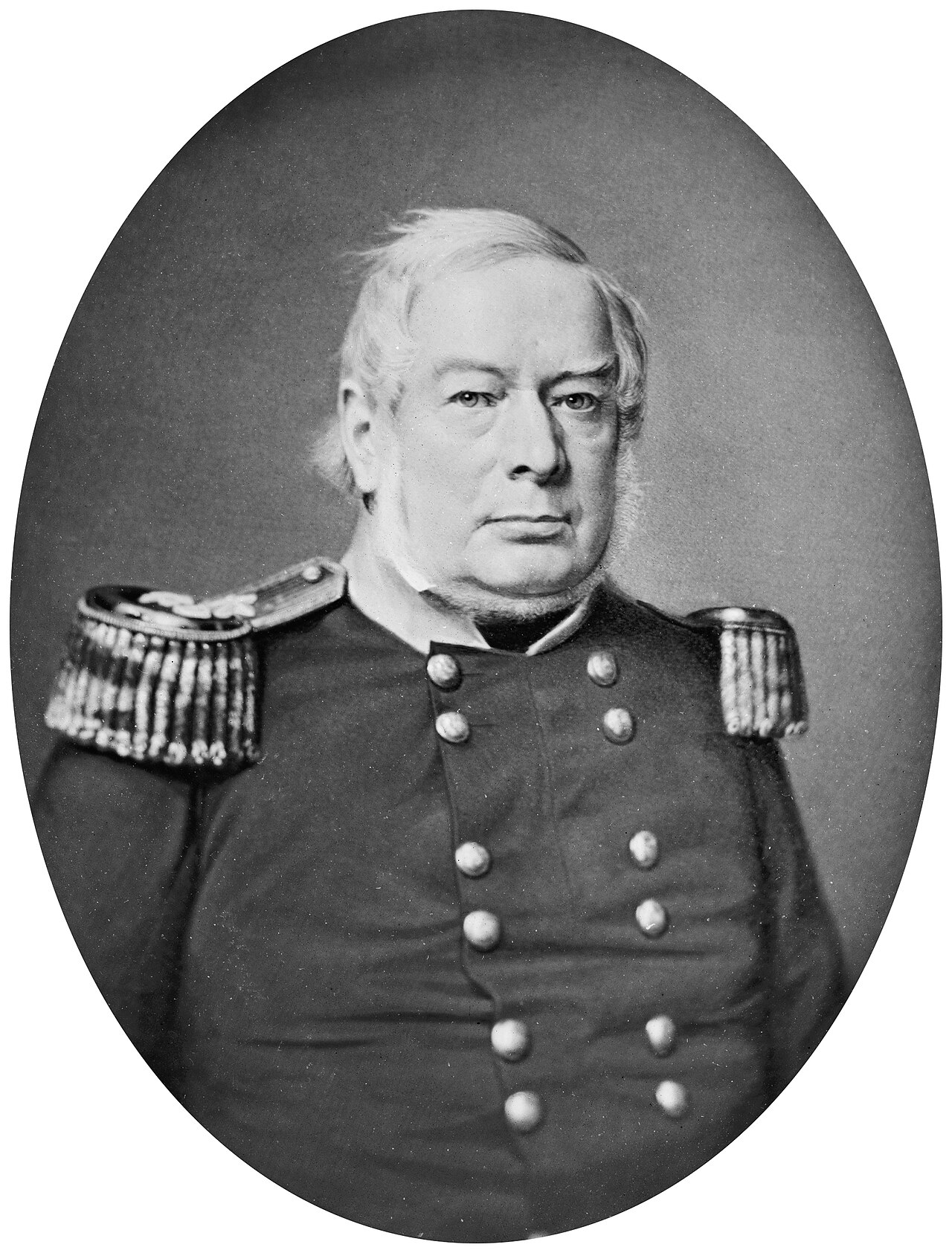
Oval portrait of an older man with white hair in a military coat with epaulettes and buttons
Sylvester Churchill, Inspector General of the Army, for whom the post was named. From the Civil War glass negative collection, Library of Congress. Public domain.Image: Library of Congress, via Wikimedia Commons

Building in adobe

Unlike most frontier posts, which were wooden stockades or temporary camps, Fort Churchill was meant to last. Its adobe buildings were arranged around a large parade ground, with officers’ quarters, barracks and mess halls, a hospital, a guardhouse, a powder magazine, storehouses, stables and a laundresses’ row. Soldiers and workers made bricks from the silt and clay of the river bottom and laid the walls on footings of local stone. There was no useful timber nearby, so the roof beams, floors and window frames were hauled over the Sierra by mule team. Freight alone was costly. One account puts the initial appropriation at $75,000 and says it was quickly spent. According to some accounts the post had about 20 buildings by fall 1860 and as many as 58 at its height. It was the largest and best-fortified post in the territory.

The powder magazine was built with thick adobe walls and a light, unfastened wooden roof, so that if it exploded the blast would go up rather than sideways into the rest of the fort.
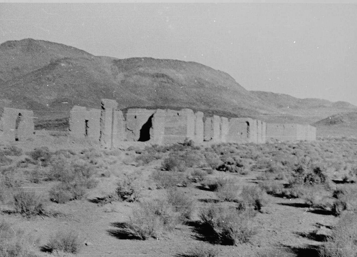
Black-and-white photograph of a long line of broken adobe walls across a sagebrush flat, with a bare mountain behind
A long stretch of the fort’s ruined adobe walls, with mountains behind. Historic American Buildings Survey, National Park Service. Public domain.Image: Historic American Buildings Survey, via Wikimedia Commons and the Library of Congress
On the number of buildings: Accounts give different totals. One says the post had more than 20 adobe buildings by the fall of 1860. Another says 58 stood around the parade ground. The sources do not explain the gap.

Life at the post

Officers had a comfortable posting. They lived in plastered quarters with fireplaces and could ride to Virginia City or Carson City for theater and balls. Enlisted men had a harder time. Summers passed 100°F and the wind drove alkali dust into every seam, and winters were cold. Privates earned about $13 a month and spent their days making adobe, digging ditches, hauling firewood and standing guard. Desertion, drinking and courts-martial were common. Archaeologists who dug the post’s trash heaps in the 1970s found the difference between ranks in what was thrown away: porcelain, stemware and wine bottles near the officers’ row and plain stoneware, whiskey bottles and clay pipe stems near the barracks. They also recovered percussion caps, .58-caliber bullets and early metallic cartridges.

The Pony Express, the telegraph and the Civil War

The fort’s first job was to protect the roads. The Pony Express had begun in April 1860, and the Pyramid Lake War closed it for weeks. Buckland’s station, a short way from the fort, was a relay stop. The most famous ride of that spring belonged to Robert “Pony Bob” Haslam, who found his relief rider unwilling to go on and pressed east and back for a round trip of about 380 miles. In the fall of 1860 the telegraph wire reached the fort from California, and for a time the post was the easternmost telegraph point. In 1861 it became a base for building the western section of the Overland Telegraph, whose completion in October 1861 ended the Pony Express.

When the Civil War began, the Regular Army troops went east and California volunteers took their place. Fort Churchill became the supply depot for the Military District of Nevada. Virginia City had many Southern sympathizers, and detachments from the fort patrolled the Comstock towns, escorted silver shipments and arrested suspected secessionists. A Confederate plot to raise troops in Virginia City in 1864 is said to have collapsed under this pressure. The Confederate threat, however, was mostly political; no major battle was fought in Nevada.

On the garrison and the Pony Express: Garrison estimates run from about 150 to 200 soldiers in 1860, when the British traveler Richard Burton noted only two companies, to as many as 600 in late 1861. Sources differ on whether the fort itself was a Pony Express station. Buckland’s station was the relay, and the fort’s role was protection and its telegraph office. Claims that Confederate sympathizers in Storey County numbered in the thousands come from Union reports of the time and may be inflated.

The end of the fort and Buckland’s auction

When the Civil War ended in 1865 the garrison shrank to a single company. In 1869 the Central Pacific and Union Pacific met at Promontory Summit, the stage and mail lines on the Carson River ended and the telegraph moved to the railroad. The Army had no more reason to hold the post and abandoned it that year. In late 1869 the government sold the buildings at auction for $750.

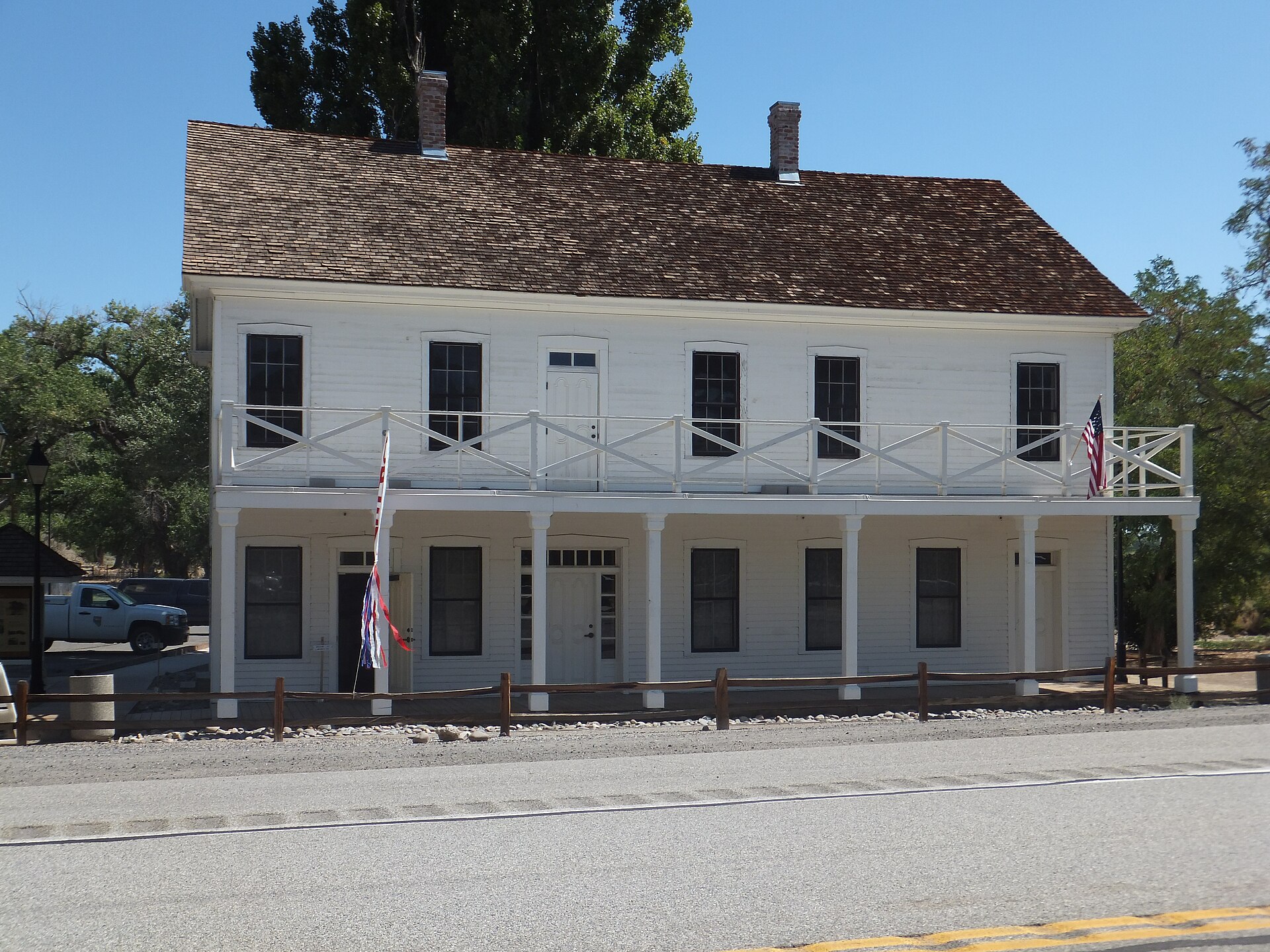
Samuel Buckland, the rancher who had built the bridge and trading post across the river, bought them and stripped them of roofs, floors, doors, windows and brick. He used the materials to build a large two-story ranch house in 1870 that still stands as Buckland Station. Without roofs or plaster, the raw adobe softened in rain and snow and began to melt back into earth.
On who bought what: Accounts disagree. One says Buckland bought all 58 buildings for $750. Others say he bought most of them, and one park history says only that they were auctioned for $750. Sources also differ on Buckland’s house, calling it Greek Revival, 18 rooms, 2½ stories or two stories, and placing it a mile or so from the fort in different directions.
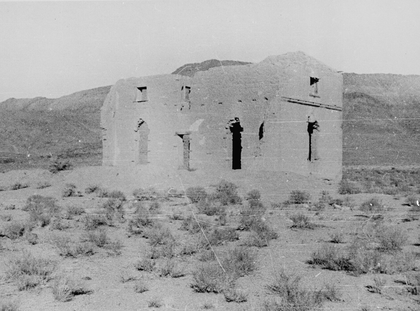
Black-and-white photograph of a roofless two-story adobe building with empty doorways and windows on a sagebrush flat
A ruined two-story adobe building at the fort. Historic American Buildings Survey, National Park Service. Public domain.Image: Historic American Buildings Survey, via Wikimedia Commons and the Library of Congress
Two-story white building with a covered porch, a railed upper balcony and a dark shingle roof beside a road
Buckland Station, the 1870 ranch house built partly from materials salvaged from the fort.Photo: William Hoffknecht, via Wikimedia Commons, CC BY-SA 3.0

Saved from the weather

By the early twentieth century the fort was low walls, tall chimneys and mounds. The Nevada Daughters of the American Revolution helped preserve the core of the site, and the state took control of about 200 acres. In 1934 the National Park Service and the Civilian Conservation Corps set up a camp there, and over two years the workers cleared drifted silt, stabilized the walls, replaced bad adobe with new bricks made from river clay and built the stone-and-timber visitor center that still stands. Fort Churchill became a Nevada state park in 1957 and was named a National Historic Landmark in 1961. The state does not rebuild the walls. Instead it caps and re-plasters them, repoints the stone and manages drainage to slow the erosion, an approach it calls arrested decay.

Graves, folklore and the Buckland plot

About 44 to 46 soldiers were buried in the post cemetery between 1860 and 1869. In the 1880s the government moved them to Lone Mountain Cemetery in Carson City. Only the Buckland family plot remains at the fort, with the graves of Samuel and Eliza Buckland and five of their children inside a white picket fence.

On the reburial: Accounts give the year as 1884 or February 1885 and the number as 44 or 46. Nevada State Parks puts the move in 1884. One account says only one man could be identified, a commander killed in an ambush in 1865, but that detail appears in only one source. Treat the details as uncertain.
On ghost stories: Local tales describe a phantom sentry in a cavalry uniform near the guardhouse and magazine, hoofbeats on the trail to Buckland Station, bugle calls over the parade ground and a woman in Victorian mourning near the Buckland graves, said to be Eliza. These are modern folklore. They do not appear in nineteenth-century diaries, military records or official histories.

Timeline

1859
The Comstock Lode is found; Samuel Buckland opens a trading post and bridge on the Carson.
May 6, 1860
Williams Station is attacked, starting the Pyramid Lake War.
May 12, 1860
Ormsby’s volunteers are routed at Pyramid Lake.
June 2, 1860
Army and volunteers fight the second Battle of Pyramid Lake.
July 20, 1860
Captain Stewart camps on the Carson River terrace.
August 28, 1860
The post is officially named Fort Churchill.
Fall 1860
The telegraph reaches the fort from California.
1861
Regulars leave for the Civil War and volunteers take over; the Overland Telegraph is built east from the fort, and the Pony Express ends in October.
1865
The garrison shrinks as the war ends.
1869
The railroad is finished; the Army abandons the post and the buildings are auctioned.
1870
Buckland completes his ranch house from salvaged materials.
1934–1935
The Civilian Conservation Corps stabilizes the ruins and builds the visitor center.
1957
Fort Churchill becomes a Nevada state park.
1961
The site is named a National Historic Landmark.
Visit guide — Fort Churchill State Historic Park
Can you visit?Yes. The park is open every day of the year from sunrise to sunset.
Getting thereFort Churchill is on US-95A, about 8 miles south of Silver Springs, which is on US-50. The paved entrance road is fine for cars, trailers and RVs. The park address is listed as 10000 US-95A, Silver Springs.
CoordinatesAbout 39.29°N, 119.27°W. Approximate.
FeesRecent listings give a day-use fee of $5 per Nevada-registered vehicle and $10 for out-of-state vehicles. Fees change, so check the state park website.
Visitor centerThe CCC-built museum has displays on the fort, a model, uniforms and weapons. Sources give opening times from 8:00 to 8:30 a.m. and a closing time of 4 p.m., so call ahead.
Buckland StationThe 1870 house is open for self-guided tours on weekends from about 10 a.m. to 2 p.m., with extra days in summer, for a small fee ($1 in recent listings). The second floor is closed.
TrailsA level gravel loop of about three-quarters of a mile circles the parade ground with signs at the main buildings. A river trail of roughly 2 miles links the fort to Buckland Station, a shorter nature loop runs through the cottonwoods and a short spur climbs to the Buckland cemetery. Lengths differ between sources.
CampingA shaded campground has about 20 sites with tables and fire rings, no hookups, and a dump station. Riverside group and horse areas are available. Reserve through the state system or check on arrival.
ServicesFuel and groceries are in Silver Springs, Dayton and Yerington, roughly 10 to 30 miles away.
Heat and windSummer highs are often above 100°F with little shade at the ruins. Bring water and sun protection.
Fragile ruins: The adobe walls are unfired earth and can crumble. Do not climb, lean on or enter the ruins, and stay on the marked trails.
Respect the ground: Metal detecting, drones and collecting artifacts, stones or plants are prohibited. Pets must be on a short leash. Take only photographs.
Approximate location of Fort Churchill on the Carson River, Lyon County, Nevada.

Historic sites nearby

Virginia City, NV
~30 miles west, also on this site
The Comstock Lode, guarded by troops from the fort
Buckland Station
~1 mile
Pony Express stop and 1870 ranch house · Museum tours
Dayton, NV
~20 miles west
Early Carson River town · Dayton State Park and the Rock Point mill
Williams Station site
Northeast, distance varies by source
1860 attack site · Lost under Lahontan Reservoir
Como, NV
~18 miles southwest
1860s Pine Nut Mountains camp · Rough roads
Genoa, NV
~50 miles southwest
Nevada’s oldest settlement · Mormon Station State Park

Further reading

Books, studies and records about Fort Churchill
Historical, Architectural, and Archaeological Studies of Fort Churchill, Nevada
Donald L. Hardesty, ed., Nevada Division of State Parks, 1978 — The main archaeological and architectural study.
Fort Churchill: Nevada Military Outpost of the 1860’s
Stanley W. Paher, 1981 — A short popular history.
Early Nevada Forts
Nevada Historical Society Quarterly, vol. 7, 1964 — Founding records and orders.
The Pony Express in Central Nevada
Donald L. Hardesty, BLM Cultural Resource Series No. 1, 1979 — Stations and trails on the Carson route.
The War of the Rebellion: Official Records, Series I, Vol. 50
U.S. Government Printing Office, 1897 — Post returns and Department of the Pacific correspondence.
Fort ChurchillNevadaLyon CountyPony ExpressPyramid Lake WarCivil WarBuckland StationNevada Ghost Towns

Sources

Nevada State Parks — Fort Churchill State Historic Park; History of Fort Churchill

National Park Service — Fort Churchill State Historic Park

Wikipedia — Fort Churchill; Paiute War; Battle of Williams Station; Overland Telegraph Company

Nevada Historical Society Quarterly — Early Nevada Forts (1964)

Nevada Expeditions — Fort Churchill

Photos: Fort Churchill ruins by Jpledia and Buckland Station by William Hoffknecht, both CC BY-SA 3.0. Historic photographs of the ruins, Historic American Buildings Survey, National Park Service (public domain). Sylvester Churchill portrait, Library of Congress (public domain). All via Wikimedia Commons.
Similar Posts

Leave a Reply

Your email address will not be published. Required fields are marked *